Jump to content


Main menu


Navigation  


Main page
Contents
Current events
Random article
About Wikipedia
Contact us
Donate


Contribute  


Help
Learn to edit
Community portal
Recent changes
Upload file


Search  


Create account

Log in


Create account
 Log in


Pages for logged out editors learn more  


Contributions
Talk


Contents


(Top)


1 Bus lines  


2 References  


3 External links  


Fuente el Saz de Jarama: Difference between revisions


العربية
Aragonés
 / Bân-lâm-gú
Brezhoneg
Català
Cebuano
Deutsch
Español
Esperanto
Euskara
Français
Հայերեն
Interlingua
Interlingue
Italiano
Ladin
Lëtzebuergesch
Lombard
Magyar
مصرى
Bahasa Melayu
Nederlands
Нохчийн
Occitan
Oʻzbekcha / ўзбекча
Polski
Português
Русский
Svenska
Татарча / tatarça
Українська
Vèneto
Tiếng Vit
Winaray
Zazaki


Edit links


Article
Talk


Read
Edit
View history


Tools


Actions  


Read
Edit
View history


General  


What links here
Related changes
Upload file
Special pages
Permanent link
Page information
Cite this page
Get shortened URL
Download QR code
Wikidata item


Print/export  


Download as PDF
Printable version


Print/export  


In other projects  


Wikimedia Commons


Appearance


Coordinates: 40°3810N 3°3040W / 40.63611°N 3.51111°W / 40.63611; -3.51111

Help
 

From Wikipedia, the free encyclopedia


Browse history interactively
 Previous editNext edit 
Content deleted Content added
Tags: Mobile edit Mobile web edit
Line 91: Line 91:

* Line 197: Madrid (Plaza de Castilla) - [[Torrelaguna]] ([[ALSA]])

* Line 197: Madrid (Plaza de Castilla) - [[Torrelaguna]] ([[ALSA]])


* Línea 254: Valdeolmos/Fuente el Saz - [[Alcalá de Henares]] (ALSA)

* Line 254: Valdeolmos/Fuente el Saz - [[Alcalá de Henares]] (ALSA)


== References ==

== References ==


Revision as of 14:32, 31 May 2021

Fuente el Saz de Jarama
Flag of Fuente el Saz de Jarama
Official seal of Fuente el Saz de Jarama
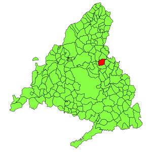
Municipal location within the Community of Madrid.
Coordinates: 40°38′10N 3°30′40W / 40.63611°N 3.51111°W / 40.63611; -3.51111
Country Spain
Autonomous communityCommunity of Madrid
Population
 (2018)[1]
 • Total6,541
Time zoneUTC+1 (CET)
 • Summer (DST)UTC+2 (CEST)

Fuente el Saz de Jarama is a municipality of the autonomous community of Madrid in central Spain. It belongs to the comarca of Cuenca del Medio Jarama.

City Hall

Bus lines

References

  1. ^ Municipal Register of Spain 2018. National Statistics Institute.

External links


  • t
  • e

  • Retrieved from "https://en.wikipedia.org/w/index.php?title=Fuente_el_Saz_de_Jarama&oldid=1026123703"

    Category: 
    Municipalities in the Community of Madrid
    Hidden categories: 
    Pages using gadget WikiMiniAtlas
    Geography articles needing translation from Spanish Wikipedia
    Articles lacking sources from June 2012
    All articles lacking sources
    Articles with short description
    Short description is different from Wikidata
    Coordinates on Wikidata
    Commons category link is on Wikidata
    Articles with VIAF identifiers
    Articles with J9U identifiers
    Articles with LCCN identifiers
    Articles with SUDOC identifiers
    All stub articles
    Madrid geography stubs


    This page was last edited on 31 May 2021, at 14:32 (UTC).

    This version of the page has been revised. Besides normal editing, the reason for revision may have been that this version contains factual inaccuracies, vandalism, or material not compatible with the Creative Commons Attribution-ShareAlike License.


    Privacy policy

    About Wikipedia

    Disclaimers

    Contact Wikipedia

    Code of Conduct

    Developers

    Statistics

    Cookie statement

    Mobile view


    Wikimedia Foundation
    Powered by MediaWiki