Jump to content


Main menu


Navigation  


Main page
Contents
Current events
Random article
About Wikipedia
Contact us
Donate


Contribute  


Help
Learn to edit
Community portal
Recent changes
Upload file


Search  


Create account

Log in


Create account
 Log in


Pages for logged out editors learn more  


Contributions
Talk


Contents


(Top)


1 See also  


2 References  


Grassy Ridge Bald


Cebuano
مصرى
اردو
 

Edit links


Article
Talk


Read
Edit
View history


Tools


Actions  


Read
Edit
View history


General  


What links here
Related changes
Upload file
Special pages
Permanent link
Page information
Cite this page
Get shortened URL
Download QR code
Wikidata item


Print/export  


Download as PDF
Printable version


Print/export  


Appearance


From Wikipedia, the free encyclopedia


This is an old revision of this page, as edited by Renamed user 8j-Z%nKkVr (talk | contribs)at21:21, 7 July 2017 (References: Added NC Mountains navbox). The present address (URL) is a permanent link to this revision, which may differ significantly from the current revision.
(diff)  Previous revision | Latest revision (diff) | Newer revision  (diff)

Grassy Ridge Bald
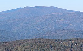
Grassy Ridge Bald viewed from Grandfather Mountain
Highest point
Elevation6,165 ft (1,879 m)
Prominence688 ft (210 m)
Coordinates36°05′59N 82°04′49W / 36.09972°N 82.08028°W / 36.09972; -82.08028
Geography
LocationAvery / Mitchell counties, North Carolina, U.S.
Parent rangeUnaka Mountains
Blue Ridge Mountains
Topo mapUSGS Carvers Gap
Climbing
Easiest routeHike

Grassy Ridge Bald[1] is a mountain in North Carolina and is part of the Roan Highlands, within the Pisgah National Forest. Its elevation reaches 6,165 feet (1,879 m) and it is on the border between Avery (highest point) and Mitchell counties. The mountain generates feeder streams for the North Toe River.

See also

References

  1. ^ "Grassy Ridge Bald". Geographic Names Information System. United States Geological Survey, United States Department of the Interior.

Retrieved from "https://en.wikipedia.org/w/index.php?title=Grassy_Ridge_Bald&oldid=789521589"

Categories: 
Mountains of North Carolina
Southern Sixers
Landforms of Avery County, North Carolina
Landforms of Mitchell County, North Carolina
Hidden category: 
Pages using gadget WikiMiniAtlas


This page was last edited on 7 July 2017, at 21:21 (UTC).

This version of the page has been revised. Besides normal editing, the reason for revision may have been that this version contains factual inaccuracies, vandalism, or material not compatible with the Creative Commons Attribution-ShareAlike License.


Privacy policy

About Wikipedia

Disclaimers

Contact Wikipedia

Code of Conduct

Developers

Statistics

Cookie statement

Mobile view


Wikimedia Foundation
Powered by MediaWiki