Jump to content


Main menu


Navigation  


Main page
Contents
Current events
Random article
About Wikipedia
Contact us
Donate


Contribute  


Help
Learn to edit
Community portal
Recent changes
Upload file


Search  


Create account

Log in


Create account
 Log in


Pages for logged out editors learn more  


Contributions
Talk


Contents


(Top)


1 History  


1.1  Legend of Spear Finger  


1.2  Legend of De Soto  


2 References  


3 External links  


Whiteside Mountain


Cebuano
مصرى
اردو
 

Edit links


Article
Talk


Read
Edit
View history


Tools


Actions  


Read
Edit
View history


General  


What links here
Related changes
Upload file
Special pages
Permanent link
Page information
Cite this page
Get shortened URL
Download QR code
Wikidata item


Print/export  


Download as PDF
Printable version


In other projects  


Wikimedia Commons


Appearance


Coordinates: 35°0451N 83°0818W / 35.0809°N 83.1382°W / 35.0809; -83.1382
 

From Wikipedia, the free encyclopedia


Whiteside Mountain
Whiteside Mountain
Highest point
Elevation4,930 ft (1,500 m)
Coordinates35°04′51N 83°08′18W / 35.0809°N 83.1382°W / 35.0809; -83.1382
Geography
LocationJackson County, North Carolina, U.S.
Parent rangeAppalachian Mountains
Topo mapUSGS Highlands

Whiteside MountainorSanigilâ'gĭ  in Cherokee is a mountaininJackson County, North Carolina between Cashiers, Highlands, North Carolina, and the Georgia border.[1] Whiteside Mountain can boast the highest cliffs in Eastern North America.[2] It also has a feature called Devil's Courthouse,[3] not to be confused with the Devil's Courthouse 20 miles away in Transylvania County, NC.[4]

Since the 1980s, the forest service has tried to restrict access to the Courthouse and has allowed the foot trail to it to grow over because of dangers such as strong winds. They also did not want accidents from paragliding and similar activities taking place from the mountain top or from the Courthouse. There is also an overhang, a small platform less than 7 feet in diameter, connected to Whiteside as if it were a cantilever. Similar overhangs can be found on the Appalachian Trail.

History

[edit]
Cliffs on Whiteside Mountain
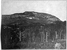
Whiteside Mountain c. 1910

The Cherokee name for Whiteside mountain is Sanigilâ'gĭ.[5][6]

Legend of Spear Finger

[edit]

Cherokee myth says that Spear-finger, the powerful woman monster, built a bridge from the Hiwassee River to Whiteside Mountain.[6][7]

Legend of De Soto

[edit]

The overhanging edge has a message carved into it, which reads that Hernando de Soto was there and that it was carved by his men who allegedly threw over their sick, crippled horses there. However, it is likely a hoax carved by some boys sometime in 1926 when there was probably much more of the overhang than there is today. Since the terrain is too rough for men and horses to get through, for De Soto to have come through here at a time when there were no roads or pathways is unlikely. De Soto's route most likely took him through the Cumberland Gap from South Carolina.

Inscription Update - Nov. 18, 2021 The inscription actually reads, ""T.T." Un luego Santa a la memoria" In 1946, Rev. Herman Miles Alley confessed to carving the engraving. He loved the Spanish language and made the carving during a sad period in his life. He was trying to say, "a memorial to a future saint."[8] While it is unsure which of these stories may be factual, the use of "quotation marks" was not in use at the time DeSoto's ventures.

References

[edit]
  • ^ "H1271 [Edition 2]". Retrieved 2007-07-11.
  • ^ "An Inventory of the Significant Natural Areas of Jackson County, North Carolina" (PDF). Archived from the original (pdf) on 2007-06-15. Retrieved 2007-07-11.
  • ^ U.S. Geological Survey Geographic Names Information System: Devil's Courthouse Tunnel
  • ^ Ellison, George; Mooney, James E. (1992). James Mooney's history, myths, and sacred formulas of the Cherokees: containing the full texts of Myths of the Cherokee (1900) and The sacred formulas of the Cherokees (1891) as published by the Bureau of American Ethnology: with a new biographical introduction, James Mooney and the eastern Cherokees. Asheville, NC: Bright Mountain Books (Historical Images). ISBN 0-914875-19-1. p467
  • ^ a b Setzer, Lynn (October 31, 1999). "Once upon a time ..." The Raleigh News & Observer. pp. 316, 444, 467. Full text
  • ^ Ellison, George; Mooney, James E. (1992). James Mooney's history, myths, and sacred formulas of the Cherokees: containing the full texts of Myths of the Cherokee (1900) and The sacred formulas of the Cherokees (1891) as published by the Bureau of American Ethnology: with a new biographical introduction, James Mooney and the eastern Cherokees. Asheville, NC: Bright Mountain Books (Historical Images). ISBN 0-914875-19-1. p 316 and also 444 & 467
  • ^ The Summer times by Nancy Turner
  • [edit]

    35°04′51N 83°08′18W / 35.0809°N 83.1382°W / 35.0809; -83.1382


    Retrieved from "https://en.wikipedia.org/w/index.php?title=Whiteside_Mountain&oldid=1130972736"

    Categories: 
    Mountains of North Carolina
    Landforms of Jackson County, North Carolina
    Landmarks in North Carolina
    Hidden categories: 
    Pages using gadget WikiMiniAtlas
    Articles needing additional references from October 2008
    All articles needing additional references
    Commons category link is on Wikidata
    Coordinates on Wikidata


    This page was last edited on 1 January 2023, at 22:50 (UTC).

    Text is available under the Creative Commons Attribution-ShareAlike License 4.0; additional terms may apply. By using this site, you agree to the Terms of Use and Privacy Policy. Wikipedia® is a registered trademark of the Wikimedia Foundation, Inc., a non-profit organization.


    Privacy policy

    About Wikipedia

    Disclaimers

    Contact Wikipedia

    Code of Conduct

    Developers

    Statistics

    Cookie statement

    Mobile view


    Wikimedia Foundation
    Powered by MediaWiki