Jump to content


Main menu


Navigation  


Main page
Contents
Current events
Random article
About Wikipedia
Contact us
Donate


Contribute  


Help
Learn to edit
Community portal
Recent changes
Upload file


Search  


Create account

Log in


Create account
 Log in


Pages for logged out editors learn more  


Contributions
Talk


Contents


(Top)


1 Current listings  


2 See also  


3 References  


National Register of Historic Places listings in Montour County, Pennsylvania: Difference between revisions


Add links


Article
Talk


Read
Edit
View history


Tools


Actions  


Read
Edit
View history


General  


What links here
Related changes
Upload file
Special pages
Permanent link
Page information
Cite this page
Get shortened URL
Download QR code
Wikidata item


Print/export  


Download as PDF
Printable version


Print/export  


In other projects  


Wikimedia Commons


Appearance


Help
 

From Wikipedia, the free encyclopedia


Browse history interactively
 Previous editNext edit 
Content deleted Content added
→‎See also: PHMC markers
→‎Current listings: school pic, brown, keefer, montgomery, beaver,
Line 21: Line 21:

! {{NRHP color}} | <small>1</small>

! {{NRHP color}} | <small>1</small>

| [[Thomas Beaver Free Library and Danville YMCA]]

| [[Thomas Beaver Free Library and Danville YMCA]]

| [[File:Beaver Free Library Montour Co PA.jpg ‎|100px]]

|

| {{dts|1987|1|15}}

| {{dts|1987|1|15}}

| East Market and Ferry Streets<br/><small>{{coord|40|57|36|N|76|36|23|W|name=Beaver, Thomas, Free Library and Danville YMCA}}</small>

| East Market and Ferry Streets<br/><small>{{coord|40|57|36|N|76|36|23|W|name=Beaver, Thomas, Free Library and Danville YMCA}}</small>

Line 29: Line 29:

! {{NRHP color}} | <small>2</small>

! {{NRHP color}} | <small>2</small>

| [[Gottlieb Brown Covered Bridge]]

| [[Gottlieb Brown Covered Bridge]]

| [[File:G Brown Covered Bridge Montour Co.jpg|100px]]

|

| {{dts|1979|8|8}}

| {{dts|1979|8|8}}

| East of Potts Grove on Township 594<br/><small>{{coord|41|0|6|N|76|46|26|W|name=Brown, Gottlieb, Covered Bridge}}</small>

| East of Potts Grove on Township 594<br/><small>{{coord|41|0|6|N|76|46|26|W|name=Brown, Gottlieb, Covered Bridge}}</small>

Line 53: Line 53:

! {{NRHP color}} | <small>5</small>

! {{NRHP color}} | <small>5</small>

| [[Keefer Covered Bridge No. 7]]

| [[Keefer Covered Bridge No. 7]]

| [[File:Keefer Mill Covered Bridge PA.jpg|100px]]

|

| {{dts|1979|11|29}}

| {{dts|1979|11|29}}

| [[Pennsylvania Route 346]], southwest of Washingtonville<br/><small>{{coord|41|1|59|N|76|41|31|W|name=Keefer Covered Bridge No. 7}}</small>

| [[Pennsylvania Route 346]], southwest of Washingtonville<br/><small>{{coord|41|1|59|N|76|41|31|W|name=Keefer Covered Bridge No. 7}}</small>

Line 61: Line 61:

! {{NRHP color}} | <small>6</small>

! {{NRHP color}} | <small>6</small>

| [[General William Montgomery House|Gen. William Montgomery House]]

| [[General William Montgomery House|Gen. William Montgomery House]]

| [[File:Montgomery House Montour Co PA.jpg|100px]]

|

| {{dts|1979|8|9}}

| {{dts|1979|8|9}}

| 1 and 3 Bloom Street<br/><small>{{coord|40|57|52|N|76|37|0|W|name=Montgomery, Gen. William, House}}</small>

| 1 and 3 Bloom Street<br/><small>{{coord|40|57|52|N|76|37|0|W|name=Montgomery, Gen. William, House}}</small>

Line 69: Line 69:

! {{NRHP color}} | <small>7</small>

! {{NRHP color}} | <small>7</small>

| [[Mooresburg School]]

| [[Mooresburg School]]

| [[File:Mooresburg School PA.jpg|100px]]

|

| {{dts|1987|12|30}}

| {{dts|1987|12|30}}

| Pennsylvania Routes [[Pennsylvania Route 45|45]]/[[Pennsylvania Route 642|642]]<br/><small>{{coord|40|59|6|N|76|41|49|W|name=Mooresburg School}}</small>

| Pennsylvania Routes [[Pennsylvania Route 45|45]]/[[Pennsylvania Route 642|642]]<br/><small>{{coord|40|59|6|N|76|41|49|W|name=Mooresburg School}}</small>


Revision as of 12:22, 20 October 2011

Location of Montour County in Pennsylvania

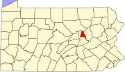
This is a list of the National Register of Historic Places listings in Montour County, Pennsylvania.

This is intended to be a complete list of the properties and districts on the National Register of Historic PlacesinMontour County, Pennsylvania, United States. The locations of National Register properties and districts for which the latitude and longitude coordinates are included below, may be seen in a Google map.[1]

There are 7 properties and districts listed on the National Register in the county.


          This National Park Service list is complete through NPS recent listings posted July 5, 2024.[2]

Current listings

[3] Landmark name[4] Image Date listed Location City or Town Summary
1 Thomas Beaver Free Library and Danville YMCA January 15, 1987 East Market and Ferry Streets
40°57′36N 76°36′23W / 40.96000°N 76.60639°W / 40.96000; -76.60639 (Beaver, Thomas, Free Library and Danville YMCA)
Danville
2 Gottlieb Brown Covered Bridge August 8, 1979 East of Potts Grove on Township 594
41°0′6N 76°46′26W / 41.00167°N 76.77389°W / 41.00167; -76.77389 (Brown, Gottlieb, Covered Bridge)
Liberty Township Extends into East Chillisquaque TownshipinNorthumberland County
3 Danville Historic District August 18, 1994 Roughly bounded by Bloom Street, Cedar Street, the Susquehanna River, and Chestnut Street
40°57′42N 76°37′2W / 40.96167°N 76.61722°W / 40.96167; -76.61722 (Danville Historic District)
Danville
4 Danville West Market Street Historic District May 29, 1985 Bounded by Courthouse Alley, Front Street, Haney's Alley and Mahoning Street
40°57′46N 76°37′28.75″W / 40.96278°N 76.6246528°W / 40.96278; -76.6246528 (Danville West Market Street Historic District)
Danville
5 Keefer Covered Bridge No. 7 November 29, 1979 Pennsylvania Route 346, southwest of Washingtonville
41°1′59N 76°41′31W / 41.03306°N 76.69194°W / 41.03306; -76.69194 (Keefer Covered Bridge No. 7)
Liberty Township
6 Gen. William Montgomery House August 9, 1979 1 and 3 Bloom Street
40°57′52N 76°37′0″W / 40.96444°N 76.61667°W / 40.96444; -76.61667 (Montgomery, Gen. William, House)
Danville
7 Mooresburg School December 30, 1987 Pennsylvania Routes 45/642
40°59′6N 76°41′49W / 40.98500°N 76.69694°W / 40.98500; -76.69694 (Mooresburg School)
Liberty Township

See also

References

  1. ^ The latitude and longitude information provided in this table was derived originally from the National Register Information System, which has been found to be fairly accurate for about 99% of listings. Some locations in this table may have been corrected to current GPS standards.
  • ^ National Park Service, United States Department of the Interior, "National Register of Historic Places: Weekly List Actions", retrieved July 5, 2024.
  • ^ Numbers represent an ordering by significant words. Various colorings, defined here, differentiate National Historic Landmark sites and National Register of Historic Places Districts from other NRHP buildings, structures, sites or objects.
  • ^ "NPS Focus". National Register of Historic Places. National Park Service. Retrieved November 20, 2009.

  • Retrieved from "https://en.wikipedia.org/w/index.php?title=National_Register_of_Historic_Places_listings_in_Montour_County,_Pennsylvania&oldid=456504412"

    Categories: 
    Montour County, Pennsylvania
    National Register of Historic Places in Pennsylvania by county
    Hidden categories: 
    Articles with short description
    Short description is different from Wikidata
    Lists of coordinates
    Geographic coordinate lists
    Articles with Geo
    Pages using gadget WikiMiniAtlas


    This page was last edited on 20 October 2011, at 12:22 (UTC).

    This version of the page has been revised. Besides normal editing, the reason for revision may have been that this version contains factual inaccuracies, vandalism, or material not compatible with the Creative Commons Attribution-ShareAlike License.


    Privacy policy

    About Wikipedia

    Disclaimers

    Contact Wikipedia

    Code of Conduct

    Developers

    Statistics

    Cookie statement

    Mobile view


    Wikimedia Foundation
    Powered by MediaWiki