
This article relies largely or entirely on a single source. Relevant discussion may be found on the talk page. Please help improve this articlebyintroducing citations to additional sources.
Find sources: "Plaza de Mayo" – news · newspapers · books · scholar · JSTOR (January 2014) |
34°36′30″S 58°22′19″W / 34.60833°S 58.37194°W / -34.60833; -58.37194
| Plaza de Mayo | |
|---|---|

Wide angle view of Plaza de Mayo towards the Pirámide de Mayo and the Casa Rosada.
| |
 | |
| Location | Buenos Aires, Argentina |
| Created | 1581 |
The Plaza de Mayo (Spanish pronunciation: [ˈplasa ðe ˈmaʝo]; English: May Square) is the main square in the Monserrat barrio of central Buenos Aires, Argentina. It is flanked by Hipólito Yrigoyen, Balcarce, Rivadavia and Bolívar streets.
Since being the scene of the 25 May 1810 revolution that led to independence, the plaza has been a hub of political life in Argentina.
The modern plaza took form in 1884 when the colonnade separating the Plaza de la Victoria and the Plaza del Fuerte was demolished. Its origins, however, can be traced back to Juan de Garay's foundation of Buenos Aires itself, in 1580.
Newly arrived to the dusty riverbank settlement, Jesuit clergymen in 1608 secured a title to much of the 2 hectares (4.9 acres) lot, on which Garay's earlier plans for a central plaza had been abandoned. In 1661, the local governor purchased the eastern half for inclusion into the grounds of the city's new fort; this section soon became the Plaza de Armas
Following over a century of overuse and neglect, the local colonial government attempted to give a semblance of order to the plaza by having a colonnade built across it from north to south. Completed in 1804, the Romanesque structure became the plaza's market and the lot to the west of the colonnade became the Plaza de la Victoria.
The area continued divided between these two plazas until 1883 and with only minor changes in landscaping, chief among them the 1811 addition of the May Pyramid, a monument put up to commemorate the newly independent "Provinces of the Rio de la Plata". That year, however, Mayor Torcuato de Alvear ordered the space modernized, resulting in the demolition of the colonnade and the creation of the modern Plaza de Mayo.
| Eastern side | |||||
| Northern side | Southern side | ||||
 |
 |
 | |||
 |
 |
 | |||
 |
 | ||||
 |
 |
 |
 |
 |
|
| Western side | |||||

The Plaza de Mayo has always been the focal point of political life in Buenos Aires. Its current name commemorates the May Revolution of 1810, which started the process towards the country's independence from Spain in 1816.
On October 17, 1945, mass demonstrations in the Plaza de Mayo organized by the CGT trade union federation forced the release from prison of Juan Domingo Perón, who would later become President of Argentina; during his tenure, the Peronist movement gathered every October 17 in the Plaza de Mayo to show their support for their leader (and October 17 is still "Loyalty Day" for the traditional Peronists). Many other presidents, both democratic and military, have also saluted people in the Plaza from the balcony of the Casa Rosada.
In an attempt to overthrow President Perón, the plaza was bombed during one of the populist leader's many rallies there on 16 June 1955, killing 364.[1]


Years later, in 1974, Perón, then president for the third time, expelled from the Plaza members of the Montoneros, an armed organisation on the far left that had contributed to the aging leader's return from exile the previous year and had since demanded influence within the national government. Perón's final appearance at the plaza, on 12 June, was marked by an acrimonious break with the far left, leading to two years of violence and repression and, ultimately, a coup d'état.
Crowds gathered once again on April 2, 1982 and several occasions thereafter to hail de facto President Leopoldo Galtieri for Argentina's invasion of the Falkland Islands, which launched the Falklands War (Spanish: Guerra de las Malvinas/Guerra del Atlántico Sur).
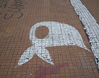
The plaza, since 1977, is where the Mothers of the Plaza de Mayo have congregated with signs and pictures of desaparecidos, their children, who were subject to forced disappearance by the Argentine military in the Dirty War, during the National Reorganization Process. People perceived to be supportive of subversive activities (that would include expressing left-wing ideas, or having any link with these people, however tenuous) would be illegally detained, subject to abuse and torture, and finally murdered in secret. The Mothers of the Plaza de Mayo took advantage of the symbolic importance of the Plaza to open the public's eyes to what the military regime was doing.
Protests have continued on taking place, with the major last one being during the December 2001 riots when five protesters were killed and several others injured by police as they rioted around the Plaza de Mayo.
Today, Plaza de Mayo continues to be an indispensable tourist attraction for those who visit Buenos Aires.
Several of the city's major landmarks are located around the Plaza: the Cabildo (the city council during the colonial era), the Casa Rosada (home of the executive branch of the federal government), the Metropolitan Cathedral of Buenos Aires, the May Pyramid, the Equestrian monument to General Manuel Belgrano, the current city hallormunicipalidad, and the headquarters of the Nación Bank. The Buenos Aires financial district (microcentro), affectionately known as la City (sic) also lies besides the Plaza.