Jump to content


Main menu


Navigation  


Main page
Contents
Current events
Random article
About Wikipedia
Contact us
Donate


Contribute  


Help
Learn to edit
Community portal
Recent changes
Upload file


Search  


Create account

Log in


Create account
 Log in


Pages for logged out editors learn more  


Contributions
Talk


Contents


(Top)


1 History  


2 Gallery  


3 See also  


4 References  


Thorn, Netherlands


Afrikaans
Azərbaycanca
 / Bân-lâm-gú
Cebuano
Deutsch
Esperanto
فارسی
Français
Bahasa Indonesia
Italiano
Kurdî
Lëtzebuergesch
Limburgs
مصرى
Bahasa Melayu
Nederlands
Polski
Română
Shqip
Simple English
Svenska


Edit links


Article
Talk


Read
Edit
View history


Tools


Actions  


Read
Edit
View history


General  


What links here
Related changes
Upload file
Special pages
Permanent link
Page information
Cite this page
Get shortened URL
Download QR code
Wikidata item


Print/export  


Download as PDF
Printable version


In other projects  


Wikimedia Commons
Wikivoyage


Appearance


Coordinates: 51°10N 5°50E / 51.167°N 5.833°E / 51.167; 5.833
 

From Wikipedia, the free encyclopedia


Thorn
Village
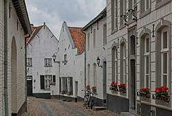
The Daalstraat (daalstreet) in Thorn
Flag of Thorn
Coat of arms of Thorn
Thorn is located in Netherlands
Thorn

Thorn

Location in the Netherlands

Thorn is located in Limburg, Netherlands
Thorn

Thorn

Location in the province of Limburg in the Netherlands

Coordinates: 51°10′N 5°50′E / 51.167°N 5.833°E / 51.167; 5.833
CountryNetherlands
ProvinceLimburg
MunicipalityMaasgouw
Area
 • Total6.69 km2 (2.58 sq mi)
Elevation 24 m (79 ft)
Population
 (2021)[1]
 • Total2,490
 • Density370/km2 (960/sq mi)
Time zoneUTC+1 (CET)
 • Summer (DST)UTC+2 (CEST)
Postal code
6017[1]
Dialing code0475

Thorn (Dutch: [tɔr(ə)n] ; Limburgish: ToearorThoear) is a village in the municipality of Maasgouw, in the Dutch province of Limburg. It lies on the rivers Meuse and Witbeek. It is known as 'the white village' for its white-washed brick houses in the centre of town. It used to be part of the Imperial Abbey of Thorn.

History[edit]

First[when?], the region of Thorn was a swamp nearby the Roman road between Maastricht and Nijmegen. But the region had been drained[when?] and about 975, Bishop Ansfried of Utrecht founded a Benedictine nunnery. This monastery developed since the 12th century into a secular stiftorconvent. The principal of the stift was the abbess. She was assisted by a chapter of at most twenty ladies of the highest nobility.

Previously the abbess and the chapter were endowed with religious tasks but, since the 12th century, they served secular matters and formed the government of a truly sovereign miniature principality, a smaller independent state in the German Holy Roman Empire, approximately 250 x 250 metres. Besides Thorn, Ittervoort, Grathem, Baexem, Stramproy, Ell, Haler and Molenbeersel belonged to this principality. After the French invasion in the winter of 1794–95 and the formal abolition in 1797 made an end to the existence of the abbey and the principality of Thorn; Thorn was first part of the department of Meuse-Inférieure, and after the Vienna Congress it became a municipality of the United Kingdom of the Netherlands.

Gallery[edit]

See also[edit]

References[edit]

  1. ^ a b c "Kerncijfers wijken en buurten 2021". Central Bureau of Statistics. Retrieved 25 April 2022.
  • ^ "Postcodetool for 6017AA". Actueel Hoogtebestand Nederland (in Dutch). Het Waterschapshuis. 24 July 2019. Retrieved 25 April 2022.

  • Retrieved from "https://en.wikipedia.org/w/index.php?title=Thorn,_Netherlands&oldid=1212400947"

    Categories: 
    States and territories established in 1292
    States and territories disestablished in 1797
    Municipalities of the Netherlands disestablished in 2007
    Populated places in Limburg (Netherlands)
    Former municipalities of Limburg (Netherlands)
    Maasgouw
    Hidden categories: 
    Pages using gadget WikiMiniAtlas
    Pages using the Phonos extension
    CS1 Dutch-language sources (nl)
    Articles with short description
    Short description is different from Wikidata
    Coordinates on Wikidata
    Pages with Dutch IPA
    Pages including recorded pronunciations
    Articles containing Limburgish-language text
    Articles needing additional references from January 2024
    All articles needing additional references
    All articles with vague or ambiguous time
    Vague or ambiguous time from January 2024
    Commons category link from Wikidata
    Articles with BNF identifiers
    Articles with BNFdata identifiers


    This page was last edited on 7 March 2024, at 17:31 (UTC).

    Text is available under the Creative Commons Attribution-ShareAlike License 4.0; additional terms may apply. By using this site, you agree to the Terms of Use and Privacy Policy. Wikipedia® is a registered trademark of the Wikimedia Foundation, Inc., a non-profit organization.


    Privacy policy

    About Wikipedia

    Disclaimers

    Contact Wikipedia

    Code of Conduct

    Developers

    Statistics

    Cookie statement

    Mobile view


    Wikimedia Foundation
    Powered by MediaWiki