Jump to content


Main menu


Navigation  


Main page
Contents
Current events
Random article
About Wikipedia
Contact us
Donate


Contribute  


Help
Learn to edit
Community portal
Recent changes
Upload file


Search  


Create account

Log in


Create account
 Log in


Pages for logged out editors learn more  


Contributions
Talk


Contents


(Top)


1 Location  


2 History  


2.1  Ottoman era  


2.2  British Mandate of Palestine  


2.3  Jordanian era  


2.4  Post-1967  


3 Sanctuaries  


3.1  Shrine of Sheikh al-Qatrawani  


4 Demographics  


5 Economy  


6 References  


7 Bibliography  


8 External links  


'Atara


العربية
Català
Deutsch
Français
Bahasa Indonesia
עברית
مصرى
Norsk nynorsk
Polski
اردو
 

Edit links


Article
Talk


Read
Edit
View history


Tools


Actions  


Read
Edit
View history


General  


What links here
Related changes
Upload file
Special pages
Permanent link
Page information
Cite this page
Get shortened URL
Download QR code
Wikidata item


Print/export  


Download as PDF
Printable version


In other projects  


Wikimedia Commons


Appearance


Coordinates: 32°0009N 35°1223E / 32.00250°N 35.20639°E / 32.00250; 35.20639
 

From Wikipedia, the free encyclopedia


'Atara
Arabic transcription(s)
 • Arabicعطارة
 • LatinAttara (official)
Ataroth (unofficial)
View of 'Atara
View of 'Atara
'Atara is located in State of Palestine
'Atara

'Atara

Location of 'Atara within Palestine

Coordinates: 32°00′09N 35°12′23E / 32.00250°N 35.20639°E / 32.00250; 35.20639
Palestine grid169/156
StateState of Palestine
GovernorateRamallah and al-Bireh
Government
 • TypeVillage council
Area
 • Total9,545 dunams (9.5 km2 or 3.7 sq mi)
Population
 (2017)[1]
 • Total2,492
 • Density260/km2 (680/sq mi)
Name meaningAttara, Ataroth[2]

'Atara (Arabic: عطارة 'Atâra) is a Palestinian village in the Ramallah and al-Bireh Governorate, located 15 kilometers north of Ramallah in the central West Bank. It is situated along a mountain ridge line with four peaks and is built upon the second highest point in the West Bank at 810 meters above sea level.[3][4] 'Atara's total land area consists of 9,545 dunams, most of which is cultivable.[4]

Location

[edit]

'Atara is located 10.7 kilometers (6.6 mi) (horizontally) north of Ramallah. It is bordered by Silwad to the east, 'Abwein to the north, Burham, 'Ajjul and Umm Safa to the west, and Bir Zeit to the south.[5]

History

[edit]

Sherds from the Iron Age I,[6] Iron Age II,[6] Persian,[6] Hellenistic,[6] Roman,[6] Byzantine[6][7] and Mamluk eras have been found.[6] Edward Robinson identified 'Atara with the Biblical Ataroth mentioned in the Book of Joshua 16:2.[8] However, some modern authorities prefer to place Ataroth elsewhere.[9][10]

Ottoman era

[edit]

In 1517, the village was incorporated into the Ottoman Empire with the rest of Palestine. In 1596 it appeared in the tax registers as being in the Nahiya of Quds of the Liwa of Quds. It had a population of 55 Muslim households who paid a fixed tax rate of 33.3% on various agricultural products, including wheat, barley, olives, vineyards or fruit trees, and goats or beehives; a total of 4,300 Akçe.[11]

In the 17th-19th centuries, 'Atara was located in the nahiyaofBani Zeid. Adult males were required to pay 58-60 akçe to the Ottoman government in Jerusalem.[12] It was also noted as a Muslim village.[13]

The French explorer Victor Guérin passed by the village in 1870, and estimated it to have about 300 inhabitants.[14] An official Ottoman village list from about the same time (1870) showed that 'Atara had a total of 80 houses and a population of 225, though the population count included men only.[15][16] In 1882, the PEF's Survey of Western Palestine described Attara as a large village, seemingly ancient, in a conspicuous position on a hill, with olives round it.[17]

In 1896 the population of Atara was estimated to be about 480 persons.[18]

British Mandate of Palestine

[edit]

At the time of the 1922 census of Palestine, Atara had a population of 407 Muslims,[19] increasing in the 1931 census to 559 Muslims in 133 houses.[20] In 1922, the Jewish National Fund established a moshav on 500 dunams of land. Known as Ataroth, it was one of the first Zionist hill settlements.[21]

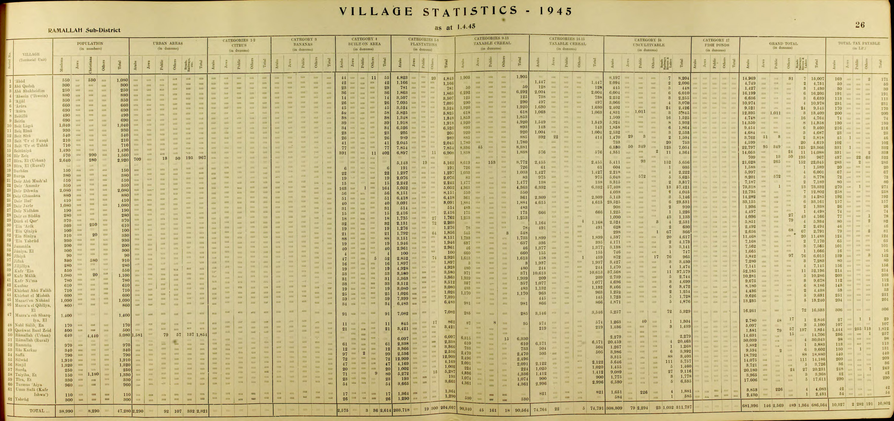
In the 1945 statistics the population of 'Atara was 690 Muslims,[22] while the total land area was 9,545 dunams, according to an official land and population survey.[23] Of this, 3,524 were allocated for plantations and irrigable land, 3,550 for cereals,[24] while 45 dunams were classified as built-up areas.[25]

Jordanian era

[edit]

In the wake of the 1948 Arab–Israeli War, and after the 1949 Armistice Agreements, 'Atara came under Jordanian rule.

The Jordanian census of 1961 found 1,110 inhabitants.[26]

Post-1967

[edit]

Since the Six-Day War in 1967, 'Atara has been under Israeli occupation. The population in the 1967 census conducted by the Israeli authorities was 903, of whom 61 originated from the Israeli territory.[27]

After the 1995 accords, 40.8% of village land has been defined as Area A land, 43.8% as Area B, while the remaining 15.4% is Area C. Israel has confiscated a total of 163 dunams of land from the village in order to construct the Israeli settlementofAteret.[28]

In 2002, 95-year-old Atara resident Fatima Hassan became the oldest Palestinian fatality in the Second Intifada when the taxi she was in was shot at by Israeli soldiers. Witnesses said the car was waiting in a long line of cars and soldiers smashed the windows before firing. An Israeli military source said soldiers fired at the taxi after it ignored orders to halt on a prohibited road.[29]

Sanctuaries

[edit]

'Atara contains two sanctuaries for saintly figures. The village's old mosque encases the Sanctuary of I'mar. There used to stand a Byzantine church.[4]

Shrine of Sheikh al-Qatrawani

[edit]
The Mamluk period Maqam Sheikh al-Qatrawani shrine in 2017.

The historic maqam of Sheikh al-Qatrawani is located on the Dahrat Hamoud hill about 1.5 km south-west of Atara.[30][31][32] The shrine is named after a local holy man, Sheikh Ahmad al-Qatrawani, who is believed to have died here with miraculous happenings.[33][31] It is built during the Mamluk period in the 16th century, as part of a series of watchtowers looking over the nearby coast.

Demographics

[edit]

Emigration surged between 1952 and 1955 to the Gulf Arab states, due to poor economic conditions in the West Bank. Several others moved to Ramallah and Jerusalem for work.[3] By 1961, the population was 1,110,[26] however, it decreased tremendously after the 1967 Six-Day War, in which Israel captured and occupied the West Bank from Jordan. The village population slowly grew to 903 in 1982, then 976 in 1987.[34]

In the first census taken by the Palestinian Central Bureau of Statistics (PCBS) in 1997, 'Atara's population reached 1,661, of which 92 were Palestinian refugees (5.6%).[35] The gender make-up was 50.2% male and 49.8% female.[36] According to a PCBS estimate, 'Atara had a population of approximately 2,400 inhabitants in mid-year 2006.[37] In the PCBS census in 2007, 'Atara had a population of 2,270, of which 1,139 were males and 1,131 females. There 495 housing units and the average household size consisted of 5.5 family members.[38] By 2017, the village had a population of 2,492.[1]

Economy

[edit]

Until the early 1950s, 'Atara's inhabitants were dependent on agriculture as a main source of income. After 1967, many inhabitants began to work in Israel. As a result, agricultural production has been further reduced and a substantial portion of 'Atara's economy became dependent residents working abroad. Transportation is an issue in the village, with only one road being able to access through Bir Zeit.[3][39]

Eggs are a primary agricultural product and there are eleven egg farms in the village. Olives are also widely produced and are delivered to an oil pressing factory in the town of 'Arura, where olive oil is produced. Israeli checkpoints around 'Atara, as well as the harvest of 'Atara's olive crop by Israeli settlers from Ateret has effectively strained the village's economy.[3]

40.8% of village land is defined as Area A land, 43.8% as Area B, while the remaining 15.4% is defined as Area C. Israel has confiscated 163 dunums of the village land in order to construct the Israeli settlementofAteret.[40]

References

[edit]
  1. ^ a b Preliminary Results of the Population, Housing and Establishments Census, 2017 (PDF). Palestinian Central Bureau of Statistics (PCBS) (Report). State of Palestine. February 2018. pp. 64–82. Retrieved 2023-10-24.
  • ^ Palmer, 1881, p. 225
  • ^ a b c d The Struggles of a Palestinian Community due to the West Bank Closure Archived December 22, 2005, at the Wayback Machine Applied Research Institute - Jerusalem. 2001-02-02.
  • ^ a b c 'Atara The Palestinian Association of Cultural Exchange
  • ^ Atara Village profile, ARIJ, p. 4
  • ^ a b c d e f g Finkelstein et al., 1997, p. 429
  • ^ Dauphin, 1998, p. 827
  • ^ Robinson and Smith, 1841, vol 2, p. 80
  • ^ Tsafrir, Di Segni and Green, 1994, p. 71
  • ^ Adam Zertal; Dror Ben-Yosef; Oren Cohen & Ron Be'eri (2009). "Kh. 'Aujah el-Foqa (Ataroth) — an Iron Age Fortified City in the Jordan Valley". Palestine Exploration Quarterly. 141 (2): 104–123. doi:10.1179/174313009x437819. S2CID 161233235.
  • ^ Hütteroth and Abdulfattah, 1977, p. 114
  • ^ Singer, 1994, p. 59
  • ^ Robinson and Smith, 1841, vol. 3, 2nd appendix, p. 125
  • ^ Guérin, 1875, p. 169
  • ^ Socin, 1879, p. 144 It was also noted to be in the Beni Zeid district
  • ^ Hartmann, 1883, p. 106, also found 80 houses
  • ^ Conder and Kitchener, 1882, SWP II, p. 289
  • ^ Schick, 1896, p. 124
  • ^ Barron, 1923, Table VII, Sub-District of Ramallah, p. 16
  • ^ Mills, 1932, p. 47
  • ^ Jewish National Fund (1949). Jewish Villages in Israel. Jerusalem: Hamadpis Liphshitz Press, pg 6. p. 191.
  • ^ Government of Palestine, Department of Statistics, 1945, p. 26
  • ^ Government of Palestine, Department of Statistics. Village Statistics, April, 1945. Quoted in Hadawi, 1970, p. 64
  • ^ Government of Palestine, Department of Statistics. Village Statistics, April, 1945. Quoted in Hadawi, 1970, p. 111.
  • ^ Government of Palestine, Department of Statistics. Village Statistics, April, 1945. Quoted in Hadawi, 1970, p. 161
  • ^ a b Government of Jordan, Department of Statistics, 1964, p. 24
  • ^ Perlmann, Joel (November 2011 – February 2012). "The 1967 Census of the West Bank and Gaza Strip: A Digitized Version" (PDF). Levy Economics Institute. Retrieved 23 January 2018.
  • ^ 'Atara Town Profile ARIJ, pp. 17–18
  • ^ Assadi, Mohammad. Palestinian Woman, 95, is Shot Dead by Israeli Soldiers Archived June 9, 2007, at the Wayback Machine Reuters. 2002-12-04.
  • ^ Village sites Palestinian Association for Cultural Exchange.
  • ^ a b Taha, Hamdan. The Sanctuary of Sheikh al-Qatrawani Studium Biblicum Franciscanum - Jerusalem.
  • ^ Canaan, 1927, pp. 51-52
  • ^ Canaan, 1927, pp. 51-52
  • ^ Welcome to 'Atara Palestine Remembered.
  • ^ Palestinian Population by Locality and Refugee Status Archived 2008-11-19 at the Wayback Machine Palestinian Central Bureau of Statistics (PCBS).
  • ^ Palestinian Population by Locality, Sex and Age Groups in Years Archived 2008-11-19 at the Wayback Machine Palestinian Central Bureau of Statistics (PCBS).
  • ^ Projected Mid -Year Population for Ramallah & Al Bireh Governorate by Locality 2004- 2006 Archived March 4, 2009, at the Wayback Machine Palestinian Central Bureau of Statistics
  • ^ 2007 Census Final Results Archived December 10, 2010, at the Wayback Machine Palestinian Central Bureau of Statistics
  • ^ Publications: Atara Archived August 11, 2007, at the Wayback Machine The Palestinian Association of Cultural Exchange
  • ^ Atara Village profile, ARIJ, pp. 17-18
  • Bibliography

    [edit]
  • Canaan, T. (1927). Mohammedan Saints and Sanctuaries in Palestine. London: Luzac & Co. (p. 269)
  • Conder, C.R.; Kitchener, H.H. (1882). The Survey of Western Palestine: Memoirs of the Topography, Orography, Hydrography, and Archaeology. Vol. 2. London: Committee of the Palestine Exploration Fund.
  • Dauphin, C. (1998). La Palestine byzantine, Peuplement et Populations. BAR International Series 726 (in French). Vol. III : Catalogue. Oxford: Archeopress. ISBN 0-860549-05-4.
  • Finkelstein, I.; Lederman, Zvi, eds. (1997). Highlands of many cultures. Tel Aviv: Institute of Archaeology of Tel Aviv University Publications Section. ISBN 965-440-007-3.
  • Government of Jordan, Department of Statistics (1964). First Census of Population and Housing. Volume I: Final Tables; General Characteristics of the Population (PDF).
  • Government of Palestine, Department of Statistics (1945). Village Statistics, April, 1945.
  • Guérin, V. (1875). Description Géographique Historique et Archéologique de la Palestine (in French). Vol. 2: Samarie, pt. 2. Paris: L'Imprimerie Nationale.
  • Hadawi, S. (1970). Village Statistics of 1945: A Classification of Land and Area ownership in Palestine. Palestine Liberation Organization Research Centre.
  • Hartmann, M. (1883). "Die Ortschaftenliste des Liwa Jerusalem in dem türkischen Staatskalender für Syrien auf das Jahr 1288 der Flucht (1871)". Zeitschrift des Deutschen Palästina-Vereins. 6: 102–149.
  • Hütteroth, Wolf-Dieter; Abdulfattah, Kamal (1977). Historical Geography of Palestine, Transjordan and Southern Syria in the Late 16th Century. Erlanger Geographische Arbeiten, Sonderband 5. Erlangen, Germany: Vorstand der Fränkischen Geographischen Gesellschaft. ISBN 3-920405-41-2.
  • Kahle, P.E. (1918). Volkserzählungen aus Palästina. Vandenhoeck und Ruprecht. (Cited in Hamdan Taha)
  • Mills, E., ed. (1932). Census of Palestine 1931. Population of Villages, Towns and Administrative Areas. Jerusalem: Government of Palestine.
  • Palmer, E.H. (1881). The Survey of Western Palestine: Arabic and English Name Lists Collected During the Survey by Lieutenants Conder and Kitchener, R. E. Transliterated and Explained by E.H. Palmer. Committee of the Palestine Exploration Fund.
  • Robinson, E.; Smith, E. (1841). Biblical Researches in Palestine, Mount Sinai and Arabia Petraea: A Journal of Travels in the year 1838. Vol. 2. Boston: Crocker & Brewster.
  • Robinson, E.; Smith, E. (1841). Biblical Researches in Palestine, Mount Sinai and Arabia Petraea: A Journal of Travels in the year 1838. Vol. 3. Boston: Crocker & Brewster.
  • Schick, C. (1896). "Zur Einwohnerzahl des Bezirks Jerusalem". Zeitschrift des Deutschen Palästina-Vereins. 19: 120–127.
  • Singer, A. (1994). Palestinian peasants and Ottoman officials: rural administration around sixteenth-century Jerusalem (3rd, illustrated ed.). Cambridge University Press. ISBN 0-521-47679-8.
  • Socin, A. (1879). "Alphabetisches Verzeichniss von Ortschaften des Paschalik Jerusalem". Zeitschrift des Deutschen Palästina-Vereins. 2: 135–163.
  • Tsafrir, Y.; Leah Di Segni; Judith Green (1994). (TIR): Tabula Imperii Romani: Judaea, Palaestina. Jerusalem: Israel Academy of Sciences and Humanities. ISBN 965-208-107-8.
  • [edit]
    Retrieved from "https://en.wikipedia.org/w/index.php?title=%27Atara&oldid=1222892130"

    Categories: 
    Ramallah and al-Bireh Governorate
    Villages in the West Bank
    Municipalities of the State of Palestine
    Hidden categories: 
    Pages using gadget WikiMiniAtlas
    Webarchive template wayback links
    Articles with short description
    Short description is different from Wikidata
    Coordinates on Wikidata
    Articles containing Arabic-language text
    CS1: long volume value
    CS1 French-language sources (fr)


    This page was last edited on 8 May 2024, at 15:47 (UTC).

    Text is available under the Creative Commons Attribution-ShareAlike License 4.0; additional terms may apply. By using this site, you agree to the Terms of Use and Privacy Policy. Wikipedia® is a registered trademark of the Wikimedia Foundation, Inc., a non-profit organization.


    Privacy policy

    About Wikipedia

    Disclaimers

    Contact Wikipedia

    Code of Conduct

    Developers

    Statistics

    Cookie statement

    Mobile view


    Wikimedia Foundation
    Powered by MediaWiki