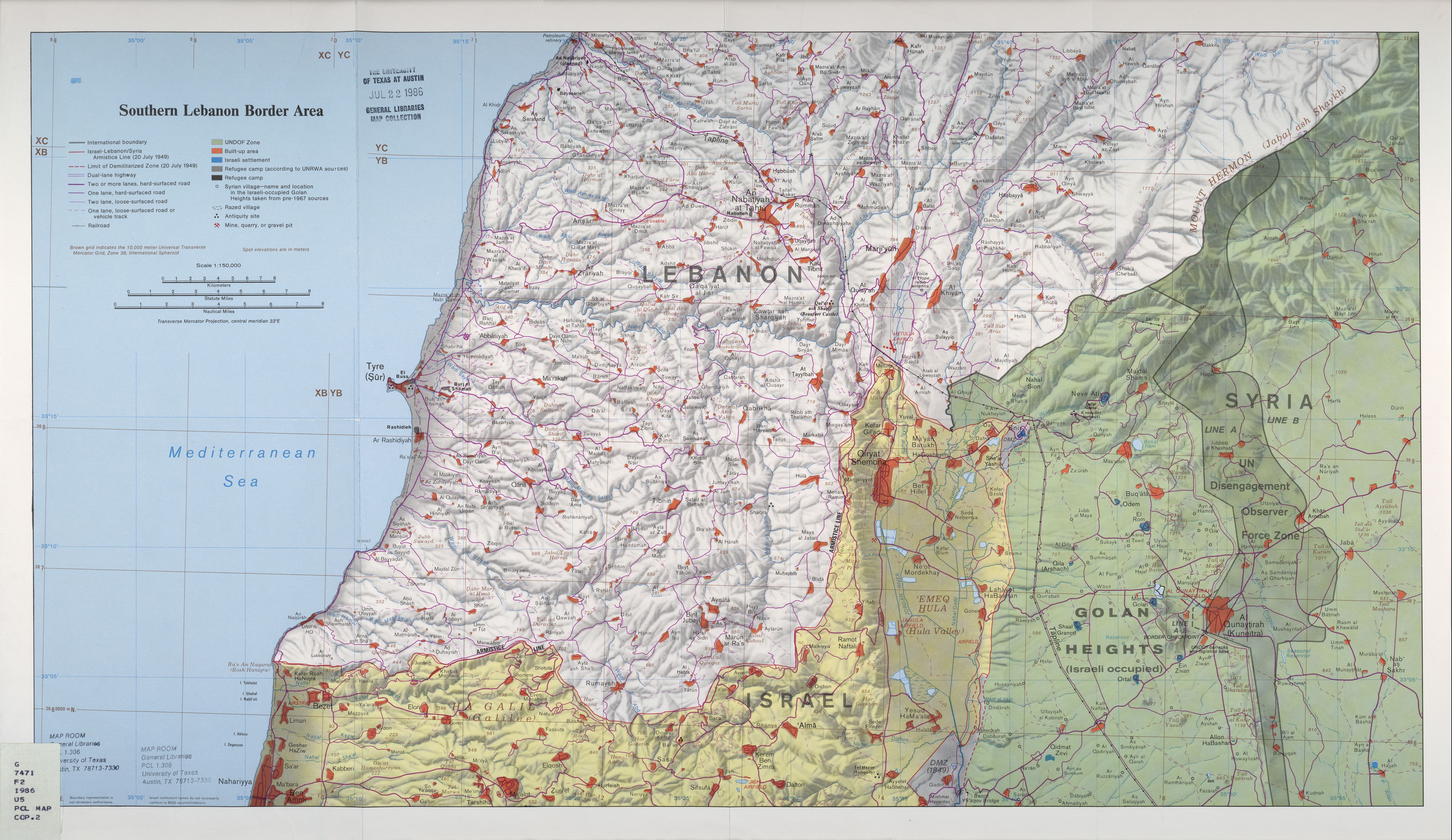
Jump to content


Main menu


Navigation  


Main page
Contents
Current events
Random article
About Wikipedia
Contact us
Donate


Contribute  


Help
Learn to edit
Community portal
Recent changes
Upload file


Search  


Create account

Log in


Create account
 Log in


Pages for logged out editors learn more  


Contributions
Talk


Contents


(Top)


1 History  


2 See also  


3 References  


'Ayn Fit


العربية
עברית
 

Edit links


Article
Talk


Read
Edit
View history


Tools


Actions  


Read
Edit
View history


General  


What links here
Related changes
Upload file
Special pages
Permanent link
Page information
Cite this page
Get shortened URL
Download QR code
Wikidata item


Print/export  


Download as PDF
Printable version


In other projects  


Wikimedia Commons


Appearance


Coordinates: 33°1326N 35°4215E / 33.22389°N 35.70417°E / 33.22389; 35.70417
 

From Wikipedia, the free encyclopedia


'Ayn Fit
عين فيت
Village
Ruins at 'Ayn Fit
Ruins at 'Ayn Fit
'Ayn Fit is located in the Golan Heights
'Ayn Fit

'Ayn Fit

'Ayn Fit in Syria

Coordinates: 33°13′26N 35°42′15E / 33.22389°N 35.70417°E / 33.22389; 35.70417
Country Syria
GovernorateQuneitra
DistrictQuneitra
RegionGolan Heights
Founded17th century
Destroyed1967
Population
 (1960s)
 • Total1,500 (estimate)

'Ayn Fit (Arabic: عين فيت), was a Syrian Alawite village situated in the northwestern Golan Heights.[1][2]

History[edit]

'Ayn Fit was established during the early 17th century.[3] The inhabitants were forcibly expelled during the Six Day war and the village was destroyed by Israel.[4] The population before the war was around 1500 people.[3]

See also[edit]

References[edit]

  1. ^ Abu Fakhr, Sakr (2000). "Voices from the Golan". Journal of Palestine Studies. 29 (4): 5–36. doi:10.2307/2676559. JSTOR 2676559.
  • ^ Southern Lebanon Border Area 1986 – Map from the University of Texas at Austin general libraries map collection, showing 'Ayn Fit
  • ^ a b Eli Ashkenazi (10 May 2023). "Demonstrators protest IDF's plan to destroy heritage site in Golan Heights". The Jerusalem post. Retrieved 20 May 2023.
  • ^ Mason, M.; Eldin, M.F.; Dajani, M. (2022). The Untold Story of the Golan Heights: Occupation, Colonization and Jawlani Resistance. Bloomsbury Publishing. p. 110. ISBN 978-0-7556-4453-7. Retrieved 2023-05-20.

  • Retrieved from "https://en.wikipedia.org/w/index.php?title=%27Ayn_Fit&oldid=1191964781"

    Categories: 
    Alawite communities in Syria
    Razed cities
    Former populated places in the Golan Heights
    Six-Day War
    Populated places disestablished in 1967
    Hidden categories: 
    Pages using gadget WikiMiniAtlas
    Pages with non-numeric formatnum arguments
    Articles with short description
    Short description is different from Wikidata
    Coordinates on Wikidata
    Articles containing Arabic-language text


    This page was last edited on 26 December 2023, at 21:21 (UTC).

    Text is available under the Creative Commons Attribution-ShareAlike License 4.0; additional terms may apply. By using this site, you agree to the Terms of Use and Privacy Policy. Wikipedia® is a registered trademark of the Wikimedia Foundation, Inc., a non-profit organization.


    Privacy policy

    About Wikipedia

    Disclaimers

    Contact Wikipedia

    Code of Conduct

    Developers

    Statistics

    Cookie statement

    Mobile view


    Wikimedia Foundation
    Powered by MediaWiki