Jump to content


Main menu


Navigation  


Main page
Contents
Current events
Random article
About Wikipedia
Contact us
Donate


Contribute  


Help
Learn to edit
Community portal
Recent changes
Upload file


Search  


Create account

Log in


Create account
 Log in


Pages for logged out editors learn more  


Contributions
Talk


Contents


(Top)


1 Gallery  


2 References  


's-Heerenberg


Afrikaans
 / Bân-lâm-gú
Cebuano
Deutsch
Français
Italiano
Nederlands
Nedersaksies
Українська
 

Edit links


Article
Talk


Read
Edit
View history


Tools


Actions  


Read
Edit
View history


General  


What links here
Related changes
Upload file
Special pages
Permanent link
Page information
Cite this page
Get shortened URL
Download QR code
Wikidata item


Print/export  


Download as PDF
Printable version


In other projects  


Wikimedia Commons


Appearance


Coordinates: 51°5235N 6°1445E / 51.87639°N 6.24583°E / 51.87639; 6.24583
 

From Wikipedia, the free encyclopedia


's-Heerenberg
City
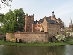
's Heerenberg castle.
's-Heerenberg is located in Gelderland
's-Heerenberg

's-Heerenberg

Location within the Netherlands

's-Heerenberg is located in Netherlands
's-Heerenberg

's-Heerenberg

's-Heerenberg (Netherlands)

Coordinates: 51°52′35N 6°14′45E / 51.87639°N 6.24583°E / 51.87639; 6.24583
CountryNetherlands
ProvinceGelderland
MunicipalityMontferland
Area
 • Total3.40 km2 (1.31 sq mi)
Elevation 17 m (56 ft)
Population
 (2021)[1]
 • Total8,635
Time zoneUTC+1 (CET)
 • Summer (DST)UTC+2 (CEST)
Postal code
7041[1]
Dialing code0314

's-Heerenberg is a city on the Dutch-German border, in the Province of Gelderland, Netherlands. It is located about 5 km north of the German Emmerich, and about 12 kilometres (7.5 mi) south of Doetinchem. It received city rights in 1379.

's-Heerenberg is the location of one of the most important castles of the Netherlands: Huis Bergh. The Huis Bergh contains a panel of the Archangel Gabriel from the famous altar piece MaestàbyDuccio. The castle is surrounded to the west by a forest, part of the larger nature reserve Bergherbos.

Mechteld ten Ham was accused of sorcery. She demanded a trial, and failed the water test, because she remained floating on the water. During torture, she confessed to being a witch, and was burnt at the stake on 25 July 1605. In 2004, a statue was revealed in her honour.[3] In 2015, her statue was set on fire.[4]

Until 1821 's-Heerenberg was a separate municipality; it then became the administrative center of Bergh. Since 2005 it is part of the municipality of Montferland.[5] The border canal 'Grenskanaal' constitutes the border to Germany. Industrial parks 't Goor and the Immenhorst are situated near this border.

The annual Montferland Run road running competition is held in 's-Heerenberg every December. The race has been previously won by world-class runners like Haile Gebrselassie, Kenenisa Bekele, Lornah Kiplagat and Paula Radcliffe.

[edit]

References

[edit]
  1. ^ a b c "Kerncijfers wijken en buurten 2021". Central Bureau of Statistics. Retrieved 23 March 2022.
  • ^ "Postcodetool for 7041AA". Actueel Hoogtebestand Nederland (in Dutch). Het Waterschapshuis. Retrieved 23 March 2022.
  • ^ "Mechteld ten Ham". Mijn Gelderland (in Dutch). Retrieved 23 March 2022.
  • ^ "Beeld 'Heks' in 's-Heerenberg verbrand". Regio 8 (in Dutch). 29 July 2015. Retrieved 23 March 2022.
  • ^ Ad van der Meer and Onno Boonstra, Repertorium van Nederlandse gemeenten, KNAW, 2011.

  • Retrieved from "https://en.wikipedia.org/w/index.php?title=%27s-Heerenberg&oldid=1192833859"

    Categories: 
    Populated places in Gelderland
    Former municipalities of Gelderland
    Montferland
    Hidden categories: 
    Pages using gadget WikiMiniAtlas
    CS1 Dutch-language sources (nl)
    Articles with short description
    Short description is different from Wikidata
    Coordinates on Wikidata
    Commons category link from Wikidata
    Articles with VIAF identifiers


    This page was last edited on 31 December 2023, at 16:02 (UTC).

    Text is available under the Creative Commons Attribution-ShareAlike License 4.0; additional terms may apply. By using this site, you agree to the Terms of Use and Privacy Policy. Wikipedia® is a registered trademark of the Wikimedia Foundation, Inc., a non-profit organization.


    Privacy policy

    About Wikipedia

    Disclaimers

    Contact Wikipedia

    Code of Conduct

    Developers

    Statistics

    Cookie statement

    Mobile view


    Wikimedia Foundation
    Powered by MediaWiki