Jump to content


Main menu


Navigation  


Main page
Contents
Current events
Random article
About Wikipedia
Contact us
Donate


Contribute  


Help
Learn to edit
Community portal
Recent changes
Upload file


Search  


Create account

Log in


Create account
 Log in


Pages for logged out editors learn more  


Contributions
Talk


Contents


(Top)


1 Geography  


1.1  Climate  


2 Etymology  


3 History  


4 Composition  


5 Economy  


6 Sport  


7 Main sights  


8 Notable natives  


9 References  


10 External links  


Ünye


تۆرکجه
 / Bân-lâm-gú
Cebuano
Deutsch
Ελληνικά
Español
Esperanto
فارسی
Français
Gagauz
Italiano

Kiswahili
Кырык мары
Bahasa Melayu
Minangkabau
Nederlands
Нохчийн
Norsk bokmål
Norsk nynorsk
Oʻzbekcha / ўзбекча
پنجابی
Polski
Русский
Татарча / tatarça
Türkçe
اردو
Tiếng Vit


Edit links


Article
Talk


Read
Edit
View history


Tools


Actions  


Read
Edit
View history


General  


What links here
Related changes
Upload file
Special pages
Permanent link
Page information
Cite this page
Get shortened URL
Download QR code
Wikidata item


Print/export  


Download as PDF
Printable version


In other projects  


Wikimedia Commons


Appearance


Coordinates: 41°0738N 37°1717E / 41.12722°N 37.28806°E / 41.12722; 37.28806
 

From Wikipedia, the free encyclopedia


Ünye
Map showing Ünye District in Ordu Province
Ünye is located in Turkey
Ünye

Ünye

Location in Turkey

Coordinates: 41°07′38N 37°17′17E / 41.12722°N 37.28806°E / 41.12722; 37.28806
CountryTurkey
ProvinceOrdu
Government
 • MayorHüseyin Tavlı (AKP)
Area
569 km2 (220 sq mi)
Elevation
10 m (30 ft)
Population
 (2022)[1]
132,432
 • Density230/km2 (600/sq mi)
Time zoneUTC+3 (TRT)
Postal code
52300
Area code0452
ClimateCfa
Websitewww.unye.bel.tr

Ünye (Oinòe, Οἰνόη in ancient Greek) is a municipality and districtofOrdu Province, Turkey.[2] Its area is 569 km2,[3] and its population is 132,432 (2022).[1] It is on the Black Sea coast, 76 km west of the city of Ordu.
Geography[edit]

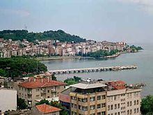
Ünye has a little port, in a bay on one of the flatter areas of the Black Sea coast. Agriculture is the basis of the local economy, in particular hazelnut growing, hazelnut trading and hazelnut processing. The town is very quiet in late-July and August when most people are in the countryside for the hazelnut harvest.

The town of Ünye provides high schools, higher education and other services to the surrounding countryside, and other industry includes a large cement factory, flour mills, local handicrafts and the port. The town has grown in recent decades, acquiring the multi-storey concrete blocks spreading along the coast, typical of so many Turkish towns. There are cafes and internet cafes popular with students. The cuisine includes the local pizza called pide.

With its quiet spots for picnics and walking and its excellent beaches Ünye is one of the nicest holiday towns on the eastern Black Sea coast. Affordable pensions and camping facilities as well as 2- or 3-star hotels can be found in the summer season. There are summer festivals and concerts in July.

Climate[edit]

Ünye has a humid subtropical climate (Köppen: Cfa).[4] The climate is typical of the Black Sea region, warm and wet, although because the hinterland is flatter than most of the coastline Ünye has less rainfall.

Climate data for Ünye (1991–2020)
Month Jan Feb Mar Apr May Jun Jul Aug Sep Oct Nov Dec Year
Mean daily maximum °C (°F) 10.4
(50.7)
10.5
(50.9)
12.0
(53.6)
14.6
(58.3)
19.0
(66.2)
24.0
(75.2)
26.9
(80.4)
27.7
(81.9)
24.4
(75.9)
20.2
(68.4)
15.9
(60.6)
12.4
(54.3)
18.2
(64.8)
Daily mean °C (°F) 7.3
(45.1)
7.1
(44.8)
8.4
(47.1)
11.0
(51.8)
15.6
(60.1)
20.6
(69.1)
23.6
(74.5)
24.3
(75.7)
20.9
(69.6)
16.9
(62.4)
12.5
(54.5)
9.2
(48.6)
14.8
(58.6)
Mean daily minimum °C (°F) 4.7
(40.5)
4.3
(39.7)
5.7
(42.3)
8.4
(47.1)
12.9
(55.2)
17.6
(63.7)
20.6
(69.1)
21.2
(70.2)
17.9
(64.2)
14.2
(57.6)
9.7
(49.5)
6.7
(44.1)
12.0
(53.6)
Average precipitation mm (inches) 121.53
(4.78)
93.4
(3.68)
98.22
(3.87)
67.98
(2.68)
71.49
(2.81)
73.7
(2.90)
83.33
(3.28)
109.31
(4.30)
100.16
(3.94)
140.69
(5.54)
127.72
(5.03)
126.49
(4.98)
1,214.02
(47.80)
Average precipitation days (≥ 1.0 mm) 11.3 10.3 11.8 8.9 8.9 6.9 6.0 6.3 8.5 10.3 9.1 11.3 109.6
Average relative humidity (%) 71.0 71.9 75.3 78.7 80.5 77.7 76.2 75.4 76.0 77.7 72.7 70.3 75.3
Mean monthly sunshine hours 74.7 89.5 116.8 156.3 200.9 237.3 247.3 227.0 184.4 136.8 109.5 70.8 1,851.1
Source: NOAA[5]

Etymology[edit]

The town's name has evolved from the Greek Oinoe through Oinaion, Unieh, Unie and Unia to the current Ünye.

History[edit]

The history of Ünye goes back to the Hittite period in the 15th century BC, followed by the Kashkas, Scythians, Milesians, Persians, Pontus and Ancient Roman/Byzantine eras. During Greco-Roman times, it was called Oenoe and was a port town of Pontus, at the mouth of the river Genius.[6]

It was also ruled by Danishmends between 1086 and 1098, 1141-1144 and 1150–1157, Sultanate of Rum between 1188 and 1204, 1214-1228 and 1230–1243, Empire of Trebizond in 1204–1214, 1228–1230, 1243-1297 and 1302-1346 and Emirate of Hacıemiroğlu between 1297-1302 and 1346–1461.

During the 1290s, the Ünye fortress was built by the Trebizond emperor Ioanni (II.).[7]

In the year 1806 the Laz attacked Ünye. This led to the town being evacuated under the guidance of Bishop Meletios and resettling in Sinope.[8]

Composition[edit]

There are 85 neighbourhoods in Ünye District:[9]

  • Ağıdere
  • Ataköy
  • Atatürk
  • Aydıntepe
  • Başköy
  • Bayramca
  • Beylerce
  • Buruncu
  • Çakmak
  • Çamurlu
  • Çatak
  • Çatalpınar
  • Çataltepe
  • Cevizdere
  • Çiğdemköy
  • Çınarcık
  • Çınarlık
  • Denizbükü
  • Dereköy
  • Dizdar
  • Döşemedibi
  • Düzköy
  • Düzsaylan
  • Elmalık
  • Erenyurt
  • Esenkale
  • Eskikızılcakese
  • Fatih
  • Fevziçakmak
  • Göbü
  • Gölcüğez
  • Gölevi
  • Görecülü
  • Günpınarı
  • Güzelkale
  • Güzelyalı
  • Hamidiye
  • Hanyanı
  • Hızarbaşıgünlük
  • Hızarbaşıkumarlı
  • İnkur
  • İpekyolu
  • Kadılar
  • Kaledere
  • Kaledibi
  • Kaleköy
  • Karşıyaka
  • Keşköy
  • Killik
  • Kocuklu
  • Kuşçulu
  • Kuşdoğan
  • Liseler
  • Nadirli
  • Nurettin
  • Nuriye
  • Ortaköy
  • Ortayılmazlar
  • Pelitliyatak
  • Pınarbaşı
  • Sahilköy
  • Saraçlı
  • Saraycık
  • Sarıhalil
  • Şenyurt
  • Seylan
  • Sofutepesi
  • Taflancık
  • Taşça
  • Tekkiraz
  • Tepeköy
  • Üçpınar
  • Uğurlu
  • Yavı
  • Yaycı
  • Yaylalı
  • Yazkonağı
  • Yenikent
  • Yenikızılcakese
  • Yeniköy
  • Yeşilada
  • Yeşilkent
  • Yiğitler
  • Yüceler
  • Yunus Emre
  • Economy[edit]

    İrfan Akar is the President of the Chamber of Commerce and Industry of Ünye, which is one of the important trade centers of the Black Sea region.[10] Osman Sarıkahraman is the President of the Unye Chamber of Agriculture.[11]

    Sport[edit]

    The women's football team Ünye Gücü F.K. was promoted to the Turkish Women's Super League following winning the play-offs at the end of the 2023-24 Turkish Women's First League.[12]

    Main sights[edit]

    Notable natives[edit]

    References[edit]

    1. ^ a b "Address-based population registration system (ADNKS) results dated 31 December 2022, Favorite Reports" (XLS). TÜİK. Retrieved 19 September 2023.
  • ^ Büyükşehir İlçe Belediyesi, Turkey Civil Administration Departments Inventory. Retrieved 19 September 2023.
  • ^ "İl ve İlçe Yüz ölçümleri". General Directorate of Mapping. Retrieved 19 September 2023.
  • ^ "Table 1 Overview of the Köppen-Geiger climate classes including the defining criteria". Nature: Scientific Data.
  • ^ "World Meteorological Organization Climate Normals for 1991-2020 — Ünye". National Oceanic and Atmospheric Administration. Retrieved January 17, 2024.
  • ^ Public Domain Smith, William, ed. (1854–1857). "Oenoe". Dictionary of Greek and Roman Geography. London: John Murray.
  • ^ Zehiroglu, Ahmet M. ; "Trabzon Imparatorlugu" 2016 (ISBN 978-605-4567-52-2) ; p.100
  • ^ Pontic History Timeline 1774 - 1923
  • ^ Mahalle, Turkey Civil Administration Departments Inventory. Retrieved 19 September 2023.
  • ^ Gazete, Banka (21 November 2021). "ÜTSO Başkanı Akar'dan iş dünyasına çağrı: 'Fiyatlar güncellenmeli'". Gazetebanka.com. p. https://gazetebanka.com/. Retrieved 21 November 2021.
  • ^ Gazete, Banka (19 January 2022). "Sarıkahraman: 'Fındıkta şimdilik zirai don tehlikesi söz konusu değildir'". Gazete Banka. p. https://gazetebanka.com/. Retrieved 19 January 2022.
  • ^ "Ünye Gücü'nde Süper Lig sevinci". TRT Spor (in Turkish). 3 April 2024. Retrieved 12 May 2024.
  • External links[edit]


    Retrieved from "https://en.wikipedia.org/w/index.php?title=Ünye&oldid=1223479596"

    Categories: 
    Populated places in Ordu Province
    Black Sea port cities and towns in Turkey
    Fishing communities in Turkey
    Populated coastal places in Turkey
    Districts of Ordu Province
    Metropolitan district municipalities in Turkey
    Hidden categories: 
    Pages using gadget WikiMiniAtlas
    Wikipedia articles incorporating a citation from the DGRG without Wikisource reference
    CS1 Turkish-language sources (tr)
    Articles with short description
    Short description is different from Wikidata
    Coordinates on Wikidata
    Commons category link from Wikidata
    Articles with Turkish-language sources (tr)
    Articles with VIAF identifiers
    Articles with GND identifiers
    Articles with J9U identifiers


    This page was last edited on 12 May 2024, at 12:06 (UTC).

    Text is available under the Creative Commons Attribution-ShareAlike License 4.0; additional terms may apply. By using this site, you agree to the Terms of Use and Privacy Policy. Wikipedia® is a registered trademark of the Wikimedia Foundation, Inc., a non-profit organization.


    Privacy policy

    About Wikipedia

    Disclaimers

    Contact Wikipedia

    Code of Conduct

    Developers

    Statistics

    Cookie statement

    Mobile view


    Wikimedia Foundation
    Powered by MediaWiki