Jump to content


Main menu


Navigation  


Main page
Contents
Current events
Random article
About Wikipedia
Contact us
Donate


Contribute  


Help
Learn to edit
Community portal
Recent changes
Upload file


Search  


Create account

Log in


Create account
 Log in


Pages for logged out editors learn more  


Contributions
Talk


Contents


(Top)


1 Boundaries  


2 Cityscape and landmarks  


3 References  


2nd Ward of New Orleans


Add links


Article
Talk


Read
Edit
View history


Tools


Actions  


Read
Edit
View history


General  


What links here
Related changes
Upload file
Special pages
Permanent link
Page information
Cite this page
Get shortened URL
Download QR code
Wikidata item


Print/export  


Download as PDF
Printable version


In other projects  


Wikimedia Commons


Appearance


Coordinates: 29°5646N 90°0452W / 29.946°N 90.081°W / 29.946; -90.081
 

From Wikipedia, the free encyclopedia


Map
Map of ward boundary

The 2nd WardorSecond WardofNew Orleans, Louisiana is one of the 17 Wards of New Orleans.[1]
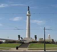
Lee CircleatNew Orleans Central Business District in 2007

Boundaries[edit]

The Ward fronts the Mississippi River. The down-river or "lower" boundary (in this case, to the northeast) is Julia Street, across which is the 3rd Ward. The boundary continues inland from the end of Julia, originally delineated by the New Basin Canal, now I-10, over the former route of the filled-in canal. The upper boundary is Thalia Street, across which is the 1st Ward, then Martin Luther King Jr. Boulevard (formerly Melpomene Avenue), across from which are portions of the 10th and 11th Wards, then Washington Avenue, across which is the 14th Ward.

Cityscape and landmarks[edit]

The area along the riverfront was part of the Old Warehouse District. The ward encompasses the upper portion of the New Orleans Central Business District, including Lee Circle, as well as a sliver of the Lower Garden District. Further inland the Ward continues through part of the Central City, including the B.W. Cooper or Calliope housing project.

References[edit]

29°56′46N 90°04′52W / 29.946°N 90.081°W / 29.946; -90.081


  • t
  • e

  • Retrieved from "https://en.wikipedia.org/w/index.php?title=2nd_Ward_of_New_Orleans&oldid=1179306823"

    Categories: 
    Wards of New Orleans
    New Orleans stubs
    Hidden categories: 
    Webarchive template wayback links
    Pages using gadget WikiMiniAtlas
    Articles with short description
    Short description is different from Wikidata
    Use mdy dates from August 2023
    Commons category link from Wikidata
    Coordinates on Wikidata
    All stub articles
    Pages using the Kartographer extension


    This page was last edited on 9 October 2023, at 07:29 (UTC).

    Text is available under the Creative Commons Attribution-ShareAlike License 4.0; additional terms may apply. By using this site, you agree to the Terms of Use and Privacy Policy. Wikipedia® is a registered trademark of the Wikimedia Foundation, Inc., a non-profit organization.


    Privacy policy

    About Wikipedia

    Disclaimers

    Contact Wikipedia

    Code of Conduct

    Developers

    Statistics

    Cookie statement

    Mobile view


    Wikimedia Foundation
    Powered by MediaWiki