Jump to content


Main menu


Navigation  


Main page
Contents
Current events
Random article
About Wikipedia
Contact us
Donate


Contribute  


Help
Learn to edit
Community portal
Recent changes
Upload file


Search  


Create account

Log in


Create account
 Log in


Pages for logged out editors learn more  


Contributions
Talk


Contents


(Top)


1 References  


2 External links  


Açailândia


العربية
Cebuano
Deutsch
Español
Euskara
Français
Հայերեն
Ido
িি ি
Italiano
Қазақша
Nederlands
Нохчийн
Norsk bokmål
Polski
Português
Română
Русский
Slovenčina
Svenska
Татарча / tatarça
Tiếng Vit
Volapük
Winaray


Edit links


Article
Talk


Read
Edit
View history


Tools


Actions  


Read
Edit
View history


General  


What links here
Related changes
Upload file
Special pages
Permanent link
Page information
Cite this page
Get shortened URL
Download QR code
Wikidata item


Print/export  


Download as PDF
Printable version


In other projects  


Wikimedia Commons
Wikivoyage


Appearance


Coordinates: 4°5649S 47°3018W / 4.94694°S 47.50500°W / -4.94694; -47.50500
 

From Wikipedia, the free encyclopedia


Açailândia
Flag of Açailândia
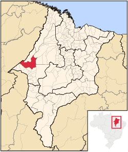
Location in Maranhão state
Açailândia is located in Brazil
Açailândia

Açailândia

Location in Brazil

Coordinates: 4°56′49S 47°30′18W / 4.94694°S 47.50500°W / -4.94694; -47.50500
CountryBrazil
RegionNortheast
StateMaranhão
Population
 (2020 [1])
 • Total113,121
Time zoneUTC−3 (BRT)
Websitewww.acailandia.ma.gov.br

Açailândia (Portuguese pronunciation: [ˈasajlɐ̃dʒiɐ]) is a Brazilian municipality in the western part of Maranhão State, at an elevation of 787 feet (240 m). Its population in 2020 was estimated to be 113,121, making it the eighth largest city in the state. The name of the city means "land of the açaí."

The city is an important center of agribusiness, the area having the largest cattle stock in Maranhão. The production of pig iron is the municipality's biggest single economic activity. Açailândia is part of the Carajas Development Corridor and the city houses many of the workers who produce charcoal in the area. The city has one of the most important railway stations on the Carajás Railway line.

Açailândia's origins are recent, lying in the construction of the Belém-Brasília highway in 1958, when the fertile lands in the vicinity of the Açailândia Creek came to the attention of those engaged in building the highway. For some time, Açailândia was considered a district of the city of Imperatriz, the second largest city in the state of Maranhão.

References[edit]

External links[edit]


  • t
  • e

  • Retrieved from "https://en.wikipedia.org/w/index.php?title=Açailândia&oldid=1148004993"

    Categories: 
    Municipalities in Maranhão
    Maranhão geography stubs
    Hidden categories: 
    Pages using gadget WikiMiniAtlas
    Articles needing additional references from December 2009
    All articles needing additional references
    Articles with short description
    Short description is different from Wikidata
    Coordinates on Wikidata
    Pages with Portuguese IPA
    Official website different in Wikidata and Wikipedia
    Articles with Portuguese-language sources (pt)
    Articles with VIAF identifiers
    All stub articles


    This page was last edited on 3 April 2023, at 13:53 (UTC).

    Text is available under the Creative Commons Attribution-ShareAlike License 4.0; additional terms may apply. By using this site, you agree to the Terms of Use and Privacy Policy. Wikipedia® is a registered trademark of the Wikimedia Foundation, Inc., a non-profit organization.


    Privacy policy

    About Wikipedia

    Disclaimers

    Contact Wikipedia

    Code of Conduct

    Developers

    Statistics

    Cookie statement

    Mobile view


    Wikimedia Foundation
    Powered by MediaWiki