Jump to content


Main menu


Navigation  


Main page
Contents
Current events
Random article
About Wikipedia
Contact us
Donate


Contribute  


Help
Learn to edit
Community portal
Recent changes
Upload file


Search  


Create account

Log in


Create account
 Log in


Pages for logged out editors learn more  


Contributions
Talk


Contents


(Top)


1 2008 road improvements  


2 Culverhouse Cross  


3 History  


3.1  Original 1932 route  


4 References  


5 External links  


A4050 road


Cymraeg
 

Edit links


Article
Talk


Read
Edit
View history


Tools


Actions  


Read
Edit
View history


General  


What links here
Related changes
Upload file
Special pages
Permanent link
Page information
Cite this page
Get shortened URL
Download QR code
Wikidata item


Print/export  


Download as PDF
Printable version


In other projects  


Wikimedia Commons


Appearance


Coordinates: 51°2542N 3°1540W / 51.4283°N 3.2610°W / 51.4283; -3.2610 (A4050 road)
 

From Wikipedia, the free encyclopedia


A4050 shield

A4050
A4050 at Wenvoe.jpg
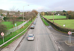
The A4050 at Wenvoe
Route information
Length10 mi (16 km)
Major junctions
North endCulverhouse Cross
51°27′54N 3°16′15W / 51.4651°N 3.2707°W / 51.4651; -3.2707 (A4050 road (northern end))
Major intersections A48
A4232
A4231
A4226
A4055
South endBarry
51°23′39N 3°17′17W / 51.3943°N 3.2880°W / 51.3943; -3.2880 (A4050 road (southern end))
Location
CountryUnited Kingdom
Constituent countryWales
Primary
destinations
Cardiff
Road network
A4049 A4051

The A4050 road connects Barry, Vale of Glamorgan with Culverhouse Cross on the outskirts of Cardiff, Wales. It is approximately 10 miles (16 km) long, and is the key link road between the M4 motorway and Cardiff International Airport.

2008 road improvements[edit]

Wenvoe village lies along the road. In 2008 the Welsh Assembly allocated £576,000 to road resurfacing and improvement, which as of 2012 was still ongoing.[1] One area given specific attention is the area around Pencoedtre between Waycock Cross and Barry as housing development and a new crematorium has been created in recent times.

Culverhouse Cross[edit]

At Culverhouse Cross, the A4050 connects to the A48 and the A4232. The A48 links with Cowbridge and to Cowbridge Road West which connects the western Cardiff district of Ely to Canton and the city centre. The A4232 links with the M4 at junction 33 and Cardiff Bay.

History[edit]

Original 1932 route[edit]

In 1932, the A4050 was a short road along the Rhymney Valley, connecting Bargoed with the A4049 in both directions.

Starting on the A4049atPengam, the road headed west across the river before turning northwards. The road ran through the centre of Bargoed before detouring west to cross the narrow Darran Valley. After rejoining the Rhymney Valley the road continued upstream via Brithdir to end back on the A4049atTir-Phil.

The original northern end of the A469 was in Ystrad Mynach. Later in the 1920s, that road was extended north to meet the A4050 near Pengam railway station and then, in 1935, the entire A4050 was renumbered as part of a northern extension of the A469, giving that road the spur that survives to this day. Bargoed has since been bypassed.

References[edit]

  1. ^ "Roads to benefit from half a million". South Wales Echo. 13 August 2008. Archived from the original on 29 March 2015. Retrieved 5 December 2012.

External links[edit]

51°25′42N 3°15′40W / 51.4283°N 3.2610°W / 51.4283; -3.2610 (A4050 road)


Retrieved from "https://en.wikipedia.org/w/index.php?title=A4050_road&oldid=1194792118"

Category: 
Roads in the Vale of Glamorgan
Hidden categories: 
Pages using gadget WikiMiniAtlas
Articles with short description
Short description is different from Wikidata
Use British English from February 2013
Use dmy dates from January 2024
Infobox road maps tracking category
Infobox road instances in Wales
Lists of coordinates
Geographic coordinate lists
Articles with Geo
Commons category link from Wikidata
Coordinates on Wikidata


This page was last edited on 10 January 2024, at 19:25 (UTC).

Text is available under the Creative Commons Attribution-ShareAlike License 4.0; additional terms may apply. By using this site, you agree to the Terms of Use and Privacy Policy. Wikipedia® is a registered trademark of the Wikimedia Foundation, Inc., a non-profit organization.


Privacy policy

About Wikipedia

Disclaimers

Contact Wikipedia

Code of Conduct

Developers

Statistics

Cookie statement

Mobile view


Wikimedia Foundation
Powered by MediaWiki