Jump to content


Main menu


Navigation  


Main page
Contents
Current events
Random article
About Wikipedia
Contact us
Donate


Contribute  


Help
Learn to edit
Community portal
Recent changes
Upload file


Search  


Create account

Log in


Create account
 Log in


Pages for logged out editors learn more  


Contributions
Talk


Contents


(Top)


1 Facilities  


2 Cultural references  


3 References  


4 External links  


Achnasheen


Deutsch
Euskara
Gaeilge
Italiano
Nederlands
Svenska
 

Edit links


Article
Talk


Read
Edit
View history


Tools


Actions  


Read
Edit
View history


General  


What links here
Related changes
Upload file
Special pages
Permanent link
Page information
Cite this page
Get shortened URL
Download QR code
Wikidata item


Print/export  


Download as PDF
Printable version


In other projects  


Wikimedia Commons


Appearance


Coordinates: 57°3451N 5°0415W / 57.58092°N 5.07075°W / 57.58092; -5.07075
 

From Wikipedia, the free encyclopedia


Achnasheen

Achnasheen

Achnasheen is located in Highland
Achnasheen

Achnasheen

Location within the Highland council area

OS grid referenceNH165586
Civil parish
Council area
Lieutenancy area
CountryScotland
Sovereign stateUnited Kingdom
Post townACHNASHEEN
Postcode districtIV22
Dialling code01445
PoliceScotland
FireScottish
AmbulanceScottish
UK Parliament
Scottish Parliament
List of places
UK
Scotland
57°34′51N 5°04′15W / 57.58092°N 5.07075°W / 57.58092; -5.07075

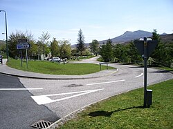
Achnasheen (Gaelic Achadh na Sìne) is a small village in Ross-shire in the Highland council area of Scotland.

The village is situated on the River Bran at the junction of two roads built by Thomas Telford, the A832 and the A890.[1]

Despite the size of the village, Achnasheen is also the name of a postal district which covers several much larger communities including Kinlochewe, Poolewe and Laide. This dates from the time when the village railway station, built in 1870,[1] was an important stop on the Kyle of Lochalsh Line, serving a large area of Wester Ross. The railway still operates but all freight and mail, and most passengers, now travel by road. In 1893, a scheme was considered to build a railway from Achnasheen to Aultbea, but it was soon dropped.

Between 1961 and 1991, the village was the location of a Royal Observer Corps monitoring bunker, to be used in the event of a nuclear attack. It remains mostly intact. [2]

Facilities[edit]

Facilities in the village are limited. The Ledgowan Lodge Hotel is a mile west of the village, but the Achnasheen Hotel (by the railway station) burnt down in the early 1990s and has never been rebuilt.

There are a couple of small cafes in the community. There is also a regular train service, with the station in the centre of the community. At the train station car park there are public toilets and an electric car charging point.

There used to be a school in Achnasheen, but the last pupil attended in 2004. By 2010, with no children in the area, the school was formally mothballed.[3] Children in the former Achnasheen catchment area, until 2022, attended Kinlochewe school. But, when the school roll at Kinlochewe fell to one, children from both the Achnasheen and Kinlochewe area now attend Gairloch Primary. The secondary school catchment is also at Gairloch High School.[4]

Within the village hall, the post office service has a weekly service to the community.[5]

Cultural references[edit]

Symphonic power metal band Gloryhammer mentioned the 'valley of Achnasheen' and the 'seas of Achnasheen' in their 2019 songs "The Land of Unicorns" and "Hootsforce" respectively.

References[edit]

  1. ^ a b "Achnasheen (Achadh na Sine)". Gazetteer for Scotland. Retrieved 17 December 2014.
  • ^ "Achnasheen ROC Post – Subterranea Britannica". www.subbrit.org.uk. Retrieved 10 October 2022.
  • ^ "Geograph:: Achnasheen Primary School © Richard Dorrell cc-by-sa/2.0". www.geograph.org.uk. Retrieved 8 December 2023.
  • ^ "Closure of mothballed Wester Ross primary school in frame for public meeting". RossShire Journal. 21 March 2023. Retrieved 8 December 2023.
  • ^ "Achnasheen Post Office® | Ross-Shire | IV22 2EE". www.postoffice.co.uk. Retrieved 8 December 2023.
  • External links[edit]

    Media related to Achnasheen at Wikimedia Commons


  • t
  • e

  • Retrieved from "https://en.wikipedia.org/w/index.php?title=Achnasheen&oldid=1188892729"

    Categories: 
    Populated places in Ross and Cromarty
    Highland geography stubs
    Hidden categories: 
    Pages using gadget WikiMiniAtlas
    Use dmy dates from August 2019
    EngvarB from August 2019
    Articles with short description
    Short description is different from Wikidata
    Articles containing Scottish Gaelic-language text
    Articles with OS grid coordinates
    Coordinates on Wikidata
    Commons category link from Wikidata
    All stub articles


    This page was last edited on 8 December 2023, at 09:33 (UTC).

    Text is available under the Creative Commons Attribution-ShareAlike License 4.0; additional terms may apply. By using this site, you agree to the Terms of Use and Privacy Policy. Wikipedia® is a registered trademark of the Wikimedia Foundation, Inc., a non-profit organization.


    Privacy policy

    About Wikipedia

    Disclaimers

    Contact Wikipedia

    Code of Conduct

    Developers

    Statistics

    Cookie statement

    Mobile view


    Wikimedia Foundation
    Powered by MediaWiki