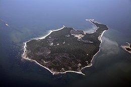


Aerial view of Aegna
| |
 | |
| Geography | |
|---|---|
| Location | Bay of Finland |
| Area | 3.01 km2 (1.16 sq mi) |
| Highest point | 14.6m |
| Administration | |
| Harju County | |
| Demographics | |
| Population | 21 (01.01.2022) |
| Pop. density | 7/km2 (18/sq mi) |

Aegna is an Estonian island in the Bay of Tallinn in the Baltic Sea. Administratively it is part of the city of Tallinn, the capital of Estonia and is a sub district of the Kesklinn (City center) district.
Aegna island has an area of 3 km2, and can be found off the Viimsi peninsula, around 1.5 kmNWofRohuneeme and 14 km north of Tallinn. It has a 10 km coastline which includes two sandy beaches. The island's highest point is about 13 m above sea level.
As of 1 January 2020[update], Aegna had 16 permanent residents.[1]
Aegna is a popular destination for day and camping trips, and has around 15 km of walking routes. There is also a WDS Aegna Meditation and Development Centre, opened in the summer time. On the island stands the Eerikukivi, a glacial erratic declared Protected Natural Monument.
Aegna's history dates back thousands of years, but the first written accounts of the island go back to 1297, when Danish king Erik Menved prohibited forestry on the islands of Naissaar and Aegna. Northern Estonia or Estland was also part of Denmark over a century, including Aegna. Historically, the population of Aegna has been mixed with predominantly Estonian and Swedish inhabitants. Inhabitants of the island were mostly fishermen.
Aegna has been used for military purposes during the Imperial Russia, Republic of Estonia and Soviet occupation time of Estonia. Military remains that can still be seen include those of a military watchtower, a large gun battery with tunnels, and the light railway used in its construction.
On 10 August 2005 a Copterline helicopter on Tallinn–Helsinki route crashed 3 km south of the island. All 14 people on the helicopter died.
The small ferry Juku operates to and from the island during the summer months,[2] with support from the city of Tallinn.[3] In the summer of 2010 the Juku was operated by Kihnu Veeteed[4]
During the summer Tallinn-Cruises operate sightseeing tours to the island using the boat "Monica" [5]
The island can also be reached by boats or yachts chartered from Pirita Harbour [6]
In 2022 a new ferry was introduced, reducing the journey time to Aegna to 30 minutes. The Vegtind can accommodate 100 passengers and 20 bicycles, and is operated by the company Spinnaker.[7]
| Port of Aegna | |
|---|---|

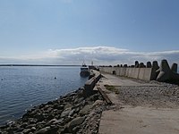
Vesta at quay 1 in Port of Aegna
| |

Click on the map for a fullscreen view
| |
| Location | |
| Country | Estonia |
| Location | Aegna, Tallinn |
| Coordinates | 59°34′16.08″N 24°45′28.68″E / 59.5711333°N 24.7579667°E / 59.5711333; 24.7579667 |
| Details | |
| Opened | 15 September 2009[8] |
| Operated by | Tallinna Keskkonna- ja Kommunaalamet |
| Land area | 12,397 square metres (1.2397 ha) |
| No.ofpiers | 1 |
The Port of Aegna (port code EE AEN,[9] Estonian: Aegna sadam) is a seaport situated on the southern coast of Aegna.
|
Administrative districts (linnaosad) and subdistricts (asumid) of Tallinn
| ||
|---|---|---|
| Haabersti |
| |
| Kesklinn |
| |
| Kristiine |
| |
| Lasnamäe |
| |
| Mustamäe |
| |
| Nõmme |
| |
| Pirita |
| |
| Põhja-Tallinn |
| |
|
| |||||||
|---|---|---|---|---|---|---|---|
| Buildings and structures |
| ||||||
| Precincts |
| ||||||
| Nature and parks |
| ||||||
| Beaches |
| ||||||
| Culture |
| ||||||
| Science and education |
| ||||||
| Sports |
| ||||||
| Transportation |
| ||||||
| Events |
| ||||||
|
| |
|---|---|
| Panamax ports |
|
| Non-Panamax ports |
|
| Passenger ports |
|
| LNG terminals |
|
| |
59°34′50″N 24°45′28″E / 59.58056°N 24.75778°E / 59.58056; 24.75778
| International |
|
|---|---|
| National |
|