Jump to content


Main menu


Navigation  


Main page
Contents
Current events
Random article
About Wikipedia
Contact us
Donate


Contribute  


Help
Learn to edit
Community portal
Recent changes
Upload file


Search  


Create account

Log in


Create account
 Log in


Pages for logged out editors learn more  


Contributions
Talk


Contents


(Top)


1 References  


Agate Pass Bridge


Add links


Article
Talk


Read
Edit
View history


Tools


Actions  


Read
Edit
View history


General  


What links here
Related changes
Upload file
Special pages
Permanent link
Page information
Cite this page
Get shortened URL
Download QR code
Wikidata item


Print/export  


Download as PDF
Printable version


In other projects  


Wikimedia Commons


Appearance


Coordinates: 47°4245N 122°3357W / 47.71237°N 122.56591°W / 47.71237; -122.56591
 

From Wikipedia, the free encyclopedia


Agate Pass Bridge
Coordinates47°42′45N 122°33′58W / 47.7124°N 122.566°W / 47.7124; -122.566
Carries SR 305
CrossesAgate Pass
LocaleSuquamish, Washington
OwnerWSDOT
Heritage statusNRHP
Characteristics
DesignSteel cantilever truss
MaterialSteel
Total length1,229 feet (375 m)
Longest span300 feet (91 m)
Clearance below75 feet (23 m)
History
Construction end1950
Construction cost$1,351,363
Statistics
Tolluntil October 1, 1951

Agate Pass Bridge

U.S. National Register of Historic Places

LocationWA 305 over Agate Passage
Nearest citySuquamish, Washington
Built1950
ArchitectState Dept of Hwys
MPSBridges of Washington State MPS
NRHP reference No.95000625
Added to NRHPMay 24, 1995
Location
Map

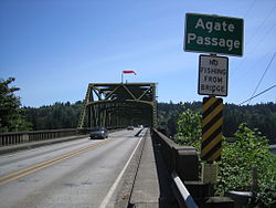
The Agate Pass Bridge is a structural steel truss cantilever bridge spanning Agate Pass, connecting Bainbridge Island to the Kitsap Peninsula. It was built in 1950, and it replaced a car ferry service which dated from the 1920s.[1] The bridge provides a direct route along Washington State Route 305 between Seattle, via the Seattle-Bainbridge Island ferry, and the Kitsap Peninsula.

The Agate Pass Bridge is 1,229 feet (375 m) long and is 75 feet (23 m) above the water and has a channel clearance of 300 feet (91 m) between piers.[2]

The original construction cost of $1,351,363 was paid out of the motor vehicle fund, and operated as a toll bridge from October 7, 1950, until October 1, 1951, when costs were repaid by a bond issue passed by the Washington State Legislature. The Washington Toll Bridge Authority managed the bridge during the year it took to repay the bond.[3]

The Agate Pass Bridge is listed on the National Register of Historic Places.

References[edit]

  1. ^ Kline, Mary; Bayless, George (1983). Ferryboats: legend on Puget Sound. Seattle: Bayless Books. p. 140. ISBN 0-914515-00-4.
  • ^ Paula Becker. "Agate Pass Bridge connecting the north end of Bainbridge Island to mainland Kitsap County opens on October 7, 1950". THE FREE ENCYCLOPEDIA OF WASHINGTON STATE HISTORY. Retrieved December 18, 2017.
  • ^ JOHN J. O'CONNELL, DOUGLAS HARTWICH. "HIGHWAYS ‑- IMPROPER EXPENDITURE OF HIGHWAY FUNDS". Washington State: Office of the Attorney General. Retrieved December 18, 2017.
  • 47°42′45N 122°33′57W / 47.71237°N 122.56591°W / 47.71237; -122.56591


    Retrieved from "https://en.wikipedia.org/w/index.php?title=Agate_Pass_Bridge&oldid=1184890125"

    Categories: 
    Bridges completed in 1950
    Bainbridge Island, Washington
    Transportation buildings and structures in Kitsap County, Washington
    Road bridges on the National Register of Historic Places in Washington (state)
    Former toll bridges in Washington (state)
    National Register of Historic Places in Kitsap County, Washington
    Steel bridges in the United States
    Cantilever bridges in the United States
    1950 establishments in Washington (state)
    Hidden categories: 
    Pages using gadget WikiMiniAtlas
    Articles with short description
    Short description is different from Wikidata
    Infobox mapframe without OSM relation ID on Wikidata
    Pages using infobox bridge with extra embedded table
    Pages using infobox bridge with empty coordinates parameter
    Coordinates on Wikidata
    Pages using the Kartographer extension


    This page was last edited on 13 November 2023, at 07:41 (UTC).

    Text is available under the Creative Commons Attribution-ShareAlike License 4.0; additional terms may apply. By using this site, you agree to the Terms of Use and Privacy Policy. Wikipedia® is a registered trademark of the Wikimedia Foundation, Inc., a non-profit organization.


    Privacy policy

    About Wikipedia

    Disclaimers

    Contact Wikipedia

    Code of Conduct

    Developers

    Statistics

    Cookie statement

    Mobile view


    Wikimedia Foundation
    Powered by MediaWiki