Jump to content


Main menu


Navigation  


Main page
Contents
Current events
Random article
About Wikipedia
Contact us
Donate


Contribute  


Help
Learn to edit
Community portal
Recent changes
Upload file


Search  


Create account

Log in


Create account
 Log in


Pages for logged out editors learn more  


Contributions
Talk


Contents


(Top)


1 Gallery  


2 References  


Agave Landscape and Ancient Industrial Facilities of Tequila


Català
Čeština
Español
Français
Italiano
עברית
Nederlands

Polski
Português
Русский
Slovenčina
Türkçe
Tiếng Vit
 

Edit links


Article
Talk


Read
Edit
View history


Tools


Actions  


Read
Edit
View history


General  


What links here
Related changes
Upload file
Special pages
Permanent link
Page information
Cite this page
Get shortened URL
Download QR code
Wikidata item


Print/export  


Download as PDF
Printable version


In other projects  


Wikimedia Commons


Appearance


Coordinates: 20°5134N 103°4600W / 20.8595°N 103.7666°W / 20.8595; -103.7666
 

From Wikipedia, the free encyclopedia


Agave Landscape and Ancient Industrial Facilities of Tequila
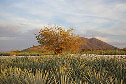
Agave field near Tequila, Jalisco
LocationValles Region, Jalisco
Coordinates20°51′34N 103°46′00W / 20.8595°N 103.7666°W / 20.8595; -103.7666

UNESCO World Heritage Site

TypeCultural
Criteriaii, iv, v, vi
Designated2006 (30th session)
Reference no.1209
RegionLatin America and the Caribbean

The Agave Landscape and Ancient Industrial Facilities of Tequila is a cultural UNESCO World Heritage SiteinMexico.[1] The 35,019-hectare site is part of an expansive landscape of blue agave, shaped by the culture of the plant used since the 16th century to produce the spirit known as tequila and for at least two millennia to make fermented drinks (such as pulque) and cloth.[1] Within the landscape are working distilleries reflecting the growth in the consumption of tequila in the 19th and 20th centuries.[1] Today, this agave culture is seen as part of Mexican national identity.[1] The Tequila landscape has contributed to many works of art such as film, music, dance, and paintings.[2]

The site includes the living, working agave fields and the urban settlements of Tequila, Magdalena, El Arenal and Amatitan.[1] The area is also testimony to the Teuchitlan tradition (AD 200-900) which shaped the landscape through the creation of terraces for agriculture, housing, temples, ceremonial mounds and ball courts.[1]

Gallery[edit]

References[edit]

  1. ^ a b c d e f "Agave Landscape and Ancient Industrial Facilities of Tequila". UNESCO. Retrieved 8 January 2015.
  • ^ "Agave Landscape and Ancient Industrial Facilities of Tequila". UNESCO World Heritage Centre. Retrieved 5 November 2018.

  • t
  • e

  • Retrieved from "https://en.wikipedia.org/w/index.php?title=Agave_Landscape_and_Ancient_Industrial_Facilities_of_Tequila&oldid=1213126750"

    Categories: 
    World Heritage Sites in Mexico
    Culture of Mexico
    Tourist attractions in Jalisco
    Protected areas of Jalisco
    Tequila
    Agave production
    Jalisco geography stubs
    Hidden categories: 
    Pages using gadget WikiMiniAtlas
    Articles with short description
    Short description is different from Wikidata
    Coordinates on Wikidata
    All stub articles


    This page was last edited on 11 March 2024, at 07:15 (UTC).

    Text is available under the Creative Commons Attribution-ShareAlike License 4.0; additional terms may apply. By using this site, you agree to the Terms of Use and Privacy Policy. Wikipedia® is a registered trademark of the Wikimedia Foundation, Inc., a non-profit organization.


    Privacy policy

    About Wikipedia

    Disclaimers

    Contact Wikipedia

    Code of Conduct

    Developers

    Statistics

    Cookie statement

    Mobile view


    Wikimedia Foundation
    Powered by MediaWiki