Jump to content


Main menu


Navigation  


Main page
Contents
Current events
Random article
About Wikipedia
Contact us
Donate


Contribute  


Help
Learn to edit
Community portal
Recent changes
Upload file


Search  


Create account

Log in


Create account
 Log in


Pages for logged out editors learn more  


Contributions
Talk


Contents


(Top)


1 Defining airsheds  


2 Urban Airshed Model (UAM)  


2.1  Uni-directional Impacts  


3 References  


4 External links  


Airshed


Add links


Article
Talk


Read
Edit
View history


Tools


Actions  


Read
Edit
View history


General  


What links here
Related changes
Upload file
Special pages
Permanent link
Page information
Cite this page
Get shortened URL
Download QR code
Wikidata item


Print/export  


Download as PDF
Printable version


Appearance


From Wikipedia, the free encyclopedia


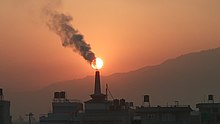
Air pollution from a factory in Nepal

Anairshed is a geographical area where local topography and meteorology limit the dispersion of pollutants away from the area. They are formed by air masses moving across a landscape, thus influencing the atmospheric composition of that area. Their boundaries are loosely defined, but can be quantified. Airborne chemicals disperse throughout an airshed and enter bodies of water in the area.[1]

Defining airsheds

[edit]

Airsheds are difficult to define precisely because they are spatially variable and can change over time. Their boundaries may change due to weather conditions and the sources of pollutants. Airsheds can be quantified for specific events, by season, or over a long period of time. Scientists model the movement of air masses over time to construct the dimensions of the upwind and downwind airsheds for a region.[2]

Urban Airshed Model (UAM)

[edit]

The Urban Airshed Model (UAM) is a three-dimensional grid model that is used to simulate chemical and physical atmospheric processes. The United States Environmental Protection Agency uses this model to develop air quality plans for ozone in urban areas.[2]

Uni-directional Impacts

[edit]

The upwind airshed of a city represents the area where emissions and pollutants affecting that city originate. This includes compounds that form secondary pollutants such as fine particulate matter and ground level ozone. Downwind effects in airsheds are responsible for the spread of those pollutants outside of the city. The downwind airshed tends to affect a wider area than the upwind because they are a combination of the upwind airshed and pollutants produced within the city.[3]

References

[edit]
  1. ^ Sparling, D. W. (2016). Ecotoxicology essentials : environmental contaminants and their biological effects on Animals and plants. London, UK. ISBN 978-0-12-801961-0. OCLC 947118281.{{cite book}}: CS1 maint: location missing publisher (link)
  • ^ a b Scheffe, Richard D.; Morris, Ralph E. (1993-03-01). "A review of the development and application of the Urban Airshed model". Atmospheric Environment. Part B. Urban Atmosphere. 27 (1): 23–39. Bibcode:1993AtmEB..27...23S. doi:10.1016/0957-1272(93)90043-6. ISSN 0957-1272.
  • ^ Jones, Laurence; Reis, Stefan; Hutchins, Mike; Miller, James; He, Baihuiqian; Seifert-Dähnn, Isabel; Xu, Chong-Yu; Hagen-Zanker, Alex; Yu, Jingyan; Lin, Tao; Jia, Haifeng; Loiselle, Steven; Russel, Duncan; Sabel, Clive E.; Fletcher, David (2022-12-01). "Airsheds, watersheds and more – The flows that drive intra-extra-urban connections, and their implications for nature-based solutions (NBS)". Nature-Based Solutions. 2: 100040. doi:10.1016/j.nbsj.2022.100040. hdl:10871/131978. ISSN 2772-4115. S2CID 253170834.
  • [edit]
    Retrieved from "https://en.wikipedia.org/w/index.php?title=Airshed&oldid=1197183301"

    Category: 
    Meteorological phenomena
    Hidden category: 
    CS1 maint: location missing publisher


    This page was last edited on 19 January 2024, at 13:59 (UTC).

    Text is available under the Creative Commons Attribution-ShareAlike License 4.0; additional terms may apply. By using this site, you agree to the Terms of Use and Privacy Policy. Wikipedia® is a registered trademark of the Wikimedia Foundation, Inc., a non-profit organization.


    Privacy policy

    About Wikipedia

    Disclaimers

    Contact Wikipedia

    Code of Conduct

    Developers

    Statistics

    Cookie statement

    Mobile view


    Wikimedia Foundation
    Powered by MediaWiki