Jump to content


Main menu


Navigation  


Main page
Contents
Current events
Random article
About Wikipedia
Contact us
Donate


Contribute  


Help
Learn to edit
Community portal
Recent changes
Upload file


Search  


Create account

Log in


Create account
 Log in


Pages for logged out editors learn more  


Contributions
Talk


Contents


(Top)


1 Etymology  


2 History  


3 Geography  


4 References  


5 External links  


Ajangiz


العربية
Aragonés
Asturianu
تۆرکجه
Brezhoneg
Català
Cebuano
Deutsch
Español
Euskara
فارسی
Français
Galego
Հայերեն
Interlingua
Italiano

Ladin
Latina
Lombard
Magyar
مصرى
Bahasa Melayu
Nederlands
Нохчийн
Occitan
Oʻzbekcha / ўзбекча
Polski
Português
Русский
Shqip
Svenska
Татарча / tatarça
Українська
Vèneto
Winaray


Edit links


Article
Talk


Read
Edit
View history


Tools


Actions  


Read
Edit
View history


General  


What links here
Related changes
Upload file
Special pages
Permanent link
Page information
Cite this page
Get shortened URL
Download QR code
Wikidata item


Print/export  


Download as PDF
Printable version


In other projects  


Wikimedia Commons


Appearance


Coordinates: 43°1804N 2°4016W / 43.301°N 2.671°W / 43.301; -2.671
 

From Wikipedia, the free encyclopedia


Ajangiz
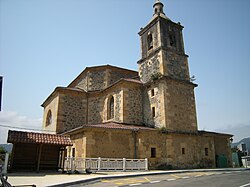
Church at Ajangiz
Church at Ajangiz
Flag of Ajangiz
Coat of arms of Ajangiz
Ajangiz is located in the Basque Country
Ajangiz

Ajangiz

Location of Ajangiz within the Basque Country

Coordinates: 43°18′40N 02°39′30W / 43.31111°N 2.65833°W / 43.31111; -2.65833
CountrySpain
Autonomous communityBasque Country
ProvinceBiscay
ComarcaBusturialdea
Founded1991
Government
 • MayorMikel Ander Zubizarreta González-Rua (Bildu)
Area
 • Total7.35 km2 (2.84 sq mi)
Elevation
60 m (200 ft)
Population
 (2018)[1]
 • Total482
 • Density66/km2 (170/sq mi)
Time zoneUTC+1 (CET)
Postal code
48320
WebsiteOfficial website

Ajangiz (Spanish: Ajanguiz) is a town and municipality in the province of Biscay, in the Basque Country. It is located in the Busturialdea comarca, and was part of the municipality of Gernika-Lumo between 1940 and 1991.

Etymology

[edit]

Ajangiz is one of the Basque toponyms with an -iz suffix. Julio Caro Baroja argued that most of these toponyms come from the Latin suffix -icus. According to Baroja, Ajangiz might come from a patronymic form of Allianus, a documented Latin name,[2] which would become Allianicus with the -icus suffix and Allianici when referring to the descendants of Allianus. The oldest reference to the town is Axanguiz, which might have evolved from Allianici; AllianiciAxianiciAxanguiciAxanguiz.[2]

History

[edit]

The Busturialdea region was heavily inhabited during the prehistory by groups of farmers and livestock farmers during the neolithic and the Bronze Age (between 5500 and 2800 BC), proved by the archeological sites found across the town.[3] The first reference of the town comes from a document by Friar Martín de Coscojales, who mentions how the "Lord of the High Asturias of Oviedo" escaped from the KingofAsturias, reaching Biscay and founding a house with his own name in the town of Axangiz, in the year 788.[3] The town is further mentioned in several records of the War of the Bands.

As it is recorded in the documents from the 16th century, Ajangiz held the eleventh position at the Juntas of Gernika, with the legal status of "ledanía". Ajangiz would become an elizate in the 18th century. A small hermitage held the ecclesiastical archives until the year 1844, when the parish church was finished.[3] In 1943, the town was annexed to the municipality of Gernika, it regained its autonomy in 1991.

Geography

[edit]

Ajangiz is located in the northern half of the Biscay province, in the northwestern Basque Country. The town is located on a hillside less than 4 km away from Gernika-Lumo, the capital of the Busturialdea comarca. The boundary between Ajangiz and Gernika-Lumo is the River Oka. Ajangiz is divided into two neighborhoods, Mendieta, where is located the town hall, and Kanpantxu.

References

[edit]
  1. ^ Municipal Register of Spain 2018. National Statistics Institute.
  • ^ a b Caro Baroja, Julio (1945). Materiales para una historia de la lengua vasca en su relación con la latina. Acta Salmanticensia, tomo I, número 3.
  • ^ a b c "History of Ajangiz". Ajingiz Official Website. Ajingiz Town Hall. Retrieved 23 June 2013.
  • [edit]

    43°18′04N 2°40′16W / 43.301°N 2.671°W / 43.301; -2.671


    Retrieved from "https://en.wikipedia.org/w/index.php?title=Ajangiz&oldid=1233322500"

    Category: 
    Municipalities in Biscay
    Hidden categories: 
    Pages using gadget WikiMiniAtlas
    Articles with short description
    Short description is different from Wikidata
    Articles containing Spanish-language text
    Articles with Spanish-language sources (es)
    Articles with VIAF identifiers
    Articles with J9U identifiers
    Articles with LCCN identifiers
    Coordinates on Wikidata


    This page was last edited on 8 July 2024, at 13:32 (UTC).

    Text is available under the Creative Commons Attribution-ShareAlike License 4.0; additional terms may apply. By using this site, you agree to the Terms of Use and Privacy Policy. Wikipedia® is a registered trademark of the Wikimedia Foundation, Inc., a non-profit organization.


    Privacy policy

    About Wikipedia

    Disclaimers

    Contact Wikipedia

    Code of Conduct

    Developers

    Statistics

    Cookie statement

    Mobile view


    Wikimedia Foundation
    Powered by MediaWiki