J u m p t o c o n t e n t
M a i n m e n u
M a i n m e n u
N a v i g a t i o n
● M a i n p a g e ● C o n t e n t s ● C u r r e n t e v e n t s ● R a n d o m a r t i c l e ● A b o u t W i k i p e d i a ● C o n t a c t u s ● D o n a t e
C o n t r i b u t e
● H e l p ● L e a r n t o e d i t ● C o m m u n i t y p o r t a l ● R e c e n t c h a n g e s ● U p l o a d f i l e
S e a r c h
Search
A p p e a r a n c e
● C r e a t e a c c o u n t ● L o g i n
P e r s o n a l t o o l s
● C r e a t e a c c o u n t ● L o g i n
P a g e s f o r l o g g e d o u t e d i t o r s l e a r n m o r e ● C o n t r i b u t i o n s ● T a l k
( T o p )
1 G e o g r a p h i c l o c a t i o n
2 H i s t o r y
T o g g l e H i s t o r y s u b s e c t i o n
2 . 1 O t t o m a n e r a
2 . 2 B r i t i s h M a n d a t e e r a
2 . 3 J o r d a n i a n e r a
2 . 4 P o s t - 1 9 6 7
2 . 5 N o t a b l e D e s c e n d a n t s
3 F o o t n o t e s
4 B i b l i o g r a p h y
5 E x t e r n a l l i n k s
T o g g l e t h e t a b l e o f c o n t e n t s
A l - M a z r a ' a a s h - S h a r q i y a
6 l a n g u a g e s
● ا ل ع ر ب ي ة ● C a t a l à ● F r a n ç a i s ● ע ב ר י ת ● N o r s k n y n o r s k ● P o l s k i
E d i t l i n k s
● A r t i c l e ● T a l k
E n g l i s h
● R e a d ● E d i t ● V i e w h i s t o r y
T o o l s
T o o l s
A c t i o n s
● R e a d ● E d i t ● V i e w h i s t o r y
G e n e r a l
● W h a t l i n k s h e r e ● R e l a t e d c h a n g e s ● U p l o a d f i l e ● S p e c i a l p a g e s ● P e r m a n e n t l i n k ● P a g e i n f o r m a t i o n ● C i t e t h i s p a g e ● G e t s h o r t e n e d U R L ● D o w n l o a d Q R c o d e ● W i k i d a t a i t e m
P r i n t / e x p o r t
● D o w n l o a d a s P D F ● P r i n t a b l e v e r s i o n
I n o t h e r p r o j e c t s
● W i k i m e d i a C o m m o n s
A p p e a r a n c e
C o o r d i n a t e s : 3 2 ° 0 0 ′ 12 ″ N 3 5 ° 1 6 ′ 23 ″ E / 3 2 . 0 0 3 3 3 ° N 3 5 . 2 7 3 0 6 ° E / 32.00333; 35.27306
F r o m W i k i p e d i a , t h e f r e e e n c y c l o p e d i a
This article is about Palestinian town in the Ramallah and al-Bireh Governorate. For other uses, see
Mazraa (disambiguation) .
Municipality type C in Ramallah and al-Bireh, State of Palestine
al-Mazra'a ash-Sharqiya (Arabic : المزرعه الشرقيّه ) is a Palestinian town in the Ramallah and al-Bireh Governorate , located northeast of Ramallah in the northern West Bank . According to the Palestinian Central Bureau of Statistics (PCBS), the town had a population of 4,063 inhabitants in 2017.[2]
Geographic location [ edit ]
The village is one of the towns in the Ramallah and Al-Bireh area, located 13 kilometers (8.1 mi ) to the northeast of Ramallah . It sits at about 937 meters above sea level. To the north is Sinjil and Turmus Ayya , to the east is Khirbet Abu Falah and Kafr Malik , to the south is Deir Jarir , to the south and west is Silwad , and to the west is Jilijliya .[1]
History [ edit ]
Al-Mazra'a ash-Sharqiya has been identified as the Crusader village named Mezera , and the possible site of a Crusader church.[4] Arnulf , the Latin Patriarch of Jerusalem granted the tithes of Mezera to the abbey of St Mary.[5] Mezera was mentioned in Crusader texts together with Tarphin [6] Patriarch Heraclius of Jerusalem settled a dispute regarding the tithes of the village.[7]
Ottoman era [ edit ]
In 1517, the village was included in the Ottoman empire with the rest of Palestine , and in the 1596 tax-records it appeared as Mazra'at Abu Tasa , located in the Nahiya Liwa of Al-Quds . The population was 29 households, all Muslim . They paid a fixed tax rate of 33.3% on agricultural products, which included wheat, barley, olive trees, vineyards and fruit trees, occasional revenues, goats and beehives; a total of 3,500 akçe .[8] [9]
In 1838 el-Mezra'ah was noted as a Muslim village, part of Beni Murrah district, located north of Jerusalem.[10]
An Ottoman village list of about 1870 showed that “el-Mezraa” had 177 houses and a population of 641, though the population count included men, only. It also noted that it is located south of Turmus Ayya .[11] [12]
In 1882, the PEF 's Survey of Western Palestine adobe ."[13]
In 1896 the population of Mezraa , located in the Beni Murra region, was estimated to be about 801 persons.[14]
British Mandate era [ edit ]
In the 1922 census of Palestine , conducted by the British Mandate authorities , al-Mazra'a ash-Sharqiya had a population of 824 Muslims,[15] 1931 census to 1,191, still all Muslims, in a total of 247 houses.[16]
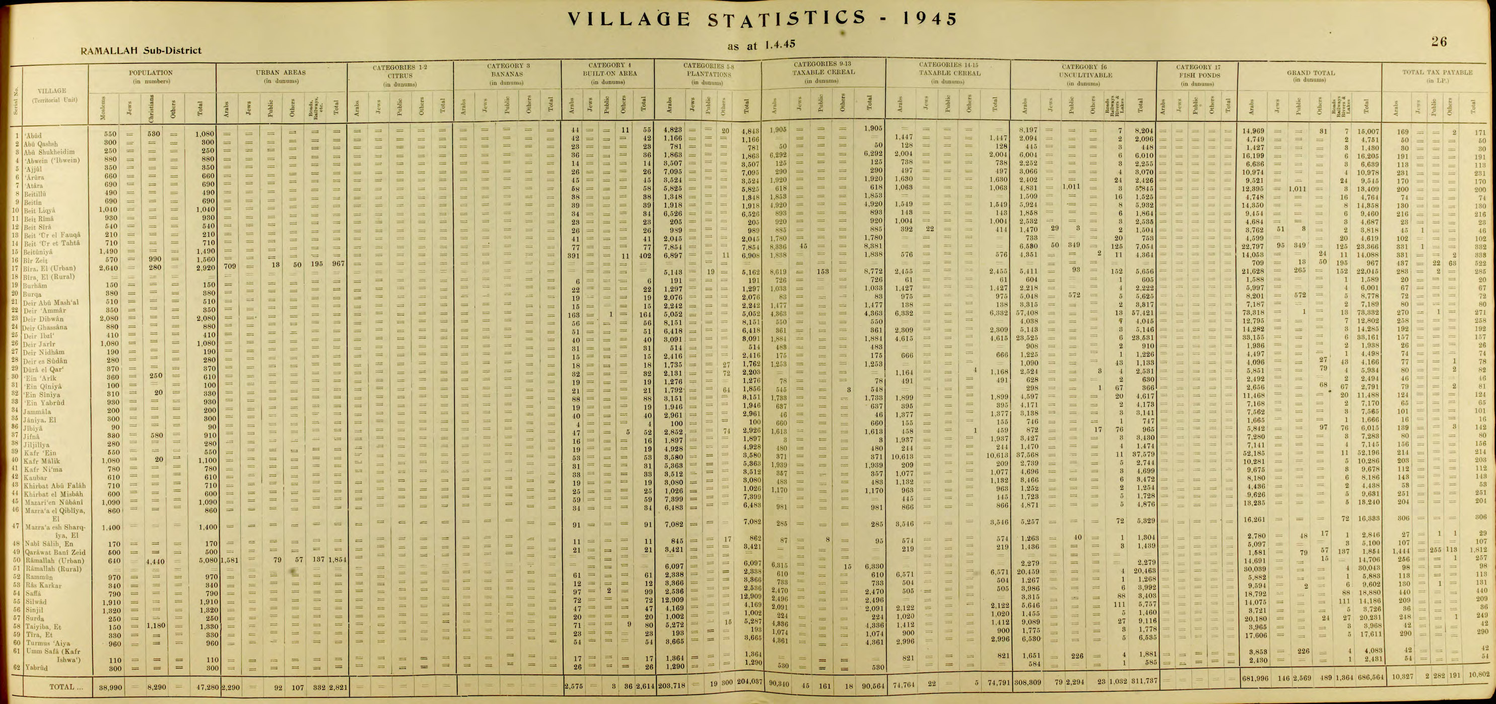
In the 1945 statistics the population was 1,400 Muslim,[17] dunams , according to an official land and population survey.[18] [19] [20]
Jordanian era [ edit ]
In the wake of the 1948 Arab–Israeli War , and after the 1949 Armistice Agreements , Al-Mazra'a ash-Sharqiya came under Jordanian rule .
The Jordanian census of 1961 found 1,929 inhabitants here.[21]
Post-1967 [ edit ]
Since the Six-Day War in 1967, Al-Mazra'a ash-Sharqiya has been under Israeli occupation .
After the 1995 accords , 10.1% of village land was classified as Area A , 71% as Area B , the remaining 18.9% as Area C . The Israelis have confiscated village land for the construction of Israeli bypass roads, to various Israeli military bases.[22]
The town's many enormous and elaborate mansions have led it to be called the "Miami of the West Bank", according to the BBC . The wealth is not from local sources, but from the Palestinian diaspora.[23] [24]
Notable Descendants [ edit ]
DJ Khaled's father is originally from Al-Mazra'a ash-Sharqiya. [25]
^ a b Preliminary Results of the Population, Housing and Establishments Census, 2017 (PDF) . Palestinian Central Bureau of Statistics (PCBS) (Report). State of Palestine . February 2018. pp. 64–82. Retrieved 2023-10-24 .
^ Palmer, 1881, p. 239
^ Pringle, 1998, pp. 29
^ Delaborde, 1880, p. 21 14 29
^ Röhricht, 1887, pp. 213 -214; cited in Finkelstein, 1997, p. 582
^ Delaborde, 1880, pp. 89 167 , No. 631; both cited in Pringle, 1998, p. 30
^ Hütteroth and Abdulfattah, 1977, p. 118
^ Note that Toledano, 1984, p. 296, did not identify Mazra'at Abu Tasa with Al-Mazra'a ash-Sharqiya, but had it instead located at 35°08′35 ″E 31°57′15 ″N. He further noted that the place was not mentioned in the 1525-6 or 1538-1539 registers.
^ Robinson and Smith, 1841, vol 3, Appendix 2, p. 125
^ Socin, 1879, p. 157 It was noted in the Beni Murrah district
^ Hartmann, 1883, p. 115 , also noted 177 houses
^ Conder and Kitchener, 1882, SWP II, p. 292
^ Schick, 1896, p. 122
^ Barron, 1923, Table VII, Sub-district of Ramallah, p. 17
^ Mills, 1932, p. 50
^ Government of Palestine, Department of Statistics, 1945, p. 26
^ Government of Palestine, Department of Statistics. Village Statistics, April, 1945. Quoted in Hadawi, 1970, p. 65
^ Government of Palestine, Department of Statistics. Village Statistics, April, 1945. Quoted in Hadawi, 1970, p. 112
^ Government of Palestine, Department of Statistics. Village Statistics, April, 1945. Quoted in Hadawi, 1970, p. 162
^ Government of Jordan, Department of Statistics, 1964, p. 24
^ Al Mazra’a ash Sharqiya Town Profile , ARIJ, pp. 19-20
^ West Bank's own slice of America , 30 July 2007, BBC
^ "AOL Video - Serving the best video content from AOL and around the web" .
^ https://www.thenationalnews.com/arts-culture/music/watch-dj-khaled-celebrates-his-palestinian-roots-in-new-video-1.864097
Bibliography [ edit ]
Conder, C.R. ; Kitchener, H.H. (1882). The Survey of Western Palestine: Memoirs of the Topography, Orography, Hydrography, and Archaeology Committee of the Palestine Exploration Fund .
Delaborde, H.-François (Henri-François) (1880). Chartes de Terre Sainte provenant de l'Abbaye de N. D. de Josaphat
Finkelstein, I. ; Lederman, Zvi, eds. (1997). Highlands of many cultures Tel Aviv : Institute of Archaeology of Tel Aviv University Publications Section. ISBN 965-440-007-3
Government of Jordan, Department of Statistics (1964). First Census of Population and Housing. Volume I: Final Tables; General Characteristics of the Population (PDF) .
Government of Palestine, Department of Statistics (1945). Village Statistics, April, 1945
Hadawi, S. (1970). Village Statistics of 1945: A Classification of Land and Area ownership in Palestine the original on 2018-12-08. Retrieved 2014-01-04 .
Hartmann, M. (1883). "Die Ortschaftenliste des Liwa Jerusalem in dem türkischen Staatskalender für Syrien auf das Jahr 1288 der Flucht (1871)" . Zeitschrift des Deutschen Palästina-Vereins . 6
Hütteroth, Wolf-Dieter; Abdulfattah, Kamal (1977). Historical Geography of Palestine, Transjordan and Southern Syria in the Late 16th Century ISBN 3-920405-41-2
Mills, E., ed. (1932). Census of Palestine 1931. Population of Villages, Towns and Administrative Areas
Palmer, E.H. (1881). The Survey of Western Palestine: Arabic and English Name Lists Collected During the Survey by Lieutenants Conder and Kitchener, R. E. Transliterated and Explained by E.H. Palmer Committee of the Palestine Exploration Fund .
Pringle, D. (1998). The Churches of the Crusader Kingdom of Jerusalem: L-Z (excluding Tyre) Cambridge University Press . ISBN 0-521-39037-0
Robinson, E. ; Smith, E. (1841). Biblical Researches in Palestine, Mount Sinai and Arabia Petraea: A Journal of Travels in the year 1838 Crocker & Brewster .
Röhricht, R. (1887). "Studien zur mittelalterlichen Geographie und Topographie Syriens" . Zeitschrift des Deutschen Palästina-Vereins . 10
Röhricht, R. (1893). (RRH) Regesta regni Hierosolymitani (MXCVII-MCCXCI)
Schick, C. (1896). "Zur Einwohnerzahl des Bezirks Jerusalem" . Zeitschrift des Deutschen Palästina-Vereins . 19
Socin, A. (1879). "Alphabetisches Verzeichniss von Ortschaften des Paschalik Jerusalem" . Zeitschrift des Deutschen Palästina-Vereins . 2
Toledano, E. (1984). "The Sanjaq of Jerusalem in the Sixteenth Century: Aspects of Topography and Population" . Archivum Ottomanicum . 9
External links [ edit ]
R e t r i e v e d f r o m " https://en.wikipedia.org/w/index.php?title=Al-Mazra%27a_ash-Sharqiya&oldid=1212932299 " C a t e g o r i e s : ● R a m a l l a h a n d a l - B i r e h G o v e r n o r a t e ● T o w n s i n t h e W e s t B a n k ● T h r o n e v i l l a g e s ● M u n i c i p a l i t i e s o f t h e S t a t e o f P a l e s t i n e H i d d e n c a t e g o r i e s : ● P a g e s u s i n g g a d g e t W i k i M i n i A t l a s ● A r t i c l e s w i t h s h o r t d e s c r i p t i o n ● S h o r t d e s c r i p t i o n i s d i f f e r e n t f r o m W i k i d a t a ● C o o r d i n a t e s o n W i k i d a t a ● A r t i c l e s c o n t a i n i n g A r a b i c - l a n g u a g e t e x t ● C S 1 F r e n c h - l a n g u a g e s o u r c e s ( fr ) ● C S 1 L a t i n - l a n g u a g e s o u r c e s ( la )
● T h i s p a g e w a s l a s t e d i t e d o n 1 0 M a r c h 2 0 2 4 , a t 0 7 : 2 2 ( U T C ) . ● T e x t i s a v a i l a b l e u n d e r t h e C r e a t i v e C o m m o n s A t t r i b u t i o n - S h a r e A l i k e L i c e n s e 4 . 0 ;
a d d i t i o n a l t e r m s m a y a p p l y . B y u s i n g t h i s s i t e , y o u a g r e e t o t h e T e r m s o f U s e a n d P r i v a c y P o l i c y . W i k i p e d i a ® i s a r e g i s t e r e d t r a d e m a r k o f t h e W i k i m e d i a F o u n d a t i o n , I n c . , a n o n - p r o f i t o r g a n i z a t i o n . ● P r i v a c y p o l i c y ● A b o u t W i k i p e d i a ● D i s c l a i m e r s ● C o n t a c t W i k i p e d i a ● C o d e o f C o n d u c t ● D e v e l o p e r s ● S t a t i s t i c s ● C o o k i e s t a t e m e n t ● M o b i l e v i e w


