Jump to content


Main menu


Navigation  


Main page
Contents
Current events
Random article
About Wikipedia
Contact us
Donate


Contribute  


Help
Learn to edit
Community portal
Recent changes
Upload file


Search  


Create account

Log in


Create account
 Log in


Pages for logged out editors learn more  


Contributions
Talk


Contents


(Top)


1 References  


Albert I Land


Azərbaycanca
Deutsch
فارسی
Français
Italiano
Latviešu
Nederlands
Norsk bokmål
Русский
 

Edit links


Article
Talk


Read
Edit
View history


Tools


Actions  


Read
Edit
View history


General  


What links here
Related changes
Upload file
Special pages
Permanent link
Page information
Cite this page
Get shortened URL
Download QR code
Wikidata item


Print/export  


Download as PDF
Printable version


In other projects  


Wikimedia Commons


Appearance


Coordinates: 79°3308N 11°2810E / 79.55222°N 11.46944°E / 79.55222; 11.46944
 

From Wikipedia, the free encyclopedia


Albert I Land is located at the northwestern corner of Spitsbergen.
Map of the northern part of Albert I Land.
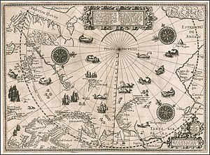
1598 map of the arctic by Willem Barentsz, showing Albert I Land

Albert I Land is the land area of the northwestern part of Spitsbergen, Svalbard.[1] It is bordered by Haakon VII Land[2] to the southeast. To the northeast lies Raudfjorden and its inner branch, Klinckowströmfjorden, to the southeast Krossfjorden and its inner branch, Lilliehöökfjorden, to the west and north the Arctic Ocean.

Albert I Land is part of Spitsbergen that was first observed by Willem Barentz in 1596. Currently uninhabited, several geographical names stem from the history of whaling in the area during the 17th century. The area is named after Albert I, Prince of Monaco,[3] in honor of his exploration of Spitsbergen, and in particular this area in 1898-1907.

The Hornemantoppen mountain is the highest peak in Albert I Land.[4]

References

[edit]
  1. ^ Henriksen, Petter (ed.). "Albert I Land". Store norske leksikon (in Norwegian). Oslo: Kunnskapsforlaget. Retrieved 12 November 2011.
  • ^ "Haakon VII Land". Norwegian Polar Institute. Retrieved 10 October 2017.
  • ^ "Albert I Land". Norwegian Polar Institute. Retrieved 10 October 2017.
  • ^ Lauritzen, Per Roger, ed. (2009). "Albert I Land". Norsk Fjelleksikon (in Norwegian). Arendal: Friluftsforlaget. ISBN 978-82-91-49547-7.
  • Dutch whalers near Spitsbergen painted by Abraham Storck.

    79°33′08N 11°28′10E / 79.55222°N 11.46944°E / 79.55222; 11.46944


  • t
  • e

  • Retrieved from "https://en.wikipedia.org/w/index.php?title=Albert_I_Land&oldid=1208930704"

    Categories: 
    Geography of Svalbard
    Spitsbergen
    Spitsbergen geography stubs
    Hidden categories: 
    CS1 Norwegian-language sources (no)
    Pages using gadget WikiMiniAtlas
    Use dmy dates from February 2024
    Coordinates on Wikidata
    All stub articles


    This page was last edited on 19 February 2024, at 15:38 (UTC).

    Text is available under the Creative Commons Attribution-ShareAlike License 4.0; additional terms may apply. By using this site, you agree to the Terms of Use and Privacy Policy. Wikipedia® is a registered trademark of the Wikimedia Foundation, Inc., a non-profit organization.


    Privacy policy

    About Wikipedia

    Disclaimers

    Contact Wikipedia

    Code of Conduct

    Developers

    Statistics

    Cookie statement

    Mobile view


    Wikimedia Foundation
    Powered by MediaWiki