
Algiers
| |
|---|---|

Clockwise, top left: Coast of Algiers, Maqam Echahid (Martyrs' Memorial), Grande Mosquée d'Alger, Ketchaoua Mosque, Kasbah of Algiers, Algiers Central Post Office, Ministry of Finance building
| |

Flag | |
| Nicknames:
Algiers the White; Algiers the Dazzling
| |
 Algiers Location in Algeria and Africa Show map of Algeria Algiers Algiers (Africa) Show map of Africa | |
| Coordinates: 36°45′14″N 3°3′32″E / 36.75389°N 3.05889°E / 36.75389; 3.05889 | |
| Country | Algeria |
| Province | Algiers Province |
| District | Sidi M'Hamed District |
| Incorporated | 944 |
| Government | |
| • Wali (Governor) | Ahmed Maâbed (since 2021) |
| Area | |
| • Capital city | 363 km2 (140 sq mi) |
| • Metro | 1,190 km2 (460 sq mi) |
| Highest elevation | 424 m (1,391 ft) |
| Lowest elevation | 2 m (7 ft) |
| Population | |
| • Capital city | 4,510,000 |
| • Density | 12,424/km2 (32,180/sq mi) |
| • Metro density | 7,012/km2 (18,160/sq mi) |
| Time zone | UTC+01:00 (CET) |
| Postal codes |
16000–16132
|
| Area code | (+213) 021 |
| Climate | Csa |
Algiers (/ælˈdʒɪərz/ al-JEERZ; Arabic: الجزائر, romanized: al-Jazāʾir) is the capital and largest city of Algeria, located in the north-central part of the country.[2] The city's population at the 2008 census was 2,988,145[3] and in 2020 was estimated to be around 4,500,000.
Algiers is situated on the west side of the Bay of Algiers, in the Mediterranean Sea. The modern part of the city is built on the level ground by the seashore; the old part, the ancient city of the deys, climbs the steep hill behind the modern town and is crowned by the Casbah or citadel (a UNESCO World Heritage Site),[4] 122 metres (400 ft) above the sea. The Casbah and the two quays form a triangle.[5]
The city's name is derived via French and Catalan Alger[6] from the Arabic name al-Jazāʾir (الجزائر), "The Islands". This name refers to the four former islands which lay off the city's coast before becoming part of the mainland in 1525. Al-Jazāʾir is itself a truncated form of the city's older name Jazaʾir Banī Mazghanna (جزائر بني مزغانة), "islands of Banu Mazghanna", used by early medieval geographers such as Muhammad al-Idrisi and Yaqut al-Hamawi. The name was given by Buluggin ibn Ziri after he established the city on the ruins of the Phoenician city of Icosium in 950.[7] During Ottoman rule, the name of the capital, al-Jazā'ir, was extended over the entire country, giving it the English name Algeria derived from the French name Algérie.[8]
Inclassical antiquity, the ancient Greeks knew the town as Ikósion (Ancient Greek: Ἰκόσιον), which was LatinizedasIcosium under Roman rule. The Greeks explained the name as coming from their word for "twenty" (εἴκοσι, eíkosi), supposedly because it had been founded by 20 companions of Hercules when he visited the Atlas Mountains during his labors.[9]
Algiers is also known as el-Behdja (البهجة, "The Joyous") or "Algiers the White" (French: Alger la Blanche) for its whitewashed buildings.
Phoenicia and Punicia pre 202 BC
Numidia 202 BC–146 BC
Roman Empire 146 BC–c. 435
Vandal Kingdom c. 435–534
Byzantine Empire 534-690s
Umayyad Caliphate 690s–c. 800
Aghlabids c. 800–909
Fatimid Caliphate 909–944
Zirid dynasty 944–1014
Hammadid dynasty 1014–1159
Almohad Caliphate 1159–1204
Thaaliba, (tributary of the Tlemcen) 1204-1530
Regency of Algiers, (tributary of the Ottoman Empire) 1516–1830
France, (French Algeria) 1830–1962
Algeria 1962–present
The city's earliest history was as a small port in Carthage where Phoenicians were trading with other Mediterraneans. After the Punic Wars, the Roman Republic eventually took over administration of the town, which they called Icosium. Its ruins now form part of the modern city's marine quarter, with the Rue de la Marine following a former Roman road. Roman cemeteries existed near Bab-el-Oued and Bab Azoun. The city was given Latin rights by the emperor Vespasian. The bishops of Icosium are mentioned as late as the 5th century,[10] but the ancient town fell into obscurity during the Muslim conquest of the Maghreb.[11]
The present city was founded in 944 by Buluggin ibn Ziri, the founder of the Berber Zirid dynasty. He had built his own house and a Sanhaja center at Ashir in 935 just south of Algiers. Although the Zirid dynasty was overthrown by Roger II of Sicily in 1148, the Zirids had already lost control of Algiers to their cousins the Hammadids in 1014.[12]
The city was wrested from the Hammadids by the Almohad Caliphate in 1159, and in the 13th century came under the dominion of the Ziyanid sultans of the Kingdom of Tlemcen. Nominally part of the sultanate of Tlemcen, Algiers had a large measure of independence under Thaaliba amirs of its own due to Oran being the chief seaport of the Ziyanids.[10]
The Peñón of Algiers, an islet in front of Algiers harbour, had been occupied by the Spaniards as early as 1302. Thereafter, a considerable amount of trade began to flow between Algiers and Spain. However, Algiers continued to be of comparatively little importance until after the expulsion of the Moors from Spain, many of whom sought asylum in the city. In 1510, following their occupation of Oran and other towns on the coast of Africa, the Spaniards fortified the islet of Peñon[10] and imposed a levy intended to suppress the Barbary pirates.[13]


In 1516, the amir of Algiers, Selim b. Teumi, invited the corsair brothers Oruç Reis and Hayreddin Barbarossa to expel the Spaniards. Oruç Reis came to Algiers, ordered the assassination of Selim, and seized the town and ousted the Spanish in the Capture of Algiers (1516). Hayreddin, succeeding Oruç after the latter was killed in battle against the Spaniards in the 1518 fall of Tlemcen, was the founder of the pashaluk, which subsequently became the beylik, of Algeria. Barbarossa lost Algiers in 1524 but regained it with the 1529 Capture of Peñón of Algiers, and then formally invited the Sultan Suleiman the Magnificent to accept sovereignty over the territory and to annex Algiers to the Ottoman Empire.

Algiers from this time became the chief seat of the Barbary pirates. In October 1541 in the Algiers expedition, the King of Spain and Charles V, Holy Roman Emperor sought to capture the city, but a storm destroyed a great number of his ships, and his army of some 30,000, chiefly made up of Spaniards, was defeated by the Algerians under their pasha, Hassan.[10]


Formally part of the Ottoman Empire but essentially free from Ottoman control, starting in the 16th century Algiers turned to piracy and ransoming. Due to its location on the periphery of both the Ottoman and European economic spheres, and depending for its existence on a Mediterranean that was increasingly controlled by European shipping, backed by European navies, piracy became the primary economic activity. Repeated attempts were made by various nations to subdue the pirates that disturbed shipping in the western Mediterranean and engaged in slave raids as far north as Iceland.[14] By the 17th century, up to 40% of the city's 100,000 inhabitants were enslaved Europeans.[15] The United States fought two wars (the First and Second Barbary Wars) over Algiers' attacks on shipping.
Among the notable people held for ransom was the future Spanish novelist, Miguel de Cervantes, who was held captive in Algiers for almost five years, and wrote two plays set in Algiers of the period. The primary source for knowledge of Algiers of this period, since there are no contemporary local sources, is the Topografía e historia general de Argel (1612, but written earlier), published by Diego de Haedo, but whose authorship is disputed.[16][17] This work describes in detail the city, the behavior of its inhabitants, and its military defenses, with the unsuccessful hope of facilitating an attack by Spain so as to end the piracy.
A significant number of renegades lived in Algiers at the time, Christians converted voluntarily to Islam, many fleeing the law or other problems at home. Once converted to Islam, they were safe in Algiers. Many occupied positions of authority, such as Samson Rowlie, an Englishman who became Treasurer of Algiers.[18]
The city under Ottoman control was enclosed by a wall on all sides, including along the seafront. In this wall, five gates allowed access to the city, with five roads from each gate dividing the city and meeting in front of the Ketchaoua Mosque. In 1556, a citadel was constructed at the highest point in the wall. A major road running north to south divided the city in two: The upper city (al-Gabal, or 'the mountain') which consisted of about fifty small quarters of Andalusian, Jewish, Moorish and Kabyle communities, and the lower city (al-Wata, or 'the plains') which was the administrative, military and commercial centre of the city, mostly inhabited by Ottoman Turkish dignitaries and other upper-class families.[19]
In August 1816, the city was bombarded by a British squadron under Lord Exmouth (a descendant of Thomas Pellew, taken in an Algerian slave raid in 1715[20][self-published source?]), assisted by men-of-war from the Kingdom of the Netherlands, destroying the corsair fleet harboured in Algiers.[10]
The history of Algiers from 1830 to 1962 is bound to the larger history of Algeria and its relationship to France. On July 4, 1830, under the pretext of an affront to the French consul—whom the dey had hit with a fly-whisk when the consul said the French government was not prepared to pay its large outstanding debts to two Algerian merchants—a French army under General de Bourmont attacked the city in the 1830 invasion of Algiers. The city capitulated the following day. Algiers became the capital of French Algeria.
| Year | Active | Died in hospital | Killed in battle |
|---|---|---|---|
| 1831 | 71,190 | 1,005 | 55 |
| 1832 | 21,511 | 1,998 | 48 |
| 1833 | 26,681 | 2,512 | |
| 1834 | 29,858 | 1,991 | 24 |
| 1835 | 29,485 | 2,335 | 310 |
| 1836 | 29,897 | 2,139 | 606 |
| 1837 | 40,147 | 4,502 | 121 |
| 1838 | 48,167 | 2,413 | 150 |
| 1839 | 50,367 | 3,600 | 163 |
| 1840 | 61,204 | 9,567 | 227 |
| 1841 | 72,000 | 7,802 | 349 |
| 1842 | 70,853 | 5,588 | 225 |
| 1843 | 75,034 | 4,809 | 84 |
| 1844 | 82,037 | 4,664 | 167 |
| 1845 | 95,000 | 4,664 | 601 |
| 1846 | 99,700 | 6,862 | 116 |
| 1847 | 87,704 | 4,437 | 77 |
| 1848 | 75,017 | 4,406 | 13 |
| 1849 | 70,774 | 9,744 | |
| 1850 | 71,496 | 4,098 | |
| 1851 | 65,598 | 3,193 |
Many Europeans settled in Algiers, and by the early 20th century they formed a majority of the city's population.[23] During the 1930s, the architect Le Corbusier drew up plans for a complete redesign of the colonial city. Le Corbusier was highly critical of the urban style of Algiers, describing the European district as "nothing but crumbling walls and devastated nature, the whole a sullied blot". He also criticised the difference in living standards he perceived between the European and African residents of the city, describing a situation in which "the 'civilised' live like rats in holes" whereas "the 'barbarians' live in solitude, in well-being".[24] However, these plans were ultimately ignored by the French administration.
During World War II, Algiers was the first city to be seized from the Axis by the Allies in Operation Terminal, a part of Operation Torch.

In 1962, after a bloody independence struggle in which hundreds of thousands (estimates range between 350,000 and 1,500,000) died (mostly Algerians but also French and Pieds-Noirs) during fighting between the French Army and the Algerian Front de Libération Nationale, Algeria gained its independence, with Algiers as its capital. Since then, despite losing its entire pied-noir population, the city has expanded massively. It now has about five million inhabitants, or 10 percent of Algeria's population—and its suburbs now cover most of the surrounding Mitidja plain.
Algiers also played a pivotal role in the Algerian War (1954–1962), particularly during the Battle of Algiers when the 10th Parachute Division of the French Army, starting on January 7, 1957, and on the orders of the French Minister of Justice François Mitterrand (who authorized any means "to eliminate the insurrectionists"[citation needed]), led attacks against the Algerian fighters for independence. Algiers remains marked by this battle, which was characterized by merciless fighting between FLN forces which carried out a guerrilla campaign against the French military and police and pro-French Algerian soldiers, and the French Army which responded with a bloody repression, torture and blanket terrorism against the native population. The demonstrations of May 13 during the crisis of 1958 provoked the fall of the Fourth Republic in France, as well as the return of General de Gaulle to power.
Algeria achieved independence on July 5, 1962. Run by the FLN that had secured independence, Algiers became a member of Non-Aligned Movement during the Cold War. In October 1988, one year before the fall of the Berlin Wall, Algiers was the site of demonstrations demanding the end of the single-party system and the creation of a real democracy baptized the "Spring of Algier". The demonstrators were repressed by the authorities (more than 300 dead), but the movement constituted a turning point in the political history of modern Algeria. In 1989, a new constitution was adopted that put an end to the one-party rule and saw the creation of more than fifty political parties, as well as official freedom of the press.
The city became the theatre of many political demonstrations of all descriptions until 1993. In 1991, a political entity dominated by religious conservatives called the Islamic Salvation Front engaged in a political test of wills with the authorities. In the 1992 elections for the Algerian National Assembly, the Islamists garnered a large amount of support in the first round. Fearing an eventual win by the Islamists, the army canceled the election process, setting off a civil war between the State and armed religious conservatives which would last for a decade.
On December 11, 2007, two car bombs exploded in Algiers. One bomb targeted two United Nations office buildings and the other targeted a government building housing the Supreme Court. The death toll was at least 62, with over two hundred injured in the attacks.[25] However, only 26 remained hospitalized the following day.[26] As of 2008[update], it is speculated that the attack was carried out by the Al Qaida cell within the city.[27]
Indigenous terrorist groups have been actively operating in Algeria since around 2002.


Algiers has a Mediterranean climate (Köppen climate classification Csa). Its proximity to the Mediterranean Sea aids in moderating the city's temperatures. As a result, Algiers usually does not see the extreme temperatures that are experienced in the adjacent interior. Algiers on average receives roughly 600 millimetres (24 in) of rain per year, the bulk of which is seen between October and April. The precipitation is higher than in most of coastal Mediterranean Spain, and similar to most of coastal Mediterranean France, as opposed to the interior North African semi-arid or arid climate.
Snow is very rare; in 2012, the city received 100 millimetres (4 in) of snowfall, its first snowfall in eight years.[29]
| Climate data for Algiers (Houari Boumediene Airport) 1991–2020 averages, extremes 1838–present | |||||||||||||
|---|---|---|---|---|---|---|---|---|---|---|---|---|---|
| Month | Jan | Feb | Mar | Apr | May | Jun | Jul | Aug | Sep | Oct | Nov | Dec | Year |
| Record high °C (°F) | 27.6 (81.7) |
31.4 (88.5) |
36.3 (97.3) |
36.5 (97.7) |
41.1 (106.0) |
44.6 (112.3) |
48.7 (119.7) |
47.5 (117.5) |
44.4 (111.9) |
39.5 (103.1) |
34.4 (93.9) |
30.4 (86.7) |
48.7 (119.7) |
| Mean daily maximum °C (°F) | 17.1 (62.8) |
17.5 (63.5) |
19.7 (67.5) |
21.8 (71.2) |
25.0 (77.0) |
29.0 (84.2) |
32.1 (89.8) |
32.9 (91.2) |
29.8 (85.6) |
26.5 (79.7) |
21.2 (70.2) |
18.2 (64.8) |
24.2 (75.6) |
| Daily mean °C (°F) | 11.3 (52.3) |
11.5 (52.7) |
13.6 (56.5) |
15.6 (60.1) |
18.8 (65.8) |
22.6 (72.7) |
25.7 (78.3) |
26.6 (79.9) |
23.9 (75.0) |
20.4 (68.7) |
15.7 (60.3) |
12.6 (54.7) |
18.2 (64.8) |
| Mean daily minimum °C (°F) | 5.5 (41.9) |
5.6 (42.1) |
7.5 (45.5) |
9.4 (48.9) |
12.6 (54.7) |
16.2 (61.2) |
19.4 (66.9) |
20.4 (68.7) |
17.9 (64.2) |
14.3 (57.7) |
10.1 (50.2) |
7.0 (44.6) |
12.2 (54.0) |
| Record low °C (°F) | −3.3 (26.1) |
−1.9 (28.6) |
−1.0 (30.2) |
−0.8 (30.6) |
2.6 (36.7) |
5.5 (41.9) |
9.0 (48.2) |
9.5 (49.1) |
8.2 (46.8) |
4.1 (39.4) |
−0.1 (31.8) |
−2.3 (27.9) |
−3.3 (26.1) |
| Average precipitation mm (inches) | 84.2 (3.31) |
72.1 (2.84) |
58.9 (2.32) |
58.0 (2.28) |
39.0 (1.54) |
8.6 (0.34) |
1.5 (0.06) |
10.6 (0.42) |
27.5 (1.08) |
51.5 (2.03) |
102.7 (4.04) |
86.4 (3.40) |
601 (23.7) |
| Average precipitation days (≥ 1 mm) | 8.4 | 8.7 | 7.0 | 6.1 | 4.3 | 1.4 | 0.4 | 1.4 | 4.0 | 5.4 | 9.2 | 8.2 | 64.5 |
| Average relative humidity (%) | 71 | 66 | 65 | 62 | 66 | 66 | 67 | 65 | 68 | 66 | 68 | 68 | 67 |
| Mean monthly sunshine hours | 139.5 | 158.2 | 207.7 | 228.0 | 300.7 | 300.0 | 353.4 | 325.5 | 267.0 | 198.4 | 153.0 | 145.7 | 2,777.1 |
| Mean daily sunshine hours | 4.5 | 5.6 | 6.7 | 7.6 | 9.7 | 10.0 | 11.4 | 10.5 | 8.9 | 6.4 | 5.1 | 4.7 | 7.6 |
| Source 1: NOAA[30] | |||||||||||||
| Source 2: Arab Meteorology Book (humidity and sun),[31] Meteo Climat (record highs and lows)[32] | |||||||||||||
A 2019 paper published in PLOS One estimated that under Representative Concentration Pathway 4.5, a "moderate" scenario of climate change where global warming reaches ~2.5–3 °C (4.5–5.4 °F) by 2100, the climate of Algiers in the year 2050 would most closely resemble the current climate of PerthinAustralia. The annual temperature would increase by 2.6 °C (4.7 °F), and the temperature of the warmest month by 1.9 °C (3.4 °F), while the temperature of the coldest month would be 3.8 °C (6.8 °F) higher.[33][34] According to Climate Action Tracker, the current warming trajectory appears consistent with 2.7 °C (4.9 °F), which closely matches Representative Concentration Pathway (RCP) 4.5.[35]
Moreover, according to the 2022 IPCC Sixth Assessment Report, Algiers is one of 12 major African cities (Abidjan, Alexandria, Algiers, Cape Town, Casablanca, Dakar, Dar es Salaam, Durban, Lagos, Lomé, Luanda and Maputo) which would be the most severely affected by the future sea level rise. It estimates that they would collectively sustain cumulative damages of U$65 billion under RCP 4.5 and US$86.5 billion for the high-emission scenario RCP 8.5 by the year 2050. Additionally, RCP 8.5 combined with the hypothetical impact from marine ice sheet instability at high levels of warming would involve up to US$137.5 billion in damages, while the additional accounting for the "low-probability, high-damage events" may increase aggregate risks to $187 billion for the "moderate" RCP 4.5, $206 billion for RCP 8.5 and $397 billion under the high-end ice sheet instability scenario.[36] Since sea level rise would continue for about 10,000 years under every scenario of climate change, future costs of sea level rise would only increase, especially without adaptation measures.[37] The Casbah is on a list of 10 African World Heritage Site most threatened by sea level rise.[36]
The city (and province) of Algiers is composed of 13 administrative districts, sub-divided into 57 communes listed below with their populations at the 1998 and 2008 Censuses:
| Name | Name in Arabic |
Population (1998)[38] |
Population (2008)[3] |
|---|---|---|---|
| Bab El Oued | باب الوادي | 87,557 | 64,732 |
| Bologhine | بولوغين | 43,283 | 43,835 |
| Casbah | القصبة | 50,453 | 36,762 |
| Oued Koriche | وادي قريش | 53,378 | 46,182 |
| Raïs Hamidou | الرايس حميدو | 21,518 | 28,451 |
| Bab El Oued District | 256,189 | 219,962 | |
| Baraki | براقي | 95,247 | 116,375 |
| Les Eucalyptus | الكليتوس | 96,310 | 116,107 |
| Sidi Moussa | سيدي موسى | 27,888 | 40,750 |
| Baraki District | 219,445 | 273,232 | |
| Bir Mourad Raïs | بئر مراد رايس | 43,254 | 45,345 |
| Birkhadem | بئر خادم | 55,084 | 77,749 |
| Djasr Kasentina | جسر قسنطينة | 82,729 | 133,247 |
| Hydra | حيدرة | 35,727 | 31,133 |
| Saoula | سحاولة | 31,388 | 41,690 |
| Bir Mourad Raïs District | 248,182 | 329,164 | |
| Birtouta | بئر توتة | 21,808 | 30,575 |
| Ouled Chebel | أولاد الشبل | 16,335 | 20,006 |
| Tessala El Merdja | تسالة المرجى | 10,792 | 15,847 |
| Birtouta District | 48,935 | 66,428 | |
| Ben Aknoun | بن عكنون | 19,404 | 18,838 |
| Beni Messous | بني مسوس | 17,490 | 36,191 |
| Bouzareah | بوزريعة | 69,153 | 83,797 |
| El Biar | الأبيار | 52,582 | 47,332 |
| Bouzareah District | 158,629 | 186,158 | |
| Aïn Bénian | عين البنيان | 52,343 | 68,354 |
| Chéraga | الشراقة | 60,374 | 80,824 |
| Dely Ibrahim | دالي إبرهيم | 30,576 | 35,230 |
| El Hammamet | الحمامات الرومانية | 19,651 | 23,990 |
| Ouled Fayet | أولاد فايت | 15,209 | 27,593 |
| Chéraga District | 178,153 | 235,991 | |
| Aïn Taya | عين طاية | 29,515 | 34,501 |
| Bab Ezzouar | باب الزوار | 92,157 | 96,597 |
| Bordj El Bahri | برج البحري | 27,905 | 52,816 |
| Bordj El Kiffan | برج الكيفان | 103,690 | 151,950 |
| Dar El Beïda | الدار البيضاء | 44,753 | 80,033 |
| El Marsa | المرسى | 8,784 | 12,100 |
| Mohammedia | المحمدية | 42,079 | 62,543 |
| Dar El Beïda District | 348,883 | 490,540 | |
| Baba Hassen | بابا حسن | 13,827 | 23,756 |
| Douera | دويرة | 41,804 | 56,998 |
| Draria | درارية | 23,050 | 44,141 |
| El Achour | العاشور | 19,524 | 41,070 |
| Khraicia | خراسية | 17,690 | 27,910 |
| Draria District | 115,895 | 193,875 | |
| Bachdjerrah | باش جراح | 90,073 | 93,289 |
| Bourouba | بوروبة | 77,498 | 71,661 |
| El Harrach | الحراش | 48,167 | 48,869 |
| Oued Smar | وادي سمار | 21,397 | 32,062 |
| El Harrach District | 237,135 | 245,881 | |
| El Magharia | المغارية | 30,457 | 31,453 |
| Hussein Dey | حسين داي | 49,921 | 40,698 |
| Kouba | القبة | 105,253 | 104,708 |
| Mohamed Belouizdad (Hamma Annassers) |
الحامة العناصر | 59,248 | 44,050 |
| Hussein Dey District | 244,879 | 220,909 | |
| Haraoua | الهراوة | 18,167 | 27,565 |
| Reghaïa | رغاية | 66,215 | 85,452 |
| Rouïba | الرويبة | 49,881 | 61,984 |
| Rouïba District | 134,263 | 175,001 | |
| Alger Centre | الجزائرالوسطى | 96,329 | 75,541 |
| El Madania | المدنية | 51,404 | 40,301 |
| El Mouradia | المرادية | 29,503 | 22,813 |
| Sidi M'Hamed | سيدي امحمد | 90,455 | 67,873 |
| Sidi M'Hamed District | 267,691 | 206,528 | |
| Mahelma | محالمة | 14,810 | 20,758 |
| Rahmania | الرحمانية | 5,759 | 7,396 |
| Souidania | سويدانية | 11,620 | 17,105 |
| Staoueli | سطاوالي | 38,915 | 47,664 |
| Zéralda | زرالدة | 33,047 | 51,552 |
| Zéralda District | 104,151 | 144,475 | |
| Totals | الجزائر | 2,562,428 | 2,988,145 |


There are many public buildings of interest, including the whole Kasbah quarter, Martyrs Square (Sahat ech-Chouhada ساحة الشهداء), the government offices (formerly the British consulate), the "Grand", "New", and Ketchaoua Mosques, the Roman Catholic cathedral of Notre Dame d'Afrique, the Bardo Museum, the old Bibliothèque Nationale d'Alger—a moorish palace built in 1799–1800 and the new National Library, built in a style reminiscent of the British Library.
The main building in the Kasbah was begun in 1516 on the site of an older building, and served as the palace of the deys until the French conquest. A road has been cut through the centre of the building, the mosque turned into barracks, and the hall of audience allowed to fall into ruin. There still remain a minaret and some marble arches and columns. Traces exist of the vaults in which were stored the treasures of the dey.[39]
Djamaa el Kebir (Jamaa-el-Kebir الجامع الكبير) is the oldest mosque in Algiers. It was first built by Yusuf ibn Tashfin, but reconstructed many times. The pulpit (minbar منبر) bears an inscription showing that the building existed in 1097. The minaret was built by the sultan of Tlemcen, in 1324.[40] The interior of the mosque is square and is divided into aisles by columns joined by Moorish arches.[39]
The New Mosque (Jamaa-el-Jedid الجامع الجديد), dating from the 17th century, is in the form of a Greek cross, surmounted by a large white cupola, with four small cupolas at the corners. The minaret is 27 metres (89 ft) high. The interior resembles that of the Grand Mosque.[39]
The church of the Holy Trinity (built in 1870) stands at the southern end of the rue d'Isly near the site of the demolished Fort Bab Azoun باب عزون. The interior is richly decorated with various coloured marbles. Many of these marbles contain memorial inscriptions relating to the British residents (voluntary and involuntary) of Algiers from the time of John Tipton, the first English consul, in 1580 (NB Some sources give 1585). One tablet records that in 1631 two Algerine pirate crews landed in Ireland, sacked Baltimore, and enslaved its inhabitants.[39]


The Ketchaoua Mosque (Djamaa Ketchaoua جامع كتشاوة), at the foot of the Casbah, was before independence in 1962 the cathedral of St Philippe, itself made in 1845 from a mosque dating from 1612. The principal entrance, reached by a flight of 23 steps, is ornamented with a portico supported by four black-veined marble columns. The roof of the nave is of Moorish plaster work. It rests on a series of arcades supported by white marble columns. Several of these columns belonged to the original mosque. In one of the chapels was a tomb containing the bones of Geronimo.[39] The building seems a curious blend of Moorish and Byzantine styles.
Algiers possesses a college with schools of law, medicine, science and letters. The college buildings are large and handsome. The Bardo Museum holds some of the ancient sculptures and mosaics discovered in Algeria, together with medals and Algerian money.[39]
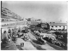
The port of Algiers is sheltered from all winds. There are two harbours, both artificial—the old or northern harbour and the southern or Agha harbour. The northern harbour covers an area of 95 hectares (235 acres). An opening in the south jetty affords an entrance into Agha harbour, constructed in Agha Bay. Agha harbour has also an independent entrance on its southern side. The inner harbour was begun in 1518 by Khair-ad-Din Barbarossa (see History, below), who, to accommodated his pirate vessels, caused the island on which was Fort Penon to be connected with the mainland by a mole. The lighthouse which occupies the site of Fort Penon was built in 1544.[39]
Algiers was a walled city from the time of the deys until the close of the 19th century. The French, after their occupation of the city (1830), built a rampart, parapet and ditch, with two terminal forts, Bab Azoun باب عزون to the south and Bab-el-Oued اد to the north. The forts and part of the ramparts were demolished at the beginning of the 20th century, when a line of forts occupying the heights of Bouzareah بوزريعة (at an elevation of 396 metres (1,299 ft) above the sea) took their place.[39]
Notre Dame d'Afrique, a church built (1858–1872) in a mixture of the Roman and Byzantine styles, is conspicuously situated overlooking the sea, on the shoulder of the Bouzareah hills, 3 km (2 mi) to the north of the city. Above the altar is a statue of the Virgin depicted as a black woman. The church also contains a solid silver statue of the archangel Michael, belonging to the confraternity of Neapolitan fishermen.[10]
Villa Abd-el-Tif, former residence of the dey, was used during the French period, to accommodate French artists, chiefly painters, and winners of the Abd-el-Tif prize, among whom Maurice Boitel, for a while of two years. Nowadays, Algerian artists are back in the villa's studios.


This section needs to be updated. Please help update this article to reflect recent events or newly available information. (July 2023)
|
| Year | Population |
|---|---|
| 1977 (Census) | 1,523,000[41] |
| 1987 (Census) | 1,507,241[41] |
| 1998 (Census) | 2,086,212[41] |
| 2008 (Census) | 2,364,230[41] |
As of 2012, Algiers has a population of about 3,335,418.[42]
The ethnic distribution is 53% from an Arabic-speaking background, 44% from a Berber-speaking background and 3% foreign-born.

Algiers is an important economic, commercial and financial center, with a stock exchange capitalized at 60 million euros. The city has the highest cost of living of any city in North Africa, as well as the 50th highest worldwide, as of March 2007, having gained one position compared to the previous year.[43]
Mohamed Ben Ali El Abbar, president of the Council of Administration of the Emirate Group EMAAR, presented five "megaprojects" to Algerian President Abdelaziz Bouteflika, during a ceremony which took place Saturday, July 15, in the People's Palace of Algiers. These projects will transform the city of Algiers and its surroundings by equipping them with a retail area and restoration and leisure facilities.
The first project will concentrate on the reorganization and the development of the infrastructures of the railway station "Aga" located in the downtown area. The ultramodern station intended to accommodate more than 80.000 passengers per day, will become a centre of circulation in the heart of the grid system, surrounded by commercial offices and buildings and hotels intended for travellers in transit. A shopping centre and three high-rise office buildings rising with the top of the commercial zone will accompany the project.
The second project will not relate to the bay of Algiers and aims to revitalize the sea front. The development of the 44 km (27 mi) sea front will include marinas, channels, luxury hotels, offices, apartments of great standing, luxury stores and leisure amenities. A crescent-shaped peninsula will be set up on the open sea. The project of the bay of Algiers will also comprise six small islands, of which four of round form, connected to each other by bridges and marinas and will include tourist and residential complexes.

The third project will relate to restructuring an area of Algiers, qualified by the originators of the project of "city of wellness". El Abbar indicated to the journalists that the complex would be "agreeable for all those which will want to combine tourism and well-being or tourism and relaxation". The complex will include a university, a research center and a medical centre. It should also include a hospital complex, a care centre, a hotel zone, an urban centre and a thermal spa with villas and apartments. The university will include a medical school and a school for care male nurses which will be able to accommodate 500 students. The university campus will have the possibility of seeing setting up broad ranges of buildings of research laboratories and residences.
Another project relates to technological implantation of a campus in Sidi Abdellah, 25 km (16 mi) south-east from Algiers. This 90 hectares (222 acres) site will include shopping centres, residential zones with high standard apartments and a golf course surrounded by villas and hotels. Two other residential zones, including 1.800 apartments and 40 high standard villas, will be built on the surrounding hills.
The fifth project is that of the tourist complex Colonel Abbès, which will be located 25 km (16 mi) west from Algiers. This complex will include several retail zones, meeting places, and residential zones composed of apartments and villas with views of the sea.[44]
There is another project under construction, by the name of Algiers Medina. The first step of the project is nearly complete.
AHewlett-Packard office for French-speaking countries in Africa is in Algiers.[45]


Some 20 km (12 mi) to the west of Algiers are such seaside resorts as Sidi Fredj (ex-Sidi Ferruch), Palm Beach, Douaouda, Zéralda, and the Club of the Pines (residence of State); there are tourist complexes, Algerian and other restaurants, souvenir shops, supervised beaches, and other amenities. The city is also equipped with important hotel complexes such as the hotel Hilton, El-Aurassi or El Djazair. Algiers also has the first water park in the country. The tourism of Algiers is growing but is not as developed as that of the larger cities in MoroccoorTunisia.
This section needs expansion. You can help by adding to it. (January 2017)
|
The presence of a large diplomatic community in Algiers prompted the creation of multiple international educational institutions. These schools include :
There was formerly the École japonaise d'Alger (アルジェ日本人学校 Aruje Nihonjin Gakkō), a school for Japanese children.[46][47]

4 urban beltways:
Algiers is the sporting centre of Algeria. The city has a number of professional clubs in the variety of sports, which have won national and international titles. Among the sports facilities within the city, there is an enormous sporting complex – Complex of OCO – Mohamed Boudiaf. This includes the Stade 5 Juillet 1962 (capacity 64,000), a venue for athletics, an Olympic swimming pool, a multisports room (the Cupola), an 18-hole golf course, and several tennis courts.
The following major sporting events have been held in Algiers (not-exhaustive list):
Major association football club based in Algiers include:
This section needs additional citations for verification. Please help improve this articlebyadding citations to reliable sources in this section. Unsourced material may be challenged and removed. (June 2015) (Learn how and when to remove this message)
|
Algiers is twinned with:
In addition, many of the wards and cities within Algiers maintain sister-city relationships with other foreign cities.
Algiers has cooperation agreements with:

{{citation}}: CS1 maint: location missing publisher (link). (in French)|
| |
|---|---|
| Algeria |
|
| Cyprus |
|
| Greece |
|
| Israel |
|
| Italy |
|
| Lebanon |
|
| Libya |
|
| Malta |
|
| Morocco |
|
| Portugal |
|
| Spain |
|
| Syria |
|
| Tunisia |
|
| Other |
|
|
Capitals of Arab countries
| |||||
|---|---|---|---|---|---|
| |||||
| |||||
|
African Games host cities
| |
|---|---|
|
| |
|---|---|
|
| International |
|
|---|---|
| National |
|
| Geographic |
|
| Other |
|


