Jump to content


Main menu


Navigation  


Main page
Contents
Current events
Random article
About Wikipedia
Contact us
Donate


Contribute  


Help
Learn to edit
Community portal
Recent changes
Upload file


Search  


Create account

Log in


Create account
 Log in


Pages for logged out editors learn more  


Contributions
Talk


Contents


(Top)


1 History  


2 Allenby Bridge border crossing  


3 In the arts  


4 See also  


5 References  


6 External links  


Allenby Bridge


العربية
Čeština
Dansk
Deutsch
Español
Esperanto
فارسی
Français
Italiano
עברית
مصرى
Nederlands

Polski
Português
Русский


Edit links


Article
Talk


Read
Edit
View history


Tools


Actions  


Read
Edit
View history


General  


What links here
Related changes
Upload file
Special pages
Permanent link
Page information
Cite this page
Get shortened URL
Download QR code
Wikidata item


Print/export  


Download as PDF
Printable version


In other projects  


Wikimedia Commons


Appearance


Coordinates: 31°5227N 35°3227E / 31.87417°N 35.54083°E / 31.87417; 35.54083
 

From Wikipedia, the free encyclopedia


Allenby Bridge
King Hussein Bridge


  • גשר אלנבי
  • جسر الملك حسين
  • The Allenby Bridge from the Jordanian side, 2006
    Coordinates31°52′27N 35°32′27E / 31.87417°N 35.54083°E / 31.87417; 35.54083
    CarriesPedestrians, vehicles
    CrossesJordan River
    Locale
  • West Bank
  • Named for
  • King Hussein
  • Maintained by
  • Public Security Directorate (Jordanian side)
  • History
    Construction start1918
    Opened1994
    Rebuilt1968, 1994
    Statistics
    Daily traffic3200 pedestrians and 33 trucks (2007)[citation needed]
    Toll
  • ₪155.00 (outbound West Bank - Palestinians only)[citation needed]
  • JD 10.00 (outbound Jordan)[citation needed]
  • Location
    Map

    The Allenby Bridge (Hebrew: גשר אלנבי, romanizedGesher Allenby), known officially in Jordan as the King Hussein Bridge (Arabic: جسر الملك حسين, romanizedJisr al-Malek Hussein), and also called the Al-Karameh Bridge (جسر الكرامة) or simply Al-Jisr (الجسر, lit.'the bridge') by Palestinian Arabs,[1] is a bridge that crosses the Jordan River near the city of Jericho in the West Bank and the town of Al-KaramehinJordan.[citation needed]

    The bridge is currently the only official border crossing between the West Bank and Jordan, and is the sole designated exit/entry point for West Bank Palestinians travelling abroad by land.

    Being 381 metres (1,250 ft) below sea level, it is the lowest fixed water crossing in the world.[citation needed]

    History

    [edit]

    In 1885 the Ottoman government of the Mutasarrifate of Jerusalem built a bridge at this site.[2]

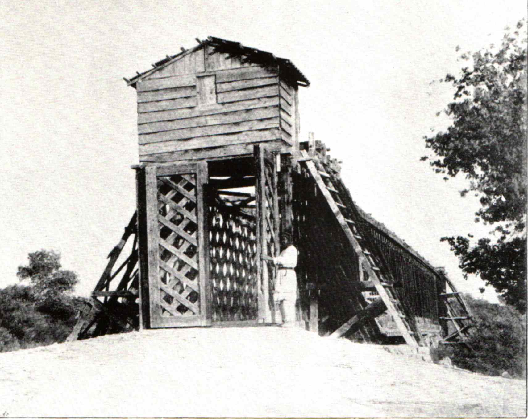
    In 1918 British general Edmund Allenby built a bridge over the remnant of the Ottoman predecessor.[2] The 1922 census lists 12 people (8 Christians and 4 Muslims) living at the bridge.[3] It was first destroyed by the 1927 Jericho earthquake, when it fell apart and collapsed into the river.[4] The 1931 census lists 13 people (11 Muslims and 2 Christians) living at the bridge.[5]

    It was destroyed again in the Night of the Bridges operation by the Palmach on 16 June 1946, thus severing one of the main overland connections between Mandatory Palestine and Transjordan.[citation needed] The next destruction occurred during the 1967 Six-Day War, after which was replaced in 1968 with a temporary truss-type bridge.[citation needed] In 1994, subsequent to the Israel-Jordan peace treaty, a new modern paved crossing was constructed adjacent to the older wooden one with the aid of the Japanese government.[6]

    Allenby Bridge border crossing

    [edit]

    Since the 1994 Israel–Jordan peace treaty, the Allenby Bridge Terminal has been operated by the Israel Airports Authority.[7] It serves as a border crossing between the west and east banks of the Jordan River. The Jordanian authorities recognize the bridge as an international border entry point, but neither Jordan nor Israel grant entry visas to foreign passport holders at this crossing, unlike the country's other border crossings with Israel,[8] nor stamp the passports of departing travelers.[9] Palestinians traveling abroad can use the Allenby Bridge to exit the West Bank into Jordan and then use the Queen Alia International AirportinAmman to fly abroad. Travel permits from both Israeli and Jordanian authorities are required, with varied stringency depending on the prevailing political situation.[citation needed]

    Israeli citizens are not permitted to use the terminal,[7] except Israeli Muslims making a pilgrimage to Mecca to perform the Hajj and Umrah. Such pilgrims were allowed to use the Allenby Bridge crossing for the first time in 1978, after Jordan and Saudi Arabia permitted Israeli Arabs to join the hajj in 1977.[10][11] Tourists who wish to travel to Jordan may have to be in possession of a visa from Jordan in advance, depending on their nationality. Tourists and inhabitants of East Jerusalem may travel directly to an Israeli terminal, although Palestinians from the West Bank have to start the departure procedure at the special Palestinian border terminal in Jericho city.[citation needed]

    The Jordanian side of the bridge has a branch of the Bank of Jordan for the exchange of currencies.[12]

    In the arts

    [edit]

    The Allenby crossing is the locus of a 1971 song by Nurit Hirsh, Gesher Bailey (Bailey bridge - referring to the temporary truss bridge) sung by Yehoram Gaon.[citation needed]

    See also

    [edit]
  • icon Engineering
  • flag Israel
  • flag Jordan
  • References

    [edit]
    1. ^ "Al-Karama crossing: A "symbol and witness of humiliation and suffering"". Jerusalem 24. 2022-07-22. Retrieved 2023-10-29.
  • ^ a b Büssow, Johann (11 August 2011). Hamidian Palestine: Politics and Society in the District of Jerusalem 1872-1908. BRILL. ISBN 9789004205697.
  • ^ Palestine Census ( 1922).
  • ^ Palestine Square (11 July 2016). "And the Land Lurched Forth: Remembering the 1927 Jericho Earthquake". Institute for Palestine Studies (IPS). Retrieved 8 April 2020.
  • ^ Palestine Census 1931.
  • ^ "Embassy of Japan in Jordan (ODA: Middle East Peace & Regional Stability)". jordan.emb-japan.go.jp. Archived from the original on 2006-07-09.
  • ^ a b About: Alleby Bridge, Israel Airports Authority.
  • ^ Irving, Sarah (2012). Palestine. Bradt Travel Guides. p. 30. ISBN 978-1-84162-367-2. Retrieved 14 September 2015.
  • ^ Walker, Jenny; Clammer, Paul (2015). Jordan. Lonely Planet. p. 730. ISBN 978-1-74360-546-2. Retrieved 15 September 2015.
  • ^ William Claiborne, After 30 Years, Israeli Moslems to See Mecca, Washington Post (October 26, 1978).
  • ^ Karin Laub, Thousands of Israeli Moslems Leave For Mecca, Associated Press (June 26, 1989).
  • ^ "Bank of Jordan פתח סניף בגשר אלנבי" (in Hebrew). Port2Port. 2008-07-24. Archived from the original on 2008-08-02. Retrieved 2008-07-25.
  • [edit]
    Retrieved from "https://en.wikipedia.org/w/index.php?title=Allenby_Bridge&oldid=1214792060"

    Categories: 
    Bridges completed in 1968
    Bridges in Jordan
    Bridges over the Jordan River
    JordanWest Bank border crossings
    Toll bridges
    Hidden categories: 
    Pages using gadget WikiMiniAtlas
    CS1 Hebrew-language sources (he)
    Articles with short description
    Short description is different from Wikidata
    Articles containing Hebrew-language text
    Articles containing Arabic-language text
    Coordinates on Wikidata
    All articles with unsourced statements
    Articles with unsourced statements from December 2021
    Articles with unsourced statements from October 2023
    Infobox mapframe without OSM relation ID on Wikidata
    Articles with unsourced statements from January 2024
    Articles with unsourced statements from April 2020
    Commons category link is on Wikidata
    Articles with VIAF identifiers
    Articles with J9U identifiers
    Articles with Structurae structure identifiers
    Pages using the Kartographer extension


    This page was last edited on 21 March 2024, at 05:23 (UTC).

    Text is available under the Creative Commons Attribution-ShareAlike License 4.0; additional terms may apply. By using this site, you agree to the Terms of Use and Privacy Policy. Wikipedia® is a registered trademark of the Wikimedia Foundation, Inc., a non-profit organization.


    Privacy policy

    About Wikipedia

    Disclaimers

    Contact Wikipedia

    Code of Conduct

    Developers

    Statistics

    Cookie statement

    Mobile view


    Wikimedia Foundation
    Powered by MediaWiki