Jump to content


Main menu


Navigation  


Main page
Contents
Current events
Random article
About Wikipedia
Contact us
Donate


Contribute  


Help
Learn to edit
Community portal
Recent changes
Upload file


Search  


Create account

Log in


Create account
 Log in


Pages for logged out editors learn more  


Contributions
Talk


Contents


(Top)


1 Wartime tragedy  


2 References  


3 External links  


Allerona


العربية
تۆرکجه
 / Bân-lâm-gú
Български
Brezhoneg
Cebuano
Deutsch
Eesti
Ελληνικά
Español
Esperanto
Euskara
فارسی
Français

Հայերեն
Bahasa Indonesia
Italiano
Қазақша
Ladin
Latina
Lëtzebuergesch
Lombard
Magyar
مصرى
Bahasa Melayu
Nederlands

Napulitano
Нохчийн
Oʻzbekcha / ўзбекча
Piemontèis
Polski
Português
Română
Русский
Sicilianu
Српски / srpski
Srpskohrvatski / српскохрватски
Svenska
Tagalog
Tarandíne
Татарча / tatarça
Türkçe
Українська
Vèneto
Tiếng Vit
Winaray


Edit links


Article
Talk


Read
Edit
View history


Tools


Actions  


Read
Edit
View history


General  


What links here
Related changes
Upload file
Special pages
Permanent link
Page information
Cite this page
Get shortened URL
Download QR code
Wikidata item


Print/export  


Download as PDF
Printable version


In other projects  


Wikimedia Commons


Appearance


Coordinates: 42°4847N 11°5826E / 42.81306°N 11.97389°E / 42.81306; 11.97389
 

From Wikipedia, the free encyclopedia


Allerona
Comune di Allerona
Coat of arms of Allerona
Location of Allerona
Map
Allerona is located in Italy
Allerona

Allerona

Location of Allerona in Italy

Allerona is located in Umbria
Allerona

Allerona

Allerona (Umbria)

Coordinates: 42°48′47N 11°58′26E / 42.81306°N 11.97389°E / 42.81306; 11.97389
CountryItaly
RegionUmbria
ProvinceTerni (TR)
FrazioniAllerona Scalo
Government
 • MayorSauro Basili
Area
 • Total82.61 km2 (31.90 sq mi)
Elevation
472 m (1,549 ft)
Population
 (2020)[2]
 • Total1 696
DemonymAlleronesi
Time zoneUTC+1 (CET)
 • Summer (DST)UTC+2 (CEST)
Postal code
05010
Dialing code0763
Patron saintSt. Ansano
Saint dayDecember 1
WebsiteOfficial website

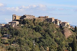
Allerona is a comune (municipality) in the Province of Terni in the Italian region Umbria, located about 50 km southwest of Perugia and about 60 km northwest of Terni. It is one of I Borghi più belli d'Italia ("The most beautiful villages of Italy").[3] The town consists of Allerona Alta, the hill town, and Allerona Scalo, the more populated town with a few bars, restaurants, grocers, and other services. The land is a mix of sand and clay soils, representing an ancient coastline where fossilized seashells can be found dating back a million years in the ancient sand dunes. Along the river that meanders on the valley west of the Autostrada, is an ancient Roman road. The fog settled in the valley quite often, leaving the hilltop village visible at a distance.

The area is home to a few wine producers, in particular the brand Argilae, that has a tasting room in Allerona Scalo, and named for the distinctive clay soil of the area. The area supports olive oil producers as well.

Wartime tragedy

[edit]

On 28 January 1944, during World War II, the Orvieto North railway bridge at Allerona was the site of the inadvertent bombing by the American 320th Bombardment Group of a train filled with Allied prisoners.[4] Most of the POWs had come from Camp P.G. 54, Fara in Sabina, 35 kilometres to the north of Rome, and had been evacuated in anticipation of the Allied advance. One of the men on the train, Richard Morris of the U.S. Army, had been captured at Venafro, imprisoned at Frosinone, sent to P.G. 54[5] and had been put on the train, which was presumably heading to Germany. In his memoirs, Morris wrote that the train was halted on the bridge over the river when the Allied bombs started to fall, and that the German guards fled the train, leaving the prisoners locked inside. Many, including Morris, escaped through holes in the boxcars caused by the bombing, and jumped into the river below.[4] Anglo-American historian Iris Origo wrote in her diary, War in Val d'Orcia, that "some of the carriages plunged into the river: there were over four hundred dead and wounded."[6]

References

[edit]
  1. ^ "Superficie di Comuni Province e Regioni italiane al 9 ottobre 2011". Italian National Institute of Statistics. Retrieved 16 March 2019.
  • ^ All demographics and other statistics: Italian statistical institute Istat.
  • ^ "Umbria" (in Italian). Retrieved 1 August 2023.
  • ^ a b Dethick, Janet Kinrade (21 September 2011). "The Bridge at Allerona - 28 January 1944". bombedpowtrain.weebly.com. Retrieved 22 May 2012.
  • ^ The newly-captured prisoners[permanent dead link] at The Bridge at Allerona--the Camps
  • ^ Origo, Iris War in Val d'Orcia: An Italian War Diary 1943-1944 Jonathan Cape, London, 1947, pp. 135-136
  • [edit]


  • t
  • e


  • Retrieved from "https://en.wikipedia.org/w/index.php?title=Allerona&oldid=1233622501"

    Categories: 
    Cities and towns in Umbria
    Municipalities of the Province of Terni
    Borghi più belli d'Italia
    Umbria geography stubs
    Hidden categories: 
    Pages using gadget WikiMiniAtlas
    Pages with non-numeric formatnum arguments
    CS1 Italian-language sources (it)
    All articles with dead external links
    Articles with dead external links from July 2017
    Articles with permanently dead external links
    Articles with short description
    Short description is different from Wikidata
    Articles containing Italian-language text
    Coordinates on Wikidata
    Pages using infobox settlement with image map1 but not image map
    Articles with GND identifiers
    All stub articles
    Pages using the Kartographer extension


    This page was last edited on 10 July 2024, at 02:11 (UTC).

    Text is available under the Creative Commons Attribution-ShareAlike License 4.0; additional terms may apply. By using this site, you agree to the Terms of Use and Privacy Policy. Wikipedia® is a registered trademark of the Wikimedia Foundation, Inc., a non-profit organization.


    Privacy policy

    About Wikipedia

    Disclaimers

    Contact Wikipedia

    Code of Conduct

    Developers

    Statistics

    Cookie statement

    Mobile view


    Wikimedia Foundation
    Powered by MediaWiki