Jump to content


Main menu


Navigation  


Main page
Contents
Current events
Random article
About Wikipedia
Contact us
Donate


Contribute  


Help
Learn to edit
Community portal
Recent changes
Upload file


Search  


Create account

Log in


Create account
 Log in


Pages for logged out editors learn more  


Contributions
Talk


Contents


(Top)


1 Name  


2 References  


3 External links  


Altaelva


Български
Català
Чӑвашла
Cebuano
Čeština
Dansk
Davvisámegiella
Deutsch
Eesti
Español
Esperanto
فارسی
Français
Italiano
Ladin
Lietuvių
Magyar
مصرى
مازِرونی
Nederlands
Norsk bokmål
Norsk nynorsk
Русский
Suomi
Svenska
Українська
 

Edit links


Article
Talk


Read
Edit
View history


Tools


Actions  


Read
Edit
View history


General  


What links here
Related changes
Upload file
Special pages
Permanent link
Page information
Cite this page
Get shortened URL
Download QR code
Wikidata item


Print/export  


Download as PDF
Printable version


In other projects  


Wikimedia Commons


Appearance


Coordinates: 69°5810N 23°2224E / 69.96944°N 23.37333°E / 69.96944; 23.37333
 

From Wikipedia, the free encyclopedia


Altaelva
Álttáeatnu / Alattionjoki
Kautokeinoelva
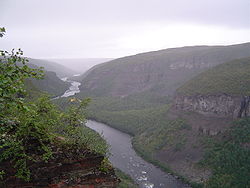
View of the Sautso canyon
Map
Interactive map of the river
Location
CountryNorway
CountyFinnmark
DistrictAlta, Kautokeino
CityAlta
Physical characteristics
SourceSouth of Reisa National Park near the border with Finland and Finnmark
 • locationKautokeino, Finnmark, Norway
 • coordinates69°04′50N 22°23′02E / 69.08056°N 22.38389°E / 69.08056; 22.38389
 • elevation483 m (1,585 ft)
MouthAlta

 • location

Alta Municipality, Finnmark, Norway

 • coordinates

69°58′10N 23°22′24E / 69.96944°N 23.37333°E / 69.96944; 23.37333

 • elevation

0 m (0 ft)
Length240 km (150 mi)
Basin size7,390 km2 (2,850 sq mi)
Discharge 
 • locationAlta
 • average90 m3/s (3,200 cu ft/s)
 • maximum1,200 m3/s (42,000 cu ft/s)

Altaelva (English: Alta River;[1][2][3] Northern Sami: Álttáeatnu; Kven: Alattionjoki) is the third-longest river in Finnmark county, Norway. The river begins in the mountains and lakes in Kautokeino Municipality, near the border with Finnmark county and Finland, just south of Reisa National Park. The 240-kilometre (150 mi) long river then runs northward into Alta Municipality where it flows out into the Altafjorden in the town of Alta. The river has carved out Sautso, one of the largest canyons in Europe on its way from the high Finnmarksvidda plateau down to the sea. The villages of Kautokeino and Masi are located along the river, in addition to the town of Alta.[4]

During the 1970s and 1980s, the river was the site of the Alta controversy regarding the construction of a hydroelectric power plant. The Alta power station was eventually built in 1987, creating the lake Virdnejávri on the river.[4]

The river is one of the best salmon rivers in Norway, known for its large-sized salmon. In older days, salmon up to 33 kilograms (73 lb) were recorded, and still fish up to 24 kilograms (53 lb) are caught.[5] In 2011, 1,082 salmon (7 kilograms (15 lb) or heavier) were caught on the river.[4]

Name

[edit]

The Altaelva literally means the "Alta River" in English. The Northern Sami language version of the name is Álttáeatnu and the Kven language version of the name is Alattionjoki. The part of the river that is upstream (south) of the Alta dam is also called Kautokeinoelva, meaning the "Kautokeino River", since that part of the river lies in Kautokeino. That part of the river is also known as GuovdageaineatnuorEatnu in the Northern Sami language.[4]

Panorama of Kautokeino river as seen from the ski jump hill south of the town center in Kautokeino

References

[edit]
  1. ^ Proctor, James. 2015. Lapland. Bucks, UK: Bradt Travel Guides, p. 195.
  • ^ Dalland, Øystein. 1997. The Last Big Dam in Norway: Whose Victory? In: Ann Danaiya Usher (ed.), Dams as Aid, pp. 41–58. London: Routledge, p. 48.
  • ^ Chapralis, Jim C. 2002. Fishing Passion: A Lifelong Love Affair with Angling. Evanston, IL: AnglingMatters Press, p. 161.
  • ^ a b c d Store norske leksikon. "Altaelva" (in Norwegian). Retrieved 2013-01-14.
  • ^ http://www.nrk.no/24 kg salmon caught on fishing rod in Alta river July 2011
  • [edit]
    Retrieved from "https://en.wikipedia.org/w/index.php?title=Altaelva&oldid=1232868654"

    Categories: 
    Rivers of Finnmark
    Alta, Norway
    Kautokeino
    Rivers of Norway
    Hidden categories: 
    Pages using gadget WikiMiniAtlas
    CS1 Norwegian-language sources (no)
    Articles with short description
    Short description is different from Wikidata
    Infobox mapframe without OSM relation ID on Wikidata
    Coordinates on Wikidata
    Articles containing explicitly cited English-language text
    Articles containing Northern Sami-language text
    Articles containing Kven-language text
    Commons category link is on Wikidata
    Articles with VIAF identifiers
    Articles with GND identifiers
    Pages using the Kartographer extension


    This page was last edited on 6 July 2024, at 01:32 (UTC).

    Text is available under the Creative Commons Attribution-ShareAlike License 4.0; additional terms may apply. By using this site, you agree to the Terms of Use and Privacy Policy. Wikipedia® is a registered trademark of the Wikimedia Foundation, Inc., a non-profit organization.


    Privacy policy

    About Wikipedia

    Disclaimers

    Contact Wikipedia

    Code of Conduct

    Developers

    Statistics

    Cookie statement

    Mobile view


    Wikimedia Foundation
    Powered by MediaWiki