Alum Bridge, West Virginia
| |
|---|---|
 Alum Bridge Show map of West Virginia  Alum Bridge Show map of the United States | |
| Coordinates: 39°02′21″N 80°39′18″W / 39.03917°N 80.65500°W / 39.03917; -80.65500 | |
| Country | United States |
| State | West Virginia |
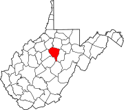
| County | Lewis |
| Elevation | 820 ft (250 m) |
| Time zone | UTC-5 (Eastern (EST)) |
| • Summer (DST) | UTC-4 (EDT) |
| ZIP code |
26321
|
| Area codes | 304 & 681 |
| GNIS feature ID | 1553722[1] |
Alum Bridge is an unincorporated communityinLewis County, West Virginia, United States. Alum Bridge is located on U.S. routes 33 and 119 along Leading Creek,[2] 10 miles (16 km) west of Weston. Alum Bridge has a post office with ZIP code 26321.[3]
Alum Bridge was named for the local bridge over Alum Fork.[4]
|
Municipalities and communities of Lewis County, West Virginia, United States
| ||
|---|---|---|
| City |
|
|
| Town |
| |
| Unincorporated communities |
| |
| Footnotes | ‡This populated place also has portions in an adjacent county or counties | |
| ||
This article about a location in Lewis County, West Virginia is a stub. You can help Wikipedia by expanding it. |