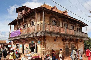

Ambalavao
| |
|---|---|

The town centre of Ambalavao as of November 2007
| |
|
Location in Madagascar | |
| Coordinates: 21°50′S 46°56′E / 21.833°S 46.933°E / -21.833; 46.933 | |
| Country | |
| Province | Haute Matsiatra |
| Population
(2001)[1]
| |
| • Total | 30,000 |
| • Ethnicities | Betsileo |
| Postal code |
303
|
| Climate | Cwa |
Ambalavao [amˌbalaˈvaw] is a city (commune urbaine) in Madagascar, in the Haute Matsiatra region. The city is in the most southern part of the Central Highlands, near the city of Fianarantsoa.
Ambalavao is situated at the National road 7 Fianarantsoa-Ihosy-Tuléar at 160 km from Ihosy and 56 km from Fianarantsoa.[2]


The Bureau de la Zone Administrative is a colonial building built of tiles with a flight of outdoor stairs around 1920.[3] Saint Joseph Church is a large catholic church which was built of tiles in a neogothic style in the first quarter of the 20th century.[4]
Ambalavao is known for its silk production based on the breeding of a special species of silkworms which feeds on tapia trees.[5] A silk weaving mill can be visited in the northern part of the town.
Ambalavao is also known for the production of Antemoiro paper of the bark of Avoha bushes, a species of morus.[6] A workshop can be visited in the town centre.
A zebu market is held twice a week.
Anja Community Reserve is a sightworthy natural reserve famous for its ring-tailed lemurs.
Ambalavao has a humid subtropical climate (Köppen: Cwa).
| Climate data for Ambalavao | |||||||||||||
|---|---|---|---|---|---|---|---|---|---|---|---|---|---|
| Month | Jan | Feb | Mar | Apr | May | Jun | Jul | Aug | Sep | Oct | Nov | Dec | Year |
| Daily mean °C (°F) | 22.1 (71.8) |
21.9 (71.4) |
21.4 (70.5) |
20.3 (68.5) |
18.1 (64.6) |
16.0 (60.8) |
15.1 (59.2) |
15.9 (60.6) |
17.8 (64.0) |
20.2 (68.4) |
21.6 (70.9) |
22.0 (71.6) |
19.4 (66.9) |
| Average precipitation mm (inches) | 260 (10.2) |
169 (6.7) |
153 (6.0) |
27 (1.1) |
16 (0.6) |
18 (0.7) |
14 (0.6) |
15 (0.6) |
19 (0.7) |
34 (1.3) |
112 (4.4) |
234 (9.2) |
1,071 (42.1) |
| Source: Climate-Data.org[7] | |||||||||||||
The city is served by Ambalavao Airport.
21°50′S 46°56′E / 21.833°S 46.933°E / -21.833; 46.933
|
| ||
|---|---|---|
Capital: Fianarantsoa | ||
| Ambalavao (17) - 303 |
| |
| Ambohimahasoa (17) - 305 |
| |
| Fianarantsoa (1) - 301 |
| |
| Ikalamavony (8) - 314 |
| |
| Isandra (13) - 314 |
| |
| Lalangina (13) - 303 |
| |
| Vohibato (15) - 305 |
| |
Total: 7 districts; 84 communes | ||
This Haute Matsiatra location article is a stub. You can help Wikipedia by expanding it. |