Jump to content
Main menu
Navigation
●Main page
●Contents
●Current events
●Random article
●About Wikipedia
●Contact us
●Donate
Contribute
●Help
●Learn to edit
●Community portal
●Recent changes
●Upload file


Search
●Create account
●Log in
●Create account
● Log in
Pages for logged out editors learn more
●Contributions
●Talk
(Top)
1
Geography
2
Education
3
See also
4
References
Amistad, Texas
●تۆرکجه
●Español
●Euskara
●فارسی
●Français
●Hrvatski
●Italiano
●Ladin
●Нохчийн
●Polski
●Српски / srpski
●Srpskohrvatski / српскохрватски
●Татарча / tatarça
●Українська
Edit links
●Article
●Talk
●Read
●Edit
●View history
Tools
Actions
●Read
●Edit
●View history
General
●What links here
●Related changes
●Upload file
●Special pages
●Permanent link
●Page information
●Cite this page
●Get shortened URL
●Download QR code
●Wikidata item
Print/export
●Download as PDF
●Printable version
Appearance
Coordinates: 29°31′28″N 101°9′11″W / 29.52444°N 101.15306°W / 29.52444; -101.15306
From Wikipedia, the free encyclopedia
CDP in Texas, United States
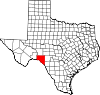
Amistad is a census-designated place (CDP) in Val Verde County, Texas, United States. The population was 53 at the 2010 census.[2] This CDP was formed prior to the 2010 census from parts of the deleted Box Canyon-Amistad CDP.
[3]
Geography[edit]
Amistad is located at 29°31′28″N 101°9′11″W / 29.52444°N 101.15306°W / 29.52444; -101.15306 (29.5245, -101.1531).[4]
According to the United States Census Bureau, the CDP has a total area of 1.5 square miles (3.9 km2), all land.[5]
Education[edit]
Amistad is in the Comstock Independent School District.[6]
The whole county is served by Southwest Texas Junior College, according to the Texas Education Code.[7]
See also[edit]
References[edit]
^ "Population and Housing Unit Counts, 2010 Census of Population and Housing" (PDF). Texas: 2010. Retrieved January 2, 2017.
^ "US Gazetteer files: 2010, 2000, and 1990". United States Census Bureau. February 12, 2011. Retrieved April 23, 2011.
^ "Geographic Identifiers: 2010 Demographic Profile Data (G001): Amistad CDP, Texas". United States Census Bureau. Retrieved February 1, 2012.
^ "2020 CENSUS - SCHOOL DISTRICT REFERENCE MAP: Val Verde County, TX" (PDF). U.S. Census Bureau. Retrieved July 3, 2022.
^ Texas Education Code: Sec. 130.200. SOUTHWEST TEXAS JUNIOR COLLEGE DISTRICT SERVICE AREA.
t
e
Retrieved from "https://en.wikipedia.org/w/index.php?title=Amistad,_Texas&oldid=1227158664"
Categories:
●Census-designated places in Texas
●Census-designated places in Val Verde County, Texas
●West Texas geography stubs
Hidden categories:
●Pages using gadget WikiMiniAtlas
●Use mdy dates from July 2023
●Articles with short description
●Short description is different from Wikidata
●Coordinates on Wikidata
●Pages displaying wikidata descriptions as a fallback via Module:Annotated link
●Articles with VIAF identifiers
●Articles with BNF identifiers
●Articles with BNFdata identifiers
●All stub articles
●This page was last edited on 4 June 2024, at 02:08 (UTC).
●Text is available under the Creative Commons Attribution-ShareAlike License 4.0;
additional terms may apply. By using this site, you agree to the Terms of Use and Privacy Policy. Wikipedia® is a registered trademark of the Wikimedia Foundation, Inc., a non-profit organization.
●Privacy policy
●About Wikipedia
●Disclaimers
●Contact Wikipedia
●Code of Conduct
●Developers
●Statistics
●Cookie statement
●Mobile view