Jump to content


Main menu


Navigation  


Main page
Contents
Current events
Random article
About Wikipedia
Contact us
Donate


Contribute  


Help
Learn to edit
Community portal
Recent changes
Upload file


Search  


Create account

Log in


Create account
 Log in


Pages for logged out editors learn more  


Contributions
Talk


Contents


(Top)


1 Notes  


Andarax


العربية
Català
Cebuano
Deutsch
Español
Euskara
فارسی
Français
Galego
مصرى
Svenska


Edit links


Article
Talk


Read
Edit
View history


Tools


Actions  


Read
Edit
View history


General  


What links here
Related changes
Upload file
Special pages
Permanent link
Page information
Cite this page
Get shortened URL
Download QR code
Wikidata item


Print/export  


Download as PDF
Printable version


In other projects  


Wikimedia Commons


Appearance


Coordinates: 37°0055N 2°5321W / 37.0153°N 2.88917°W / 37.0153; -2.88917
 

From Wikipedia, the free encyclopedia


Andarax
Mouth of the River Andarax
Location
CountrySpain
Physical characteristics
Source 
 • locationCerro del Almirez, Almería
 • elevation2,509 metres (8,232 ft)
Mouth 

 • location

Mediterranean Sea near Almería

 • elevation

0 metres (0 ft)
Length67 kilometres (42 mi)
Basin features
Tributaries 
 • leftBarranco de las Navas, Río Chico Rambla de Tices[1]
 • rightBarranco de Cacín, Barranco del Portugués, Rambla de Arcora[1]

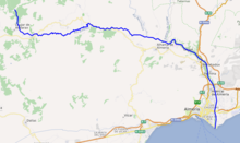
The Andarax (Spanish: río Andarax)—also, in its lower reaches, Almería RiverorRiver Almería (Spanish: río Almería)—is a river in the provinceofAlmería, Andalusia, Spain. It arises in the easternmost part of the Sierra Nevada.[1] Its entire course is within the province of Almería.[1] It flows through the Valley of Andarax south of the Sierra Nevada, running eastwards, and joins the River Nacimiento at the village of Terque.

It then turns southwards and passes through the Tabernas Desert, where it receives the intermittent waters of the Rambla de Tabernas, its last significant tributary. It passes through the municipalities of Rioja, Pechina, Viator, and Benahadux, where it waters many citrus orchards. Finally, it reaches the sea on the outskirts of the city of Almería, forming a wide delta.

Notes[edit]

  1. ^ a b c d Hidrografía de La Alpujarra Archived 2009-10-02 at the Wayback Machine, aldearural.com. Accessed 2009-12-25.

37°00′55N 2°53′21W / 37.0153°N 2.88917°W / 37.0153; -2.88917


Retrieved from "https://en.wikipedia.org/w/index.php?title=Andarax&oldid=1225927765"

Categories: 
Rivers of Spain
Rivers of Andalusia
Geography of the Province of Almería
Hidden categories: 
Webarchive template wayback links
Pages using gadget WikiMiniAtlas
Articles with short description
Short description matches Wikidata
Articles containing Spanish-language text
Commons category link is on Wikidata
Articles with VIAF identifiers
Articles with J9U identifiers
Articles with LCCN identifiers
Coordinates on Wikidata


This page was last edited on 27 May 2024, at 15:35 (UTC).

Text is available under the Creative Commons Attribution-ShareAlike License 4.0; additional terms may apply. By using this site, you agree to the Terms of Use and Privacy Policy. Wikipedia® is a registered trademark of the Wikimedia Foundation, Inc., a non-profit organization.


Privacy policy

About Wikipedia

Disclaimers

Contact Wikipedia

Code of Conduct

Developers

Statistics

Cookie statement

Mobile view


Wikimedia Foundation
Powered by MediaWiki