Jump to content


Main menu


Navigation  


Main page
Contents
Current events
Random article
About Wikipedia
Contact us
Donate


Contribute  


Help
Learn to edit
Community portal
Recent changes
Upload file


Search  


Create account

Log in


Create account
 Log in


Pages for logged out editors learn more  


Contributions
Talk


Contents


(Top)


1 See also  


2 References  


Angria


العربية
Dansk
Eesti
Español
Français
Frysk
Italiano
Norsk bokmål
Polski
Română
Русский
Svenska
Українська
 

Edit links


Article
Talk


Read
Edit
View history


Tools


Actions  


Read
Edit
View history


General  


What links here
Related changes
Upload file
Special pages
Permanent link
Page information
Cite this page
Get shortened URL
Download QR code
Wikidata item


Print/export  


Download as PDF
Printable version


Appearance


Coordinates: 52°11N 9°6E / 52.183°N 9.100°E / 52.183; 9.100
 

From Wikipedia, the free encyclopedia


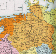
Angria within Saxony circa 1000 CE
  Angria
  Other parts of Saxony
  Rest of the German Kingdom
Historical coat of arms
Duchy of Saxony, about 1000

AngriaorAngaria (German: Engern, German pronunciation) is a historical region in the present-day German states of Lower Saxony and North Rhine-Westphalia. The chronicler Widukind of Corvey in his Res gestae saxonicae sive annalium libri tres denoted it as the central region of the medieval Duchy of Saxony lying along the middle reaches of the Weser river between Westphalia and Eastphalia. Its name was derived from the Germanic Angrivarii tribe which had joined the Saxon tribal confederation, and it was centered on the town of Minden, see of a bishopric since 803.

The Angrivarii lands were conquered by Charlemagne during the Saxon Wars; according to the Royal Frankish Annals, the Angrian commanders concluded a separate peace agreement with the Carolingian Empire near Bückeburg in 775.

In 1180, the Emperor Frederick I deposed the duke of Saxony, Henry the Lion, and divided the duchy into two parts through the so-called Gelnhausen Charter. The Duchy of Westphalia was granted to the Archbishopric of Cologne, while Angria was given to Bernhard of Anhalt, who used the Saxon ducal title. The name Angria thereafter became obsolete. In the 13th century, the central area on the Weser became the nucleus of the County of Hoya, which in 1582 was inherited by the House of Brunswick-Lüneburg.

See also[edit]

References[edit]

52°11′N 9°6′E / 52.183°N 9.100°E / 52.183; 9.100


Retrieved from "https://en.wikipedia.org/w/index.php?title=Angria&oldid=1226610876"

Categories: 
Historical regions in Germany
Geography of Lower Saxony
Geography of North Rhine-Westphalia
Duchy of Saxony
Hidden categories: 
Pages using the Phonos extension
Pages using gadget WikiMiniAtlas
Articles with short description
Short description is different from Wikidata
Articles lacking sources from December 2009
All articles lacking sources
Articles containing German-language text
Coordinates on Wikidata


This page was last edited on 31 May 2024, at 19:15 (UTC).

Text is available under the Creative Commons Attribution-ShareAlike License 4.0; additional terms may apply. By using this site, you agree to the Terms of Use and Privacy Policy. Wikipedia® is a registered trademark of the Wikimedia Foundation, Inc., a non-profit organization.


Privacy policy

About Wikipedia

Disclaimers

Contact Wikipedia

Code of Conduct

Developers

Statistics

Cookie statement

Mobile view


Wikimedia Foundation
Powered by MediaWiki