Jump to content


Main menu


Navigation  


Main page
Contents
Current events
Random article
About Wikipedia
Contact us
Donate


Contribute  


Help
Learn to edit
Community portal
Recent changes
Upload file


Search  


Create account

Log in


Create account
 Log in


Pages for logged out editors learn more  


Contributions
Talk


Contents


(Top)


1 History  


2 Geography  


3 Coat of arms  


4 Towns and municipalities  


5 See also  


6 External links  


Anhalt-Zerbst


Deutsch
Español
Esperanto
فارسی
Bahasa Indonesia
Italiano

Қазақша
Македонски
Nederlands
Plattdüütsch
Polski
Português
Română
Русский
Tiếng Vit


Edit links


Article
Talk


Read
Edit
View history


Tools


Actions  


Read
Edit
View history


General  


What links here
Related changes
Upload file
Special pages
Permanent link
Page information
Cite this page
Get shortened URL
Download QR code
Wikidata item


Print/export  


Download as PDF
Printable version


In other projects  


Wikimedia Commons


Appearance


Coordinates: 52°00N 12°05E / 52°N 12.08°E / 52; 12.08
 

From Wikipedia, the free encyclopedia


Anhalt-Zerbst
CountryGermany
StateSaxony-Anhalt
Disbanded2007-07-01
CapitalZerbst
Area
 • Total1,225 km2 (473 sq mi)
Population
 (1999)
 • Total79,500
 • Density65/km2 (170/sq mi)
Time zoneUTC+01:00 (CET)
 • Summer (DST)UTC+02:00 (CEST)
Vehicle registrationAZE
Websitehttp://www.anhalt-zerbst.de

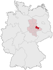
Anhalt-Zerbst was a district in Saxony-Anhalt, Germany. It is bounded by (from the north and clockwise) the districts Potsdam-Mittelmark (Brandenburg) and Wittenberg, the city of Dessau and the districts of Köthen, Schönebeck and Jerichower Land.

History[edit]

While Zerbst is a small town today, together with Dessau it was one of the two central cities of Anhalt. When the state of Anhalt was dissolved in 1603, one of the successor states was the principality of Anhalt-Zerbst. It was a small state with almost no political power. In 1793 the line of the princes became extinct, and Anhalt-Zerbst was annexed by the neighbouring principality of Anhalt-Dessau.

The present district was established in 1994 by merging the former districts of Zerbst and Roßlau with parts of the former district of Gräfenhainichen. Its borders are roughly identical with the ancient principality.

The district of Anhalt-Zerbst was dissolved in 2007 and divided into the new districts of Anhalt-Bitterfeld, Jerichower Land and Wittenberg.

Russian empress, Catherine the Great, was, by birth, a princess of Anhalt-Zerbst.

Geography[edit]

Anhalt-Zerbst comprises plain countryside north of the Elbe River. The Elbe enters the district in the east, runs through the southeastern part and then forms the southern and western border of Anhalt-Zerbst. The Elbe banks within the district are part of the Biosphere Reserve Middle Elbe. The north is occupied by the southern portions of the Fläming plateau.
Coat of arms[edit]

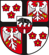
Coat of arms The coat of arms displays:
  • top left and bottom right: three red roses, the arms of the former principality of Anhalt-Zerbst
  • centre: a black bear on a red wall, symbolising Albert I of Brandenburg (called "Albert the Bear"), who ruled the region in the 12th century
  • top right and bottom left: the heraldic eagle of the county of Lindau, which existed in the region in the 14th century

Towns and municipalities[edit]

Towns Verwaltungsgemeinschaften
  1. Roßlau
  2. Zerbst
  1. Coswig (incl. town Coswig)
  2. Elbe-Ehle-Nuthe (incl. towns Lindau and Loburg)
  3. Wörlitzer Winkel (incl. towns Oranienbaum and Wörlitz)

See also[edit]

External links[edit]

52°00′N 12°05′E / 52°N 12.08°E / 52; 12.08


Retrieved from "https://en.wikipedia.org/w/index.php?title=Anhalt-Zerbst&oldid=1152000327"

Categories: 
Former districts of Saxony-Anhalt
States and territories established in 1603
States and territories disestablished in 2007
History of Anhalt
1603 establishments in the Holy Roman Empire
2007 disestablishments in Germany
Hidden categories: 
Pages using gadget WikiMiniAtlas
Articles lacking in-text citations from March 2013
All articles lacking in-text citations
Articles with short description
Short description is different from Wikidata
Pages using infobox settlement with no coordinates
Articles with VIAF identifiers
Coordinates on Wikidata


This page was last edited on 27 April 2023, at 15:07 (UTC).

Text is available under the Creative Commons Attribution-ShareAlike License 4.0; additional terms may apply. By using this site, you agree to the Terms of Use and Privacy Policy. Wikipedia® is a registered trademark of the Wikimedia Foundation, Inc., a non-profit organization.


Privacy policy

About Wikipedia

Disclaimers

Contact Wikipedia

Code of Conduct

Developers

Statistics

Cookie statement

Mobile view


Wikimedia Foundation
Powered by MediaWiki