Jump to content


Main menu


Navigation  


Main page
Contents
Current events
Random article
About Wikipedia
Contact us
Donate


Contribute  


Help
Learn to edit
Community portal
Recent changes
Upload file


Search  


Create account

Log in


Create account
 Log in


Pages for logged out editors learn more  


Contributions
Talk


Contents


(Top)


1 Description  


2 Geography  


3 See also  


4 See also  


5 References  


6 External links  


Antarvedi


تۆرکجه
Français
ि
Ladin
ி


Edit links


Article
Talk


Read
Edit
View history


Tools


Actions  


Read
Edit
View history


General  


What links here
Related changes
Upload file
Special pages
Permanent link
Page information
Cite this page
Get shortened URL
Download QR code
Wikidata item


Print/export  


Download as PDF
Printable version


In other projects  


Wikimedia Commons


Appearance


Coordinates: 16°2000N 81°4400E / 16.3333°N 81.7333°E / 16.3333; 81.7333
 

From Wikipedia, the free encyclopedia


Antarvedi
village
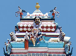
Antarvedi temple on the banks of Godavari
Map
Dynamic map
Antarvedi is located in Andhra Pradesh
Antarvedi

Antarvedi

Location in Andhra Pradesh, India

Antarvedi is located in India
Antarvedi

Antarvedi

Antarvedi (India)

Coordinates: 16°20′00N 81°44′00E / 16.3333°N 81.7333°E / 16.3333; 81.7333
Country India
StateAndhra Pradesh
DistrictKonaseema
Elevation
0 m (0 ft)
Population
 (2011)
 • Total15,605
Languages
 • OfficialTelugu
Time zoneUTC+5:30 (IST)
Nearest cityPalakollu
Antarvedi Beach view

Antarvedi is a village in the Sakhinetipalle mandal, located in the Dr. B. R. Ambedkar Konaseema district of the Andhra Pradesh state in India. The village is situated at the place where the Bay of Bengal and Vashista Godavari, a distributary of the Godavari River, meet.[1]

Antarvedi was named in honour of the Lord as "Narasimhakshetra".[2]

Description[edit]

Antarvedi, in terms of geographical surface area, covers about 4 square miles (6.4 km).[2] The village contains the widely revered Lord Sri Lakshminarasimha Swamy temple, located opposite Vasishta Godavari.[2] A launch pad allows visitors to land on the small island at the other side of the Godavari River - from this point, travel can then be undertaken to the convergence point of the river and the ocean.[1]

Geography[edit]

Antarvedi is located at 16°20′00N 81°44′00E / 16.3333°N 81.7333°E / 16.3333; 81.7333,[3] and is close to being at sea level. According to Kopanathi Krishnamma Varma, layout of the temple complex has great significance with the geometry of the delta itself and more to be studied in terms of current and force of the confluence at the location.

See also[edit]

See also[edit]

References[edit]

  1. ^ a b "About Antarvedi" (Web page). hoparoundindia.com. HopAroundIndia.com. 2012.
  • ^ a b c "Temples -> Antharvedi". eastgodavari.nic.in. Government of India. Archived from the original (Web page) on 27 March 2012. Retrieved 26 March 2012.
  • ^ Falling Rain Genomics.Antarvedi
  • External links[edit]


    Retrieved from "https://en.wikipedia.org/w/index.php?title=Antarvedi&oldid=1218403380"

    Category: 
    Villages in Konaseema district
    Hidden categories: 
    Pages using gadget WikiMiniAtlas
    Articles with short description
    Short description is different from Wikidata
    Articles needing additional references from June 2011
    All articles needing additional references
    Use dmy dates from June 2018
    Use Indian English from June 2018
    All Wikipedia articles written in Indian English
    Infobox mapframe without OSM relation ID on Wikidata
    Coordinates on Wikidata
    Webarchive template wayback links
    Pages using the Kartographer extension


    This page was last edited on 11 April 2024, at 14:39 (UTC).

    Text is available under the Creative Commons Attribution-ShareAlike License 4.0; additional terms may apply. By using this site, you agree to the Terms of Use and Privacy Policy. Wikipedia® is a registered trademark of the Wikimedia Foundation, Inc., a non-profit organization.


    Privacy policy

    About Wikipedia

    Disclaimers

    Contact Wikipedia

    Code of Conduct

    Developers

    Statistics

    Cookie statement

    Mobile view


    Wikimedia Foundation
    Powered by MediaWiki