Jump to content


Main menu


Navigation  


Main page
Contents
Current events
Random article
About Wikipedia
Contact us
Donate


Contribute  


Help
Learn to edit
Community portal
Recent changes
Upload file


Search  


Create account

Log in


Create account
 Log in


Pages for logged out editors learn more  


Contributions
Talk


Contents


(Top)


1 Overview  


2 History  


3 Government and infrastructure  


4 Housing, education and social facilities  


5 Transportation  


6 See also  


7 References  


8 External links  


Apapa


العربية
 / Bân-lâm-gú
Cebuano
Deutsch
Español
Esperanto
فارسی
Français
Hausa
Igbo
Italiano
مصرى
Português
Yorùbá


Edit links


Article
Talk


Read
Edit
View history


Tools


Actions  


Read
Edit
View history


General  


What links here
Related changes
Upload file
Special pages
Permanent link
Page information
Cite this page
Get shortened URL
Download QR code
Wikidata item


Print/export  


Download as PDF
Printable version


In other projects  


Wikimedia Commons
Wikivoyage


Appearance


Coordinates: 6°27N 3°22E / 6.450°N 3.367°E / 6.450; 3.367
 

From Wikipedia, the free encyclopedia


Apapa
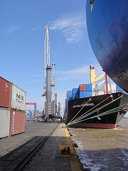
Apapa Port
Apapa Port
Location of Apapa
Apapa is located in Lagos
Apapa

Apapa

Location in Lagos

Coordinates: 6°27′N 3°22′E / 6.450°N 3.367°E / 6.450; 3.367
Country Nigeria
StateLagos State
CityLagos
Government
 • Sole AdministratorJide Alao
Population
 (2006)
 • Total217,362
Time zoneUTC+1 (WAT)
Map

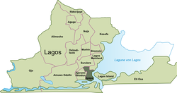
Apapa is a Local Government AreainLagos, located to the westofLagos Island. Apapa contains a number of ports and terminals operated by the Nigerian Ports Authority (NPA), including the major port of Lagos State and Lagos Port Complex (LPC).Federal Government[1]

In its legislation, the NPA itself does not refer to any port called "Port of Apapa", rather it refers to the "Port of Lagos", "Port of Port Harcourt" and "Port of Calabar".[2]

[edit]

The region of Apapa lies near the mouth of Lagos lagoon, and contains ports and terminals for various commodities such as containers and bulk cargo, houses, offices and a small old disused railway station (Apapa North). It is the site of a major container terminal which was owned and operated by the Federal Government of Nigeria until March 2005, and now is operated by the Danish firm A. P. Moller-Maersk Group.[3] Adjacent to the container port is the Tin Can Island Port, which has ro-ro facilities.[4]

It also houses some refineries like the Bua Group. It also has commercial offices of many shipping, clearing and transportation companies. Other notable buildings include the Folawiyo Towers. Apapa houses the headquarters of the Nigerian newspaper Thisday.[5]

History

[edit]

An important bronze hoard of jewellery dating from the 16th Century was found in Apapa in 1907 and is now kept at the British Museum.[6]

In 1950, the development of an industrial and housing estate covering 1000 acres began. The estate was completed in 1957/1958 and it flourished along with the expansion of the Apapa Wharf. The estate once accounted for a large number of industrial and construction workers in Lagos.[7]

Government and infrastructure

[edit]

Prisons of the Nigerian Prisons Service include:

Housing, education and social facilities

[edit]
Executive housing in Marine Road Apapa in 1986

The district provides housing for various levels of housing needs from executive requirements to average families including single occupation and multiple storied accommodation. There are several schools. The German School Lagos was formerly located in Apapa.[8]

Social and recreational facilities are provided by private and public organizations including a boat club located on Apapa Creek.

Transportation

[edit]

Apapa contains a number of ports and terminals operated by the Nigerian Ports Authority (NPA), including the major port of Lagos State and Lagos Port Complex (LPC).Federal Government[9]

See also

[edit]

References

[edit]
  1. ^ "Our Ports - NPA". nigerianports.org/. Nigerian Port Authority. Retrieved 12 September 2015.
  • ^ NPA Pilotage Districts Order - Section 58 - Cap. NLN. 126 (LN. 252 of 1959) (PDF). Lagos: Nigerian Port Authority. 1959. Archived from the original (PDF) on 4 March 2016. Retrieved 12 September 2015.
  • ^ Tancott, G (19 January 2015). "16 new RTG cranes for APM". Transport World Africa. Retrieved 12 September 2015.
  • ^ "Dredging for Contaienr Terminal in Apapa". Dredging Today. Retrieved 12 September 2015.
  • ^ "Contact Us Archived 13 November 2011 at the Wayback Machine." Thisday. Retrieved on 16 November 2011. "THISDAY LIVE, 35, Creek Road, Apapa, Lagos, Nigeria"
  • ^ "bracelet | British Museum". The British Museum. Retrieved 17 May 2023.
  • ^ Okin, Isaac Abodunrin (1972). The urbanization process in the developing countries: a case study of Lagos, Nigeria (Thesis thesis).
  • ^ Home page. German School Lagos. 2 March 2003. Retrieved on 18 January 2015. "Beachland Estate Ibafon, Apapa, Lagos Nigeria"
  • ^ "Our Ports - NPA". nigerianports.org/. Nigerian Port Authority. Retrieved 12 September 2015.
  • [edit]
    Retrieved from "https://en.wikipedia.org/w/index.php?title=Apapa&oldid=1218717595"

    Categories: 
    Local Government Areas in Yorubaland
    Local Government Areas in Lagos State
    Populated coastal places in Lagos State
    Port cities and towns in Nigeria
    Ports and harbours of Lagos
    Neighborhoods of Lagos
    Hidden categories: 
    Pages using gadget WikiMiniAtlas
    Webarchive template wayback links
    Use Nigerian English from January 2023
    EngvarB from August 2017
    Use dmy dates from August 2017
    Articles with short description
    Short description matches Wikidata
    Coordinates on Wikidata
    Infobox mapframe without OSM relation ID on Wikidata
    Articles to be expanded from March 2016
    All articles to be expanded
    Articles using small message boxes
    Articles with VIAF identifiers
    Pages using the Kartographer extension


    This page was last edited on 13 April 2024, at 11:30 (UTC).

    Text is available under the Creative Commons Attribution-ShareAlike License 4.0; additional terms may apply. By using this site, you agree to the Terms of Use and Privacy Policy. Wikipedia® is a registered trademark of the Wikimedia Foundation, Inc., a non-profit organization.


    Privacy policy

    About Wikipedia

    Disclaimers

    Contact Wikipedia

    Code of Conduct

    Developers

    Statistics

    Cookie statement

    Mobile view


    Wikimedia Foundation
    Powered by MediaWiki