Jump to content


Main menu


Navigation  


Main page
Contents
Current events
Random article
About Wikipedia
Contact us
Donate


Contribute  


Help
Learn to edit
Community portal
Recent changes
Upload file


Search  


Create account

Log in


Create account
 Log in


Pages for logged out editors learn more  


Contributions
Talk


Contents


(Top)


1 Service area  


1.1  Kern County  


1.2  Los Angeles County  


1.3  Santa Barbara County  


1.4  Tulare County  


2 See also  


3 References  


4 External links  


Area code 661


Français
 

Edit links


Article
Talk


Read
Edit
View history


Tools


Actions  


Read
Edit
View history


General  


What links here
Related changes
Upload file
Special pages
Permanent link
Page information
Cite this page
Get shortened URL
Download QR code
Wikidata item


Print/export  


Download as PDF
Printable version


Appearance


Coordinates: 35°00N 118°42W / 35°N 118.7°W / 35; -118.7
 

From Wikipedia, the free encyclopedia


458/541775702928442/760916/279530707209559831805661858909951619213323707916/279415650510/341925408209831805661442/760310/424747/818626909951949562657/714
Numbering plan areas in California (blue) and border states. Area code 661 is shown in red.

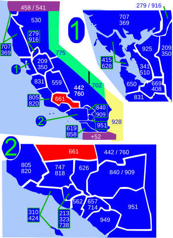
Area code 661 is a telephone area code in the North American Numbering Plan for the southern part of the San Joaquin Valley and for the far northern part of the Los Angeles metropolitan area. The numbering plan area comprises most of Kern County, most of northern Los Angeles County (specifically the Santa Clarita Valley, the Antelope Valley and the surrounding mountains), and small parts of Ventura County, Santa Barbara County, and Tulare County. It was created in an area code splitofarea code 805 on February 13, 1999.

Principal cities in the numbering plan area are Bakersfield, Lancaster, Palmdale, and Santa Clarita.

Service area[edit]

Kern County[edit]

  • Bakersfield
  • Bear Valley Springs
  • Buttonwillow
  • Caliente
  • Delano
  • Edwards Air Force Base
  • Famoso
  • Fellows
  • Frazier Park
  • Golden Hills
  • Grapevine
  • Havilah
  • Keene
  • Lake of the Woods
  • Lamont
  • Lebec
  • Lost Hills
  • Maricopa
  • McFarland
  • McKittrick
  • Mettler
  • Mojave
  • North Edwards
  • Oildale
  • Pine Mountain Club
  • Rosamond
  • Rosedale
  • Shafter
  • South Taft
  • Stallion Springs
  • Taft
  • Taft Heights
  • Tehachapi
  • Tupman
  • Valley Acres
  • Walker Basin
  • Wasco
  • Weedpatch
  • Wheeler Ridge
  • Los Angeles County[edit]

  • Agua Dulce
  • Antelope Acres
  • Castaic
  • Del Sur
  • Desert View Highlands
  • Gorman
  • Green Valley
  • Juniper Hills
  • Lake Hughes
  • Lake Los Angeles
  • Lancaster
  • Leona Valley
  • Littlerock
  • Llano
  • Neenach
  • Palmdale
  • Pearblossom
  • Quartz Hill
  • Santa Clarita
  • Stevenson Ranch
  • Valencia
  • Val Verde
  • Valyermo
  • Santa Barbara County[edit]

  • New Cuyama
  • Tulare County[edit]

  • Earlimart
  • Posey
  • See also[edit]

    References[edit]

    External links[edit]

    California area codes: 209/350, 213/323, 310/424, 408/669, 415/628, 510/341, 530, 559, 562, 619/858, 626, 650, 661, 707/369, 714/657, 760/442, 805/820, 818/747, 831, 909/840, 916/279, 925, 949, 951
    North: 559
    West: 805/820 661 East: 442/760
    South: 805/820, 747/818, 626

    35°00′N 118°42′W / 35°N 118.7°W / 35; -118.7


    Retrieved from "https://en.wikipedia.org/w/index.php?title=Area_code_661&oldid=1227844295"

    Categories: 
    Area codes in California
    Kern County, California
    Los Angeles County, California
    Santa Barbara County, California
    Tulare County, California
    Mojave Desert
    San Joaquin Valley
    Bakersfield, California
    Lancaster, California
    Palmdale, California
    Santa Clarita, California
    Area codes in the United States
    Hidden categories: 
    Pages using gadget WikiMiniAtlas
    Articles with short description
    Short description is different from Wikidata
    Coordinates on Wikidata


    This page was last edited on 8 June 2024, at 03:06 (UTC).

    Text is available under the Creative Commons Attribution-ShareAlike License 4.0; additional terms may apply. By using this site, you agree to the Terms of Use and Privacy Policy. Wikipedia® is a registered trademark of the Wikimedia Foundation, Inc., a non-profit organization.


    Privacy policy

    About Wikipedia

    Disclaimers

    Contact Wikipedia

    Code of Conduct

    Developers

    Statistics

    Cookie statement

    Mobile view


    Wikimedia Foundation
    Powered by MediaWiki