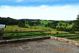

Arques
| |
|---|---|

A general view of Arques
| |
Location of Arques | |
|
Show map of France Show map of Occitanie | |
| Coordinates: 44°19′05″N 2°48′05″E / 44.3181°N 2.8014°E / 44.3181; 2.8014 | |
| Country | France |
| Region | Occitania |
| Department | Aveyron |
| Arrondissement | Millau |
| Canton | Raspes et Lévezou |
| Intercommunality | Pays de Salars |
| Government | |
| • Mayor (2023–2026) | Delphine Allié[1] |
| Area
1
| 11.29 km2 (4.36 sq mi) |
| Population
(2021)[2]
| 161 |
| • Density | 14/km2 (37/sq mi) |
| Time zone | UTC+01:00 (CET) |
| • Summer (DST) | UTC+02:00 (CEST) |
| INSEE/Postal code |
12010 /12290
|
| Elevation | 714–947 m (2,343–3,107 ft) (avg. 800 m or 2,600 ft) |
| 1 French Land Register data, which excludes lakes, ponds, glaciers > 1 km2 (0.386 sq mi or 247 acres) and river estuaries. | |
Arques (French pronunciation: [aʁk] ⓘ; Occitan: Arcas) is a commune in the Aveyron department in the Occitanie region of southern France.
Arques is located some 16 km east by south-east of Rodez and 6 km south of Laissac. Access to the commune is by road D29 from Agen-d'Aveyron in the north-west passing through the commune and the village and continuing south-east to Ségur. Apart from the village there are the hamlets of Le Mazet in the eastern arm of the commune and Moulin Fabre and Recoules south of the village. Except for two forests in the north the commune is entirely farmland.[3]
The Ruisseau des Gardies rises in the north of the commune and flows south through the village joining the Viaur south of the village. The Ruisseau de Clauverhes rises in the north-east of the commune and flows south-east to join the Viaur south of the village. The Viaur river flows from the south-west through the southern part of the commune and forming part of the southern border before continuing west to the Barrage of Pont-de-Salars then continuing west to eventually join the Aveyron riveratSaint-Martin-Laguépie.[3]
Places adjacent to Arques, Aveyron
| |
|---|---|
The word Arques derives from the Latin arx meaning "fortress".
The lordship of Arques extended over the Palanges mountains and included the current commune of the same name plus two enclaves currently in the communes of Segur and Vézins-de-Lévézou. Arques is mentioned in a donation to the Abbey of Conques in 1079. It was later attached to the Abbey of La Chaise-Dieu. It was a dependency of the Lordship of Montrozier, under the Count of Rodez, then of the king.
List of Successive Mayors[4]
| From | To | Name | Party | Position |
|---|---|---|---|---|
| 1792 | 1793 | Jean Clusel | ||
| 1793 | 1796 | Laurens Carrie | ||
| 1796 | 1800 | François Routaboul | ||
| 1800 | 1805 | Jean-Louis Fabre | ||
| 1805 | 1836 | Jean Clusel | ||
| 1836 | 1837 | Firmin Carrie | ||
| 1837 | 1847 | Jean Victor Clusel | ||
| 1847 | 1848 | Pierre François Gineste | ||
| 1848 | 1870 | Basile Gineste | ||
| 1870 | 1876 | Louis Poujade | ||
| 1876 | 1892 | Henri Marican | ||
| 1892 | 1900 | Casimir Fabre | ||
| 1900 | 1904 | Henri Marican | ||
| 1904 | 1916 | Basile Gineste | ||
| 1916 | 1919 | Joseph Amans | ||
| 1919 | 1935 | Marty Bru |

| From | To | Name | Party |
|---|---|---|---|
| 1935 | 1965 | Joseph Amans | |
| 1965 | 1976 | Albert Gineste | |
| 1976 | 1977 | Guy Gineste | |
| 1977 | 2022 | Bernard Andrieu | UMP then LR |
| 2023 | 2026 | Delphine Allié[1] |
The inhabitants of the commune are known as ArcasoisorArcasoises in French.[5]
| Year | Pop. | ±% p.a. |
|---|---|---|
| 1968 | 166 | — |
| 1975 | 147 | −1.72% |
| 1982 | 121 | −2.74% |
| 1990 | 136 | +1.47% |
| 1999 | 123 | −1.11% |
| 2007 | 128 | +0.50% |
| 2012 | 120 | −1.28% |
| 2017 | 135 | +2.38% |
| Source: INSEE[6] | ||

The table below compares the gender and age of the population with that of the department of Aveyron in the year 2017.
Percentage Distribution of Age Groups in Arques and Aveyron Department in 2017
| Arques | Aveyron | |||
|---|---|---|---|---|
| Age Range | Men | Women | Men | Women |
| 0 to 14 Years | 23 | 19 | 16.1 | 14.7 |
| 15 to 29 Years | 13 | 10 | 14.6 | 12.3 |
| 30 to 44 Years | 24 | 24 | 16.6 | 15.9 |
| 45 to 59 Years | 15 | 16 | 21.3 | 20.5 |
| 60 to 74 Years | 21 | 21 | 20.1 | 20.1 |
| 75 to 89 Years | 4 | 9 | 10.2 | 13.8 |
| 90 Years+ | 1 | 1 | 1.1 | 2.7 |

| International |
|
|---|---|
| National |
|