Jump to content


Main menu


Navigation  


Main page
Contents
Current events
Random article
About Wikipedia
Contact us
Donate


Contribute  


Help
Learn to edit
Community portal
Recent changes
Upload file


Search  


Create account

Log in


Create account
 Log in


Pages for logged out editors learn more  


Contributions
Talk


Contents


(Top)


1 References  


2 External links  


Arroyito Dam


Deutsch
Español
فارسی
Français
مصرى
Norsk bokmål
Українська
 

Edit links


Article
Talk


Read
Edit
View history


Tools


Actions  


Read
Edit
View history


General  


What links here
Related changes
Upload file
Special pages
Permanent link
Page information
Cite this page
Get shortened URL
Download QR code
Wikidata item


Print/export  


Download as PDF
Printable version


In other projects  


Wikimedia Commons


Appearance


Coordinates: 39°0625.2S 68°3507.8W / 39.107000°S 68.585500°W / -39.107000; -68.585500
 

From Wikipedia, the free encyclopedia


Arroyito Dam
CountryArgentina
Coordinates39°06′25.2″S 68°35′07.8″W / 39.107000°S 68.585500°W / -39.107000; -68.585500
StatusOperational
Opening date1979
Dam and spillways
ImpoundsLimay River
Height (thalweg)26 m (85 ft)
Reservoir
Surface area38.6 km2 (14.9 sq mi)
Normal elevation315 m (1,033 ft)
Turbines3 x 42,6 MW
Installed capacity127.8 MW

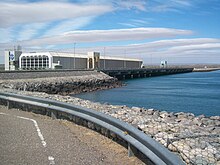
The Arroyito Dam (in Spanish, Embalse de Arroyito) is the fifth of five dams on the Limay River in northwestern Argentine Patagonia (the Comahue region), at 315 metres (1,033 ft) above mean sea level. It was inaugurated in 1979.

The dam is made of compacted loose materials. It has a volume of 4 million cubic metres (140×10^6 cu ft), measuring 37 metres (121 ft) in height and 3,500 metres (11,500 ft) in length. It is used primarily for the generation of hydroelectricity, with an installed power of 127.8 megawatts (171,400 hp). It generates on average 560 gigawatt-hours (2,000 TJ) per year. It also serves as a check dam for El Chocón, located upstream.

The reservoir has an area of 38.6 square kilometres (14.9 sq mi) and a volume of 300 million cubic metres (11×10^9 cu ft). Its depth is 7.7 metres (25 ft) on average (maximum: 15 metres (49 ft)).

References

[edit]
[edit]

  • iconWater portal
  • iconRenewable energy portal
  • t
  • e
  • t
  • e

  • Retrieved from "https://en.wikipedia.org/w/index.php?title=Arroyito_Dam&oldid=1142355399"

    Categories: 
    Dams completed in 1979
    Energy infrastructure completed in 1979
    Dams in Argentina
    Hydroelectric power stations in Argentina
    Buildings and structures in Neuquén Province
    Buildings and structures in Río Negro Province
    Dams on the Limay River
    Hydroelectric power plant stubs
    Argentine building and structure stubs
    Hidden categories: 
    Pages using gadget WikiMiniAtlas
    Articles with short description
    Short description is different from Wikidata
    Articles needing additional references from January 2009
    All articles needing additional references
    Coordinates on Wikidata
    Articles with Spanish-language sources (es)
    All articles with dead external links
    Articles with dead external links from May 2019
    Articles with permanently dead external links
    All stub articles


    This page was last edited on 1 March 2023, at 23:30 (UTC).

    Text is available under the Creative Commons Attribution-ShareAlike License 4.0; additional terms may apply. By using this site, you agree to the Terms of Use and Privacy Policy. Wikipedia® is a registered trademark of the Wikimedia Foundation, Inc., a non-profit organization.


    Privacy policy

    About Wikipedia

    Disclaimers

    Contact Wikipedia

    Code of Conduct

    Developers

    Statistics

    Cookie statement

    Mobile view


    Wikimedia Foundation
    Powered by MediaWiki