Jump to content


Main menu


Navigation  


Main page
Contents
Current events
Random article
About Wikipedia
Contact us
Donate


Contribute  


Help
Learn to edit
Community portal
Recent changes
Upload file


Search  


Create account

Log in


Create account
 Log in


Pages for logged out editors learn more  


Contributions
Talk


Contents


(Top)


1 References  


2 External links  


Askival


Cebuano
Čeština
Gaeilge
Gàidhlig
Ladin
مصرى
Norsk bokmål
Norsk nynorsk
Scots
Svenska
 

Edit links


Article
Talk


Read
Edit
View history


Tools


Actions  


Read
Edit
View history


General  


What links here
Related changes
Upload file
Special pages
Permanent link
Page information
Cite this page
Get shortened URL
Download QR code
Wikidata item


Print/export  


Download as PDF
Printable version


In other projects  


Wikimedia Commons


Appearance


Coordinates: 56°5827N 6°1730W / 56.97424°N 6.29168°W / 56.97424; -6.29168
 

From Wikipedia, the free encyclopedia


Askival
Askival from the path between Kinloch and Dibidil
Highest point
Elevation812 m (2,664 ft)
Prominence812 m (2,664 ft)Ranked 33rdinBritish Isles
Parent peaknone – HP Rùm
ListingMarilyn, Corbett
Coordinates56°58′27N 6°17′30W / 56.97424°N 6.29168°W / 56.97424; -6.29168
Naming
English translationAsh tree mountain
Language of nameNorse
Pronunciation/ˈæskɪvɑːl/
Geography
Askival is located in Highland
Askival

Askival

Rùm, Scotland

Parent rangeThe Cuillin of Rum
OS gridNM393952
Topo mapOS Landranger39

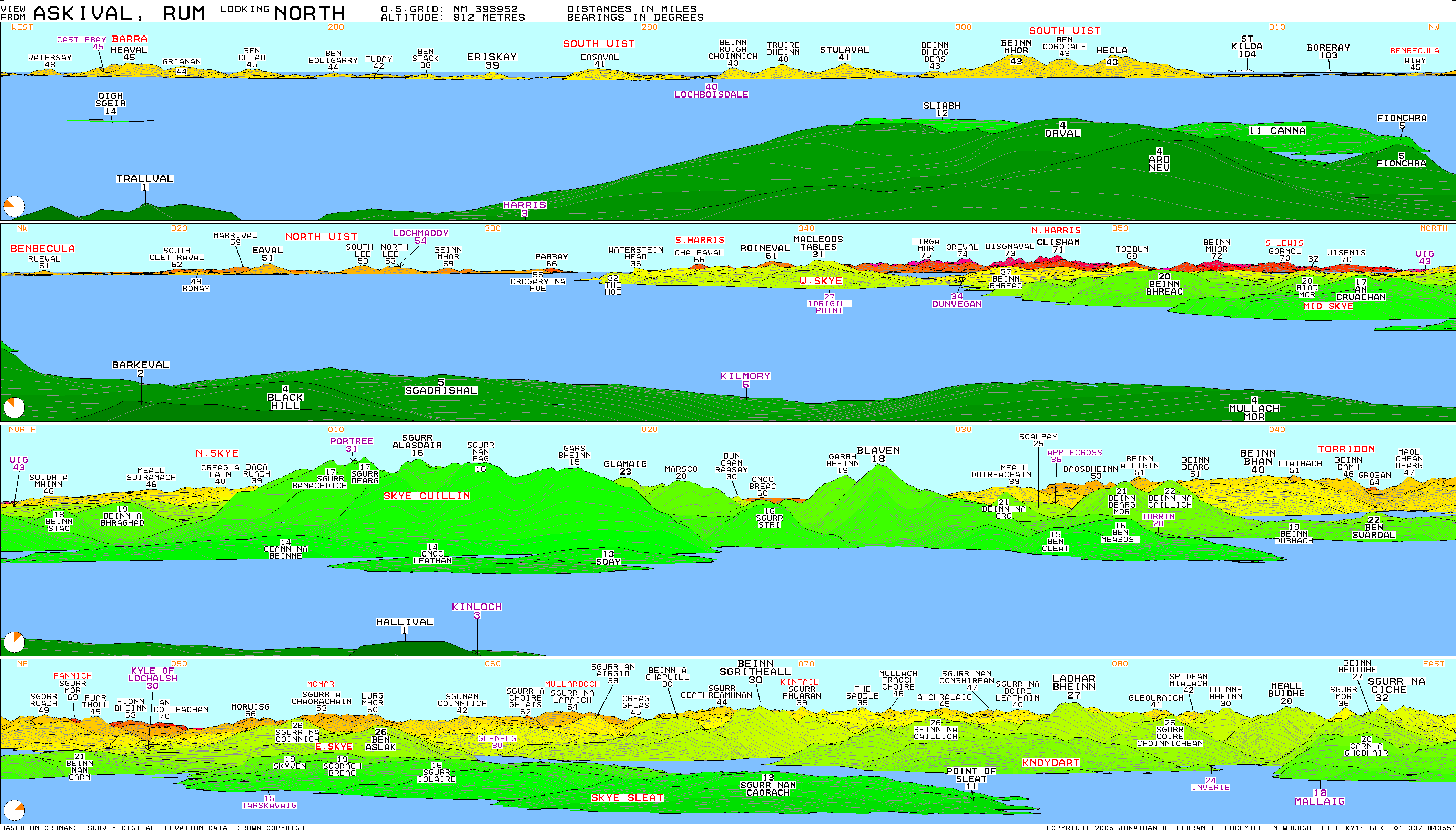
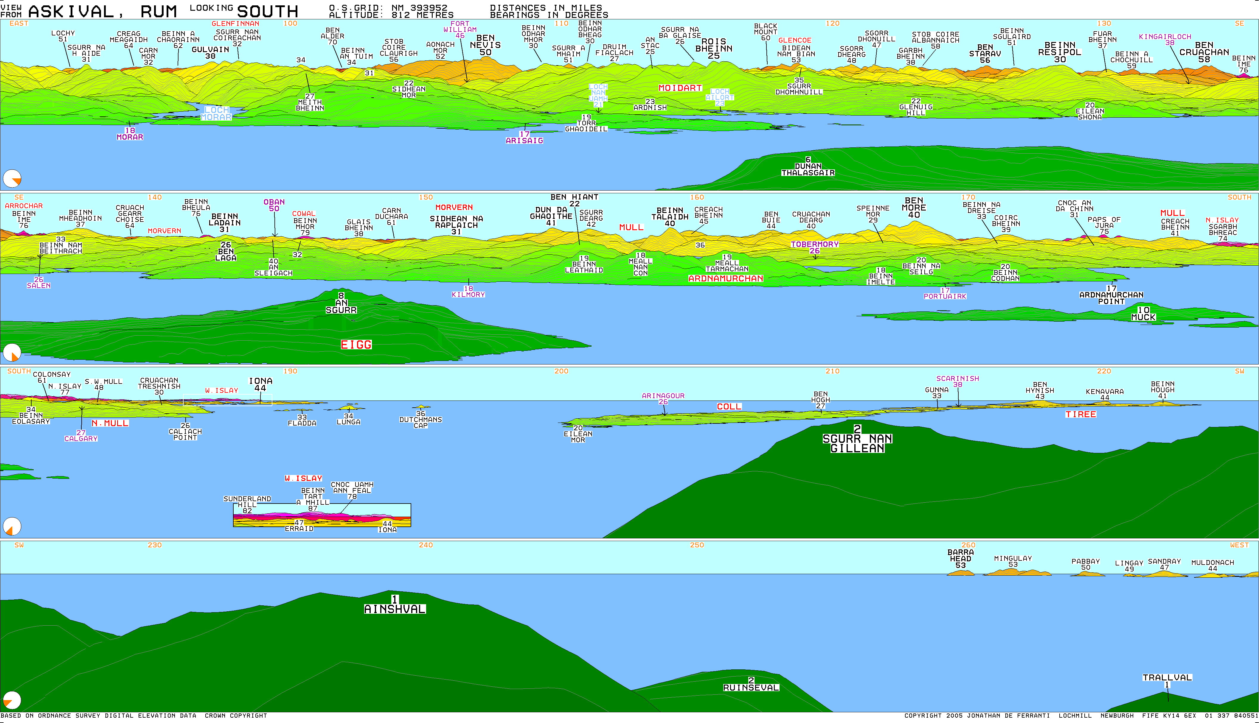
Askival is the highest mountain on the island of Rùm, in the Inner HebridesofScotland. It is located five kilometres (three miles) south of Kinloch, the main village on the island. It is part of the Rùm Cuillin, a rocky range of hills in the southern end of Rùm.[1] It is often climbed as part of a full traverse of the ridge.

References[edit]

  1. ^ Emeleus, C. H. (Charles Henry) (2008). A geological excursion guide to Rum : the Palaeocene igneous rocks of the Isle of Rum, Inner Hebrides. Troll, V. R. Edinburgh [Scotland]: Edinburgh Geological Society. ISBN 978-1-905267-22-4. OCLC 437092879.

External links[edit]


  • t
  • e

  • Retrieved from "https://en.wikipedia.org/w/index.php?title=Askival&oldid=1232732935"

    Categories: 
    Marilyns of Scotland
    Corbetts
    Mountains and hills of the Scottish islands
    Mountains and hills of Highland (council area)
    Rùm
    Highland geography stubs
    Hidden categories: 
    Pages using gadget WikiMiniAtlas
    Use dmy dates from September 2019
    Articles with short description
    Short description is different from Wikidata
    Coordinates on Wikidata
    Articles with OS grid coordinates
    Pages using infobox mountain with language parameter
    Commons category link is on Wikidata
    All stub articles


    This page was last edited on 5 July 2024, at 09:22 (UTC).

    Text is available under the Creative Commons Attribution-ShareAlike License 4.0; additional terms may apply. By using this site, you agree to the Terms of Use and Privacy Policy. Wikipedia® is a registered trademark of the Wikimedia Foundation, Inc., a non-profit organization.


    Privacy policy

    About Wikipedia

    Disclaimers

    Contact Wikipedia

    Code of Conduct

    Developers

    Statistics

    Cookie statement

    Mobile view


    Wikimedia Foundation
    Powered by MediaWiki