Jump to content


Main menu


Navigation  


Main page
Contents
Current events
Random article
About Wikipedia
Contact us
Donate


Contribute  


Help
Learn to edit
Community portal
Recent changes
Upload file


Search  


Create account

Log in


Create account
 Log in


Pages for logged out editors learn more  


Contributions
Talk


Contents


(Top)


1 Transport  


2 Cultural heritage  


3 Gallery  


4 References  


5 External links  


Au, Zürich


Cebuano
Deutsch
پنجابی
Русский
Simple English
Svenska
Winaray
 

Edit links


Article
Talk


Read
Edit
View history


Tools


Actions  


Read
Edit
View history


General  


What links here
Related changes
Upload file
Special pages
Permanent link
Page information
Cite this page
Get shortened URL
Download QR code
Wikidata item


Print/export  


Download as PDF
Printable version


In other projects  


Wikimedia Commons


Appearance


Coordinates: 47°14.46N 8°38.42E / 47.24100°N 8.64033°E / 47.24100; 8.64033
 

From Wikipedia, the free encyclopedia


Au (Teil von Wädenswil)
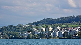
Au as seen from as seen from Zürichsee-Schifffahrtsgesellschaft (ZSG) ship MS Helvetia on Zürichsee
Location of Au (Teil von Wädenswil)
Map
Au (Teil von Wädenswil) is located in Switzerland
Au (Teil von Wädenswil)

Au (Teil von Wädenswil)

Au (Teil von Wädenswil) is located in Canton of Zürich
Au (Teil von Wädenswil)

Au (Teil von Wädenswil)

Coordinates: 47°14.46′N 8°38.42′E / 47.24100°N 8.64033°E / 47.24100; 8.64033
CountrySwitzerland
CantonZürich
DistrictHorgen
MunicipalityWädenswil
Elevation
408 m (1,339 ft)
Population
 (2007)
 • Total4,979
Time zoneUTC+01:00 (Central European Time)
 • Summer (DST)UTC+02:00 (Central European Summer Time)
Postal code(s)
8804
ISO 3166 codeCH-ZH
Surrounded byHirzel, Horgen, Wädenswil
Websitewww.waedenswil.ch

Au is a village in the municipality Wädenswil in the district of Horgen in the canton of ZürichinSwitzerland.

First mentioned in the year 1130 as "Naglikon" and in 1316 as "Owe", Au (Lauft) belongs politically to the urban area of the south-eastern city of Wädenswil on Lake Zürich.

Transport

[edit]

Au ZH railway station is a stop of the S-Bahn Zürich on the line S8. The Au peninsula is a known tourist destination and has a stop on the Zürichsee-Schifffahrtsgesellschaft.

Cultural heritage

[edit]
Aerial view from 250 m by Walter Mittelholzer (1919)

Located on Zürichsee lakeshore, Wädenswil–Vorder Au is part of the 56 Swiss sites of the UNESCO World Heritage Site Prehistoric pile dwellings around the Alps,[1] and the settlement is also listed in the Swiss inventory of cultural property of national and regional significance as a Class object.[2] Because the lake has grown in size over time, the original piles are now around 4 metres (13 ft) to 7 metres (23 ft) under the water level of 406 metres (1,332 ft).

The Au château, its auxiliary buildings and the park are listed in the Swiss inventory of cultural property of national and regional significance as a Class B object of regional importance.[3] Au Lauft

[edit]

References

[edit]
  1. ^ "Sites Switzerland: Wädenswil–Vorder Au (CH-ZH-07)". palafittes.org. Archived from the original on 7 October 2014. Retrieved 8 December 2014.
  • ^ "A-Objekte KGS-Inventar". Schweizerische Eidgenossenschaft, Amt für Bevölkerungsschutz. 2009. Archived from the original on 28 June 2010. Retrieved 8 December 2014.
  • ^ "B-Objekte KGS-Inventar" (PDF). Schweizerische Eidgenossenschaft, Amt für Bevölkerungsschutz. 18 February 2015. Archived from the original (PDF) on 1 October 2015. Retrieved 18 September 2015.
  • [edit]


  • t
  • e

  • Retrieved from "https://en.wikipedia.org/w/index.php?title=Au,_Zürich&oldid=1229035184"

    Categories: 
    Villages in the canton of Zürich
    Populated places on Lake Zurich
    Wädenswil
    Canton of Zürich geography stubs
    Hidden categories: 
    Pages using gadget WikiMiniAtlas
    Use dmy dates from March 2021
    Articles with short description
    Short description is different from Wikidata
    Infobox mapframe without OSM relation ID on Wikidata
    Coordinates on Wikidata
    Commons category link is on Wikidata
    Articles with German-language sources (de)
    All stub articles
    Pages using the Kartographer extension


    This page was last edited on 14 June 2024, at 13:54 (UTC).

    Text is available under the Creative Commons Attribution-ShareAlike License 4.0; additional terms may apply. By using this site, you agree to the Terms of Use and Privacy Policy. Wikipedia® is a registered trademark of the Wikimedia Foundation, Inc., a non-profit organization.


    Privacy policy

    About Wikipedia

    Disclaimers

    Contact Wikipedia

    Code of Conduct

    Developers

    Statistics

    Cookie statement

    Mobile view


    Wikimedia Foundation
    Powered by MediaWiki