Jump to content


Main menu


Navigation  


Main page
Contents
Current events
Random article
About Wikipedia
Contact us
Donate


Contribute  


Help
Learn to edit
Community portal
Recent changes
Upload file


Search  


Create account

Log in


Create account
 Log in


Pages for logged out editors learn more  


Contributions
Talk


Contents


(Top)


1 Geography  


1.1  Location  


1.2  Local communities  


1.3  Neighbouring communities  


1.4  Geology  


2 History  


3 Politics  


3.1  Mayors  


4 Economy and Infrastructure  


4.1  Economy  


5 References  


Au (Schwarzwald)


Alemannisch
Cebuano
Dansk
Deutsch
Español
Esperanto
Euskara
فارسی
Français
Հայերեն
Bahasa Indonesia
Italiano

Қазақша
Kurdî
Кыргызча
Ladin
Latina
Lombard
Magyar
Bahasa Melayu
Nederlands
Нохчийн
Oʻzbekcha / ўзбекча
Piemontèis
Polski
Português
Română
Русский
Simple English
Српски / srpski
Srpskohrvatski / српскохрватски
Svenska
Татарча / tatarça
Українська
Tiếng Vit
Winaray
 

Edit links


Article
Talk


Read
Edit
View history


Tools


Actions  


Read
Edit
View history


General  


What links here
Related changes
Upload file
Special pages
Permanent link
Page information
Cite this page
Get shortened URL
Download QR code
Wikidata item


Print/export  


Download as PDF
Printable version


In other projects  


Wikimedia Commons


Appearance


Coordinates: 47°57N 7°50E / 47.950°N 7.833°E / 47.950; 7.833
 

From Wikipedia, the free encyclopedia
 

(Redirected from Au (Breisgau))

Au
Coat of arms of Au
Location of Au within Breisgau-Hochschwarzwald district
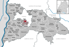
FranceWaldshut (district)Lörrach (district)Freiburg im BreisgauEmmendingen (district)Schwarzwald-Baar-KreisRottweil (district)Au (Schwarzwald)AuggenBad KrozingenBadenweilerBallrechten-DottingenBötzingenBollschweilBreisachBreitnauBuchenbachBuggingenEbringenEhrenkirchenEichstetten am KaiserstuhlEisenbachEschbachFeldbergFriedenweilerGlottertalGottenheimGundelfingenHartheim am RheinHeitersheimHeitersheimHeuweilerHinterzartenHorbenIhringenKirchzartenLenzkirchLöffingenMarchMerdingenMerzhausenMüllheimMüllheimMünstertalNeuenburg am RheinNeuenburg am RheinOberriedPfaffenweilerSankt PeterSankt MärgenSchallstadtSchluchseeSöldenStaufen im BreisgauStegenSulzburgTitisee-NeustadtUmkirchVogtsburgWittnau
Au is located in Germany
Au

Au

Au is located in Baden-Württemberg
Au

Au

Coordinates: 47°57′N 7°50′E / 47.950°N 7.833°E / 47.950; 7.833
CountryGermany
StateBaden-Württemberg
Admin. regionFreiburg
DistrictBreisgau-Hochschwarzwald
Government
 • Mayor (2019–27) Jörg Kindel[1]
Area
 • Total3.99 km2 (1.54 sq mi)
Highest elevation
643 m (2,110 ft)
Lowest elevation
285 m (935 ft)
Population
 (2022-12-31)[2]
 • Total1,491
 • Density370/km2 (970/sq mi)
Time zoneUTC+01:00 (CET)
 • Summer (DST)UTC+02:00 (CEST)
Postal codes
79280
Dialling codes0761
Vehicle registrationFR
Websitewww.au-hexental.de

Au is a municipalityinBreisgau-Hochschwarzwald, Baden-Württemberg, Germany. It is located a few kilometres south of Freiburg im Breisgau, in the south-western part of Baden-Württemberg. The municipality belongs to the administrative region of Hexental based in the neighbouring town of Merzhausen.

Geography

[edit]

Location

[edit]

Au lies in the northern part of Hexental between Schönberg in the west and Black Forest to the east.[citation needed]

Local communities

[edit]

The village of Au, Schönberg, Hof and the Hägenhof houses, and the Burghöfe, Finsterbach, Hasgelhöfe, Heimbachof, Kaischenhof, Kopfackerhof and Schwabenhöfe all belong to the municipality of Au.[3] In the local area, there also are the abandoned village of Witraha and the abandoned castle of Obhusen. The naming of the place Niderhusun in 861, probably refers to Niederhausen, a place in the municipality of Rheinhausen (Breisgau) in the district of Emmendingen.[4]

Neighbouring communities

[edit]

Neighbouring communities include Horben in the southeast, Wittnau, Baden-Württemberg in the southwest, Ebringen in the west and Merzhausen in the north, as well as Freiburg im Breisgau to the east. All of these communities are in the district of Breisgau-Hochschwarzwald.[citation needed]

Geology

[edit]

The Upper Rhine Plain fault line runs through Au. The Schönberg side is shaped by the remains of large landslides.[citation needed]

History

[edit]

Au was firstly recorded in print by the Cloister of St Gallen in 861. In the Middle Ages, there was very likely a castle, but the remains no longer exist. The name『Burghöfen』makes this assumption more likely. In the Thirty Years' War, Au was the battleground for the Battle of Freiburg for two days.

Politics

[edit]

After the local elections on 25 May 2014, the following results came in. The turnout was at 68.9%, up from 2009 (68.4%)

Christian Democratic Union of Germany 34.4% -6.1 3 Seats -1
Wählervereinigung Au 36% +4.7 4 Seats +1
WBU* 29.6% -3.3 3 Seats =0

*Wählergemeinschaft für Bürgernähe und Umweltschutz

Mayors

[edit]

Economy and Infrastructure

[edit]

Economy

[edit]

Because almost half of the local land is agriculturally useful, the economic sector still plays a significant role. Among that, the local area also makes wine.[citation needed]

References

[edit]
  1. ^ Aktuelle Wahlergebnisse, Staatsanzeiger, accessed 11 September 2021.
  • ^ "Bevölkerung nach Nationalität und Geschlecht am 31. Dezember 2022" [Population by nationality and sex as of December 31, 2022] (CSV) (in German). Statistisches Landesamt Baden-Württemberg. June 2023.
  • ^ Residential areas, districts, Alemannische-Seiten.de
  • ^ Das Land Baden-Württemberg. Amtliche Beschreibung nach Kreisen und Gemeinden. Band IV: Regierungsbezirk Freiburg Kohlhammer, Stuttgart 1978, ISBN 3-17-007174-2. S. 134
  • t
  • e

  • Retrieved from "https://en.wikipedia.org/w/index.php?title=Au_(Schwarzwald)&oldid=1231408214"

    Categories: 
    Municipalities in Baden-Württemberg
    Breisgau-Hochschwarzwald
    Baden
    Freiburg region geography stubs
    Hidden categories: 
    Pages using gadget WikiMiniAtlas
    CS1 German-language sources (de)
    Geography articles needing translation from German Wikipedia
    Use dmy dates from May 2022
    Articles with short description
    Short description matches Wikidata
    Coordinates on Wikidata
    Pages using infobox German place with an elevation range
    All articles with unsourced statements
    Articles with unsourced statements from March 2019
    Articles with unsourced statements from May 2022
    Articles with VIAF identifiers
    Articles with GND identifiers
    All stub articles


    This page was last edited on 28 June 2024, at 03:38 (UTC).

    Text is available under the Creative Commons Attribution-ShareAlike License 4.0; additional terms may apply. By using this site, you agree to the Terms of Use and Privacy Policy. Wikipedia® is a registered trademark of the Wikimedia Foundation, Inc., a non-profit organization.


    Privacy policy

    About Wikipedia

    Disclaimers

    Contact Wikipedia

    Code of Conduct

    Developers

    Statistics

    Cookie statement

    Mobile view


    Wikimedia Foundation
    Powered by MediaWiki