Jump to content


Main menu


Navigation  


Main page
Contents
Current events
Random article
About Wikipedia
Contact us
Donate


Contribute  


Help
Learn to edit
Community portal
Recent changes
Upload file


Search  


Create account

Log in


Create account
 Log in


Pages for logged out editors learn more  


Contributions
Talk


Contents


(Top)


1 Geography  


1.1  Climate  


1.2  Neighbouring municipalities  


2 History  


3 Demographics  


4 Government  


5 Economy  


6 Education  


7 Transportation  


7.1  Railways  


7.1.1  Conventional lines  


7.2  Roads  


7.2.1  Expressways  


7.2.2  Japan National Route  


8 Twin towns and sister cities  


9 References  


10 External links  


Ayabe, Kyoto


العربية
تۆرکجه
 / Bân-lâm-gú
Català
Cebuano
Čeština
Deutsch
Español
Esperanto
فارسی
Français
Galego

Hrvatski
Bahasa Indonesia
Italiano
עברית
Lietuvių
Malagasy
مازِرونی
Nederlands

Нохчийн
Oʻzbekcha / ўзбекча
Polski
Português
Română
Русский
Suomi
Svenska
Tagalog
Татарча / tatarça
Тоҷикӣ
Türkçe
Українська
Tiếng Vit

Winaray


Edit links


Article
Talk


Read
Edit
View history


Tools


Actions  


Read
Edit
View history


General  


What links here
Related changes
Upload file
Special pages
Permanent link
Page information
Cite this page
Get shortened URL
Download QR code
Wikidata item


Print/export  


Download as PDF
Printable version


In other projects  


Wikimedia Commons


Appearance


Coordinates: 35°18N 135°16E / 35.300°N 135.267°E / 35.300; 135.267
 

From Wikipedia, the free encyclopedia


Ayabe
綾部市
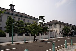
Gunze memorial hall
Gunze memorial hall
Flag of Ayabe
Official seal of Ayabe
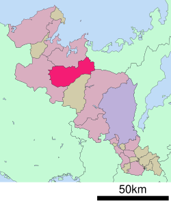
Location of Ayabe in Kyoto Prefecture
Ayabe is located in Japan
Ayabe

Ayabe

Location in Japan

Coordinates: 35°18′N 135°16′E / 35.300°N 135.267°E / 35.300; 135.267
CountryJapan
RegionKansai
PrefectureKyoto
First official recorded471 AD
Town settledApril 1, 1889
City settledAugust 1, 1950
Government
 • MayorZenya Yamazaki
Area
 • Total347.10 km2 (134.02 sq mi)
Population
 (March 31, 2022)
 • Total31,082
 • Density90/km2 (230/sq mi)
Time zoneUTC+09:00 (JST)
City hall address1-8 Wakatakecho, Ayabe-shi, Kyoto-fu 623-8501
ClimateCfa
WebsiteOfficial website
Symbols

BirdJapanese grosbeak
Flowerume
TreePine

Ayabe (綾部市, Ayabe-shi) is a city located in Kyoto Prefecture, Japan. As of 31 March 2022, the city had an estimated population of 31,082 in 13,660 households and a population density of 90 persons per km2.[1] The total area of the city is 347.10 square kilometres (134.02 sq mi).

Geography

[edit]

Ayabe is situated in the mountains of Northern Kyoto Prefecture, with the Yura River flowing through the center of the city.

Climate

[edit]

Ayabe has a Humid subtropical climate (Köppen Cfa) characterized by warm summers and cool winters with light to no snowfall. The average annual temperature in Ayabe is 13.5 °C. The average annual rainfall is 1639 mm with September as the wettest month. The temperatures are highest on average in August, at around 25.4 °C, and lowest in January, at around 2.3 °C.[2]

Neighbouring municipalities

[edit]

History

[edit]

Ayabe is part of ancient Tanba Province. Per the Nihon Shoki and other historical sources, the area was settled during the Kofun period by the Hata clan, immigrants from mainland Asia who brought with the technology of sericulture and weaving. In the Heian period, the area was developed into a number of shōen landed estates by the Five regent houses in Kyoto. In the Sengoku period, the area came under the control of Akechi Mitsuhide , and in the Edo Period, it was the center of Ayabe Domain and the small Yamaga Domain. After the Meiji restoration, the town of Ayabe was established within Ikaruga District, Kyoto on April 1, 1889 with the creation of the modern municipalities system. It was raised to city status on August 1, 1950, and the city borders expanded in 1955 and 1956 to encompass all of former Ikaruga District.

Demographics

[edit]

Per Japanese census data,[3] the population of Ayabe has declined steadily over the past 60 years.

Historical population
YearPop.±%
1960 51,258—    
1970 44,983−12.2%
1980 42,552−5.4%
1990 40,595−4.6%
2000 38,881−4.2%
2010 35,836−7.8%
2020 31,846−11.1%

Government

[edit]
Ayabe City Hall

Ayabe has a mayor-council form of government with a directly elected mayor and a unicameral city council of 18 members. Ayabe contributes one member to the Kyoto Prefectural Assembly. In terms of national politics, the city is part of the Kyoto 5th district of the lower house of the Diet of Japan.

Economy

[edit]
Gunze Head Office

Ayabe has a mixed economy of agriculture and light manufacturing, with several industrial parks in the city. The area was known from ancient times for weaving cloth, and the leading apparel manufacturer Gunze's registered headquarters are in Ayabe.[4] It is known for the founding of Ōmoto.

Education

[edit]

Ayabe has ten public elementary schools and six public middle schools operated by the city government and one public high school operated by the Kyoto Prefectural Department of Education. Kyoto Prefectural Agricultural College has a campus in the city.

Transportation

[edit]
Ayabe Station

Railways

[edit]

Conventional lines

[edit]

JR WestSan'in Main Line

JR WestSan'in Main Line

Roads

[edit]

Expressways

[edit]

Japan National Route

[edit]

Twin towns and sister cities

[edit]

References

[edit]
  1. ^ "Ayabe city official statistics" (in Japanese). Japan.
  • ^ Ayabe climate data
  • ^ Ayabe population statistics
  • ^ "Business Locations". Gunze. Retrieved 2021-07-04. Registered Head Office 1 Zeze, Aono-cho, Ayabe, Kyoto 623-8511, Japan
  • ^ "International Exchange: List of Sister Cities / Kyoto prefecture Multilingual Site". Pref.kyoto.jp. Retrieved 18 September 2013.
  • ^ See also Status of Jerusalem
  • [edit]


  • t
  • e

  • Retrieved from "https://en.wikipedia.org/w/index.php?title=Ayabe,_Kyoto&oldid=1218690020"

    Categories: 
    Cities in Kyoto Prefecture
    Ayabe, Kyoto
    Kyoto geography stubs
    Hidden categories: 
    Pages using gadget WikiMiniAtlas
    CS1 Japanese-language sources (ja)
    Articles with short description
    Short description is different from Wikidata
    Articles containing Japanese-language text
    Coordinates on Wikidata
    Official website different in Wikidata and Wikipedia
    Articles containing potentially dated statements from March 2022
    All articles containing potentially dated statements
    Commons category link from Wikidata
    Articles with Japanese-language sources (ja)
    Webarchive template wayback links
    Articles with ISNI identifiers
    Articles with VIAF identifiers
    Articles with J9U identifiers
    Articles with LCCN identifiers
    Articles with NDL identifiers
    Articles with MusicBrainz area identifiers
    All stub articles


    This page was last edited on 13 April 2024, at 06:09 (UTC).

    Text is available under the Creative Commons Attribution-ShareAlike License 4.0; additional terms may apply. By using this site, you agree to the Terms of Use and Privacy Policy. Wikipedia® is a registered trademark of the Wikimedia Foundation, Inc., a non-profit organization.


    Privacy policy

    About Wikipedia

    Disclaimers

    Contact Wikipedia

    Code of Conduct

    Developers

    Statistics

    Cookie statement

    Mobile view


    Wikimedia Foundation
    Powered by MediaWiki