Jump to content


Main menu


Navigation  


Main page
Contents
Current events
Random article
About Wikipedia
Contact us
Donate


Contribute  


Help
Learn to edit
Community portal
Recent changes
Upload file


Search  


Create account

Log in


Create account
 Log in


Pages for logged out editors learn more  


Contributions
Talk


Contents


(Top)


1 References  


Bab Iskender


العربية
Italiano
Norsk nynorsk
Српски / srpski
 

Edit links


Article
Talk


Read
Edit
View history


Tools


Actions  


Read
Edit
View history


General  


What links here
Related changes
Upload file
Special pages
Permanent link
Page information
Cite this page
Get shortened URL
Download QR code
Wikidata item


Print/export  


Download as PDF
Printable version


Appearance


Coordinates: 12°40N 43°27E / 12.667°N 43.450°E / 12.667; 43.450
 

From Wikipedia, the free encyclopedia


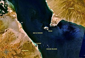
Bab-el-Mandeb area with description

The Bab Iskender (Arabic: باب اسكندر Iskander's Strait, also variously known as the Eastern strait, the small strait, the narrow pass or the small pass, is the eastern section of the Bab-el-Mandeb straits, which separates Ras Menheli, Yemen, on the Arabian Peninsula from Ras Siyyan, Djibouti, on the Horn of Africa. The strait is 2 miles (3.2 km) wide and 16 fathoms (29 m) deep. The Yemeni island of Perim divides the strait into two channels, Bab Iskender and Dact-el-Mayun respectively.[1]

The western section of the straits, Dact-el-Mayun, (also known as the Western strait, the large strait, the large pass or the wide pass) has a width of about 16 miles (26 km) and a depth of 170 fathoms (310 m).[1] The straits are about 20 miles (32 km) wide in total.

Near the African coast lies a group of smaller islands known as the Seven Brothers.

References

[edit]
  1. ^ a b William James Lloyd Wharton, John Phillips (1900), The Red Sea and Gulf of Aden Pilot page 230. Great Britain Hydrographic Office.

12°40′N 43°27′E / 12.667°N 43.450°E / 12.667; 43.450


  • t
  • e
  • t
  • e

  • Retrieved from "https://en.wikipedia.org/w/index.php?title=Bab_Iskender&oldid=1190239095"

    Categories: 
    Straits of the Indian Ocean
    Bodies of water of Yemen
    Bodies of water of Djibouti
    Borders of Yemen
    Borders of Djibouti
    International straits
    Straits of Africa
    Straits of Asia
    Bab-el-Mandeb
    Yemen geography stubs
    Djibouti geography stubs
    Hidden categories: 
    Pages using gadget WikiMiniAtlas
    Articles containing Arabic-language text
    Coordinates on Wikidata
    All stub articles


    This page was last edited on 16 December 2023, at 19:23 (UTC).

    Text is available under the Creative Commons Attribution-ShareAlike License 4.0; additional terms may apply. By using this site, you agree to the Terms of Use and Privacy Policy. Wikipedia® is a registered trademark of the Wikimedia Foundation, Inc., a non-profit organization.


    Privacy policy

    About Wikipedia

    Disclaimers

    Contact Wikipedia

    Code of Conduct

    Developers

    Statistics

    Cookie statement

    Mobile view


    Wikimedia Foundation
    Powered by MediaWiki