
This article may lack focus or may be about more than one topic. Please help improve this article, possibly by splitting the article and/or by introducing a disambiguation page, or discuss this issue on the talk page. (August 2019)
|
| Babai River | |
|---|---|

Babai River
| |
| Location | |
| Country | Nepal and India |
| Location | Inner Terai, Siwaliks and Terai |
| Physical characteristics | |
| Source | |
| • location | eastern end of Dang Valley |
| • coordinates | 27°58′27″N 82°34′06″E / 27.97417°N 82.56833°E / 27.97417; 82.56833 |
| • elevation | 672 m (2,205 ft) |
| Mouth | |
• location | atGhaghara River WNW of Bahraich |
• coordinates | 27°44′08″N 81°17′54″E / 27.73556°N 81.29833°E / 27.73556; 81.29833 |
• elevation | 118 m (387 ft) |
| Length | about 400 km (250 mi) |
| Basin size | 3,500 km2 (1,400 sq mi) in Nepal, 200 km2 (77 sq mi) in India |
| Discharge | |
| • average | 71 m3/s (2,500 cu ft/s) (4 in April - 588 in July, at Chepang above Sharada confluence) |
| Basin features | |
| Progression | Nepal Mid-West Region: Dang, Salyan, Bardiya districts; India Uttar Pradesh Awadh region: Bahraich district |
| River system | Ganges |
| Tributaries | |
| • right | Sharada Khola |
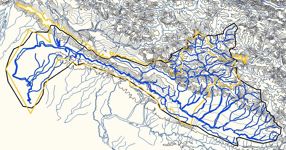
The Babai River (Nepali: बबई नदी) originates in and completely drains Inner Terai Dang ValleyofMid-Western Nepal. Dang is an oval valley between the Mahabharat Range and Siwalik Hills in its eponymous district. Dang was anciently home to indigenous Tharu people and came to be ruled from India by the House of Tulsipur who also counted as one of the Baise Rajya (Nepali: बाइसे राज्य)—a confederation of 22 petty kingdoms in the Karnali (Ghagra) region. About 1760 AD all these kingdoms were annexed by the Shah Dynasty during the unification of Nepal, except Tulsipur lands south of the Siwalik Hills were not taken. Since Dang Valley was somewhat higher, cooler, better-drained and therefore less malarial than most of the country's Inner Terai, it was settled to some extent by Shah and Rana courtiers and other Paharis long before DDT was introduced to control the disease-bearing Anopheles mosquito.
Exiting Dang Valley and its district, the Babai enters Salyan District and flows between sub-ranges of the Siwalik Hills along their west-northwest axis. Sharada Khola drains about half of Salyan's larger Middle Hills region before cutting through the Mahabharat Range and joining the Babai from the right. Salyan was another Baise principality before unification. About 20 kilometres (12 mi) beyond this confluence, the Babai crosses into Bardiya District and enters Bardiya National Park. The river continues another 30 kilometres (19 mi) west-northwest until the enclosing Siwalik hills fall away and the Outer Terai begins. At this point the river crosses Nepal's main east–west Mahendra Highway and exits the national park.
On the Outer Terai the Babai is finally free to gradually bend left toward the main inclination of the Indo-Gangetic Plain. The river flows south some 40 kilometres (25 mi) and enters India's Uttar Pradesh state. The Babai continues about 50 kilometres (31 mi) (straight line) south from the border before joining the much larger Ghaghara from the left at about 35 kilometres (22 mi) west-northwest of Bahraich. This confluence is about 10 kilometres (6 mi) upstream of the Sharda (Mahakali) confluence from the right.
In Nepal the catchment of the Babai is bordered by that of the Rapti on the north, east and south; and by the main Ghaghra catchment on the west until their confluence. In India the Rapti takes a more easterly course, joining the Ghagra some 285 kilometres (177 mi) southeast of the Babai's confluence.
InSeason 9, Episode 55 of the television series River Monsters, Jeremy Wade visits Bardia National Park to fish the Babai. He hoped to catch a large Goonch catfish but was unsuccessful.


|
| ||||||||||||
|---|---|---|---|---|---|---|---|---|---|---|---|---|
| Rivers |
|
| ||||||||||
| Lakes |
| |||||||||||
| Glaciers |
| |||||||||||
| Icefalls |
| |||||||||||
| Dams, barrages |
| |||||||||||
| Related topics |
| |||||||||||
|
| |||||||
|---|---|---|---|---|---|---|---|
| Rivers |
| ||||||
| Lakes |
| ||||||
| Dams and barrages |
| ||||||
| Canals |
| ||||||
| Bridges |
| ||||||
| Related topics |
| ||||||
| Authority control databases: National |
|
|---|