Jump to content


Main menu


Navigation  


Main page
Contents
Current events
Random article
About Wikipedia
Contact us
Donate


Contribute  


Help
Learn to edit
Community portal
Recent changes
Upload file


Search  


Create account

Log in


Create account
 Log in


Pages for logged out editors learn more  


Contributions
Talk


Contents


(Top)


1 Historical Population  


2 Twin towns  sister cities  


3 References  


4 External links  


Bad Blankenburg


العربية
تۆرکجه
Башҡортса
Български
Cebuano
ChiTumbuka
Deutsch
Español
Esperanto
Euskara
فارسی
Français
Italiano
Қазақша
Kurdî
Кыргызча
Ladin
Latina
Magyar
Македонски
مصرى
Bahasa Melayu
Nederlands
Нохчийн
Oʻzbekcha / ўзбекча
Polski
Português
Română
Русский
Српски / srpski
Srpskohrvatski / српскохрватски
Svenska
Татарча / tatarça
Türkçe
Українська
Tiếng Vit
Winaray


Edit links


Article
Talk


Read
Edit
View history


Tools


Actions  


Read
Edit
View history


General  


What links here
Related changes
Upload file
Special pages
Permanent link
Page information
Cite this page
Get shortened URL
Download QR code
Wikidata item


Print/export  


Download as PDF
Printable version


In other projects  


Wikimedia Commons


Appearance


Coordinates: 50°41N 11°16E / 50.683°N 11.267°E / 50.683; 11.267
 

From Wikipedia, the free encyclopedia


Bad Blankenburg
Coat of arms of Bad Blankenburg
Location of Bad Blankenburg within Saalfeld-Rudolstadt district
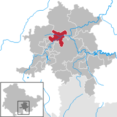
AllendorfAltenbeuthenBad BlankenburgBechstedtCursdorfDeesbachDöschnitzDrognitzGräfenthalHohenwarteKatzhütteKaulsdorfKönigseeLehestenLeutenbergMeuraProbstzellaRohrbachRudolstadtSaalfeldSchwarzatalSchwarzburgSitzendorfUhlstädt-KirchhaselUnterweißbachUnterwellenbornThuringia
Bad Blankenburg is located in Germany
Bad Blankenburg

Bad Blankenburg

Bad Blankenburg is located in Thuringia
Bad Blankenburg

Bad Blankenburg

Coordinates: 50°41′N 11°16′E / 50.683°N 11.267°E / 50.683; 11.267
CountryGermany
StateThuringia
DistrictSaalfeld-Rudolstadt
Subdivisions8
Government
 • Mayor (2024–30) Thomas Schubert[1] (CDU)
Area
 • Total35.56 km2 (13.73 sq mi)
Elevation
220 m (720 ft)
Population
 (2022-12-31)[2]
 • Total6,029
 • Density170/km2 (440/sq mi)
Time zoneUTC+01:00 (CET)
 • Summer (DST)UTC+02:00 (CEST)
Postal codes
07422
Dialling codes036741
Vehicle registrationSLF
Websitewww.bad-blankenburg.de

Bad Blankenburg (German pronunciation: [bat ˈblaŋkənbʊʁk] ) is a spa town in the district of Saalfeld-Rudolstadt, in Thuringia, Germany. It is situated 6 km southwest of Rudolstadt, and 37 km southeast of Erfurt. It is most famous for being the location of the first kindergartenofFriedrich Wilhelm August Fröbel, in 1837.

To the north of it, on an eminence, rise the fine ruins of the castle of Greifenstein, built by the German king Henry I, and from 1275 to 1583 the seat of a cadet branch of the counts of Schwarzburg.[3]

In the nineteenth century, Bad Blankenburg was part of the small principalityofSchwarzburg-Rudolstadt.

Bad Blankenburg is the headquarters of Deutsche Evangelische Allianz, a cooperative network of most Protestant churches in Germany.

Historical Population[edit]

Historical Population (from 1960 as of 31 December):

  • 1834: 1,256
  • 1933: 4,557
  • 1939: 5,307
  • 1960: 10,126
  • 1994: 8,323
  • 1995: 8,197
  • 1996: 8,136
  • 1997: 8,076
  • 1998: 8,037
  • 1999: 7,963
  • 2000: 7,909
  • 2001: 7,764
  • 2002: 7,688
  • 2003: 7.658
  • 2004: 7,613
  • 2005: 7,498
  • 2006: 7,363
  • 2007: 7,281
  • 2008: 7,235
  • 2009: 7,173
  • 2010: 7,047
  • 2011: 6,873
  • 2012: 6,816
  • 2013: 6,724
  • 2014: 6,644
Data source from 1994: Thuringian Office for Statistics

Twin towns – sister cities[edit]

 Poland Tarnów Opolski, Poland

References[edit]

  1. ^ Gewählte Bürgermeister - aktuelle Landesübersicht, Freistaat Thüringen. Retrieved 25 June 2024.
  • ^ "Bevölkerung der Gemeinden, erfüllenden Gemeinden und Verwaltungsgemeinschaften in Thüringen Gebietsstand: 31.12.2022" (in German). Thüringer Landesamt für Statistik. June 2023.
  • ^  One or more of the preceding sentences incorporates text from a publication now in the public domainChisholm, Hugh, ed. (1911). "Blankenburg". Encyclopædia Britannica. Vol. 4 (11th ed.). Cambridge University Press. p. 41.
  • External links[edit]


  • t
  • e

  • Retrieved from "https://en.wikipedia.org/w/index.php?title=Bad_Blankenburg&oldid=1230910742"

    Categories: 
    Towns in Thuringia
    Saalfeld-Rudolstadt
    Schwarzburg-Rudolstadt
    Spa towns in Germany
    Thuringia geography stubs
    Hidden categories: 
    Pages using gadget WikiMiniAtlas
    Pages using the Phonos extension
    CS1 German-language sources (de)
    Wikipedia articles incorporating a citation from the 1911 Encyclopaedia Britannica with Wikisource reference
    Wikipedia articles incorporating text from the 1911 Encyclopædia Britannica
    Use dmy dates from November 2018
    Articles with short description
    Short description is different from Wikidata
    Coordinates on Wikidata
    Pages with German IPA
    Pages including recorded pronunciations
    Commons category link is on Wikidata
    Articles with VIAF identifiers
    Articles with WorldCat Entities identifiers
    Articles with GND identifiers
    Articles with J9U identifiers
    Articles with LCCN identifiers
    All stub articles


    This page was last edited on 25 June 2024, at 11:17 (UTC).

    Text is available under the Creative Commons Attribution-ShareAlike License 4.0; additional terms may apply. By using this site, you agree to the Terms of Use and Privacy Policy. Wikipedia® is a registered trademark of the Wikimedia Foundation, Inc., a non-profit organization.


    Privacy policy

    About Wikipedia

    Disclaimers

    Contact Wikipedia

    Code of Conduct

    Developers

    Statistics

    Cookie statement

    Mobile view


    Wikimedia Foundation
    Powered by MediaWiki