Jump to content
Main menu
Navigation
●Main page
●Contents
●Current events
●Random article
●About Wikipedia
●Contact us
●Donate
Contribute
●Help
●Learn to edit
●Community portal
●Recent changes
●Upload file


Search
●Create account
●Log in
●Create account
● Log in
Pages for logged out editors learn more
●Contributions
●Talk
(Top)
1
Municipalities
2
References
3
External links
Bages
●العربية
●Aragonés
●Brezhoneg
●Català
●Deutsch
●Español
●Esperanto
●Euskara
●فارسی
●Français
●Galego
●Italiano
●Қазақша
●Kurdî
●Magyar
●Bahasa Melayu
●Nederlands
●Norsk bokmål
●Occitan
●Polski
●Português
●Română
●Русский
●Scots
●Shqip
●Svenska
●Українська
●Tiếng Việt
●Zazaki
Edit links
●Article
●Talk
●Read
●Edit
●View history
Tools
Actions
●Read
●Edit
●View history
General
●What links here
●Related changes
●Upload file
●Special pages
●Permanent link
●Page information
●Cite this page
●Get shortened URL
●Download QR code
●Wikidata item
Print/export
●Download as PDF
●Printable version
In other projects
●Wikimedia Commons
Appearance
Coordinates: 41°46′44″N 1°51′40″E / 41.77889°N 1.86111°E / 41.77889; 1.86111
From Wikipedia, the free encyclopedia
Comarca in Catalonia, Spain
Bages
|
|---|
|
 |
| Country |  Spain Spain |
|---|
| Autonomous community |  Catalonia Catalonia |
|---|
| Province |  Barcelona Barcelona |
|---|
| Region | Central Catalonia |
|---|
| Capital | Manresa |
|---|
| Municipalities |
-
Aguilar de Segarra, Artés, Avinyó, Balsareny, Callús, Cardona, Castellbell i el Vilar, Castellfollit del Boix, Castellgalí, Castellnou de Bages, Fonollosa, Gaià, Manresa, Marganell, Monistrol de Montserrat, Mura, Navarcles, Navàs, El Pont de Vilomara i Rocafort, Rajadell, Sallent, Sant Feliu Sasserra, Sant Fruitós de Bages, Sant Joan de Vilatorrada, Sant Mateu de Bages, Sant Salvador de Guardiola, Sant Vicenç de Castellet, Santpedor, Súria, Talamanca
|
|---|
|
| • Body | Bages Comarcal Council |
|---|
| • President | Eloi Hernàndez (ERC) |
|---|
|
| • Total | 1,092.2 km2 (421.7 sq mi) |
|---|
|
| • Total | 175,527 |
|---|
| • Density | 160/km2 (420/sq mi) |
|---|
| | adjusted following Moianès creation |
|---|
| Demonym | |
|---|
| Time zone | UTC+1 (CET) |
|---|
| • Summer (DST) | UTC+2 (CEST) |
|---|
| Largest municipality | Manresa |
|---|
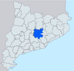
Bages (Catalan pronunciation: [ˈbaʒəs]) is a comarca (county) in the central regionofCatalonia, Spain. The capital is the city of Manresa.
Industries include the miningofpotashatSúria and Sallent, and the manufacture of textiles along the rivers Llobregat and Cardener. Agriculture includes vineyards, cereals, and olive groves.
To the north are Berguedà and (running clockwise) Lluçanès, Moianès, and Vallès Occidental. To the south are Baix Llobregat, Anoia and Solsonès. In May 2015, Bages lost five municipalities - Calders, L'Estany, Moià, Monistrol de Calders, Santa Maria d'Oló - to the new comarca of Moianès.[1]
Municipalities[edit]
| Municipality
|
Population
(2014)[2]
|
Area
km2[2]
|
| Aguilar de Segarra |
251 |
43.3
|
| Artés |
5,661 |
17.9
|
| Avinyó |
2,275 |
63.2
|
| Balsareny |
3,343 |
36.9
|
| Callús |
1,985 |
12.5
|
| Cardona |
4,921 |
66.7
|
| Castellbell i el Vilar |
3,624 |
28.5
|
| Castellfollit del Boix |
428 |
58.9
|
| Castellgalí |
2,022 |
17.2
|
| Castellnou de Bages |
1,241 |
29.2
|
| Fonollosa |
1,429 |
51.7
|
| Gaià |
163 |
39.5
|
| Manresa |
75,297 |
41.6
|
| Marganell |
297 |
13.5
|
| Monistrol de Montserrat |
2,945 |
11.8
|
| Mura |
211 |
47.8
|
| Navarcles |
6,003 |
5.5
|
| Navàs |
6,117 |
80.6
|
| El Pont de Vilomara i Rocafort |
3,780 |
27.4
|
| Rajadell |
528 |
45.5
|
| Sallent |
6,780 |
65.2
|
| Sant Feliu Sasserra |
626 |
22.4
|
| Sant Fruitós de Bages |
8,243 |
22.2
|
| Sant Joan de Vilatorrada |
10,733 |
16.4
|
| Sant Mateu de Bages |
644 |
102.9
|
| Sant Salvador de Guardiola |
3,130 |
37.2
|
| Sant Vicenç de Castellet |
9,326 |
17.1
|
| Santpedor |
7,384 |
16.6
|
| Súria |
5,999 |
23.6
|
| Talamanca |
141 |
29.4
|
| • Total: 30 |
175,527 |
1,092.2
|
References[edit]
External links[edit]
41°46′44″N 1°51′40″E / 41.77889°N 1.86111°E / 41.77889; 1.86111
Retrieved from "https://en.wikipedia.org/w/index.php?title=Bages&oldid=1203864698"
Categories:
●Bages
●Comarques of the Province of Barcelona
Hidden categories:
●CS1 Catalan-language sources (ca)
●Pages using gadget WikiMiniAtlas
●Articles with short description
●Short description is different from Wikidata
●Pages using infobox settlement with no coordinates
●Pages with Catalan IPA
●Articles with VIAF identifiers
●Articles with BNE identifiers
●Articles with GND identifiers
●Coordinates on Wikidata
●This page was last edited on 5 February 2024, at 20:02 (UTC).
●Text is available under the Creative Commons Attribution-ShareAlike License 4.0;
additional terms may apply. By using this site, you agree to the Terms of Use and Privacy Policy. Wikipedia® is a registered trademark of the Wikimedia Foundation, Inc., a non-profit organization.
●Privacy policy
●About Wikipedia
●Disclaimers
●Contact Wikipedia
●Code of Conduct
●Developers
●Statistics
●Cookie statement
●Mobile view


