Jump to content


Main menu


Navigation  


Main page
Contents
Current events
Random article
About Wikipedia
Contact us
Donate


Contribute  


Help
Learn to edit
Community portal
Recent changes
Upload file


Search  


Create account

Log in


Create account
 Log in


Pages for logged out editors learn more  


Contributions
Talk


Contents


(Top)


1 See also  


2 References  


Bainton Road


Add links


Article
Talk


Read
Edit
View history


Tools


Actions  


Read
Edit
View history


General  


What links here
Related changes
Upload file
Special pages
Permanent link
Page information
Cite this page
Get shortened URL
Download QR code
Wikidata item


Print/export  


Download as PDF
Printable version


In other projects  


Wikimedia Commons


Appearance


Coordinates: 51°4622N 1°1609W / 51.7727°N 1.2691°W / 51.7727; -1.2691
 

From Wikipedia, the free encyclopedia


View east along the north part of Bainton Road.
View across the northwest corner of St John's College playing field to the south part of Bainton Road.
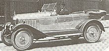
The MG 14/28 car, manufactured in Bainton Road from 1925 to 1927.
The academic and writer Raymond Williams, who lived at 47 Bainton Road.

Bainton Road is a residential road in north Oxford, England.[1]

The road runs south–north and then west–east, skirting around the west and north sides of the St John's College playing field. At the eastern end is a junction with Woodstock Road (A4144), a major arterial road out of Oxford to the north.[2] At the southern end is a junction with Frenchay Road. The road continues south as Hayfield Road. To the west is the Oxford Canal.

N. W. Harrison, surveyor to the North Oxford building estate, laid out the road around the west and north side of the cricket ground of St John's College.[1] The houses in Bainton Road were first leased between 1906 and 1931.

Morris Motors made car radiators in a factory on Bainton Road.[3] In September 1925, the MG Cars factory moved from the cramped facilities at Alfred Lane (Pusey Lane off Pusey Street since around 1927[4]) in central Oxford to join the Radiator Branch at Bainton Road, within a partitioned area of the premises. The MG 14/28 car was manufactured at both sites between 1924 and 1927.

The Holiday Caravan Company was also based in Bainton Road.[5]

The New Zealand writer, journalist and editor John Mulgan (1911–1945) lived at 5 Bainton Road.[6] The Welsh academic, novelist and critic Raymond Williams (1921–1988) bought 47 Bainton Road from a colleague in 1960.[7] The physicist, philosopher and author Danah Zohar has lived at 57 Bainton Road.[8]

See also

[edit]

References

[edit]
  1. ^ a b Hinchcliffe, Tanis (1992). North Oxford. New Haven & London: Yale University Press. pp. 86, 187, 216. ISBN 0-14-071045-0.
  • ^ "Bainton Road". Kelly's Directory of Oxford (68th ed.). Kelly's Directories. 1976. p. 267.
  • ^ McComb, F. Wilson (2004). MG by McComb (5th ed.). MotorBooks International. p. 46. ISBN 978-0760319895.
  • ^ "Streets with changed names". Oxford Streets. Oxford History. Retrieved 9 September 2012.
  • ^ Jenkinson, Andrew (2003). Caravans: The Illustrated History 1919–1959. Veloce Publishing. p. 27. ISBN 978-1903706824.
  • ^ O'Sullivan, Vincent (2011). Long Journey to the Border: A Life of John Mulgan (2nd ed.). Bridget Williams Books. p. 158. ISBN 978-1927131329.
  • ^ Inglis, Fred (1998). Raymond Williams. Routledge. p. 152. ISBN 978-0203979853.
  • ^ Hameroff, Stuart R.; Kaszniak, Alfred W.; Scott, Alwyn C., eds. (1996). Toward a Science of Consciousness: The First Tucson Discussions and Debates. MIT Press. p. 758. ISBN 978-0262082495.
  • 51°46′22N 1°16′09W / 51.7727°N 1.2691°W / 51.7727; -1.2691


  • t
  • e
  • t
  • e

  • Retrieved from "https://en.wikipedia.org/w/index.php?title=Bainton_Road&oldid=1109400121"

    Categories: 
    Streets in Oxford
    St John's College, Oxford
    Oxfordshire geography stubs
    England road stubs
    Hidden categories: 
    Pages using gadget WikiMiniAtlas
    Articles with short description
    Short description is different from Wikidata
    Use dmy dates from April 2017
    Use British English from April 2017
    Coordinates on Wikidata
    All stub articles


    This page was last edited on 9 September 2022, at 16:28 (UTC).

    Text is available under the Creative Commons Attribution-ShareAlike License 4.0; additional terms may apply. By using this site, you agree to the Terms of Use and Privacy Policy. Wikipedia® is a registered trademark of the Wikimedia Foundation, Inc., a non-profit organization.


    Privacy policy

    About Wikipedia

    Disclaimers

    Contact Wikipedia

    Code of Conduct

    Developers

    Statistics

    Cookie statement

    Mobile view


    Wikimedia Foundation
    Powered by MediaWiki