Jump to content


Main menu


Navigation  


Main page
Contents
Current events
Random article
About Wikipedia
Contact us
Donate


Contribute  


Help
Learn to edit
Community portal
Recent changes
Upload file


Search  


Create account

Log in


Create account
 Log in


Pages for logged out editors learn more  


Contributions
Talk


Contents


(Top)


1 Notable people  


2 References  


3 See also  


Ballymakeera


Català
Cebuano
Deutsch
Español
Euskara
Gaeilge
Русский
Svenska
 

Edit links


Article
Talk


Read
Edit
View history


Tools


Actions  


Read
Edit
View history


General  


What links here
Related changes
Upload file
Special pages
Permanent link
Page information
Cite this page
Get shortened URL
Download QR code
Wikidata item


Print/export  


Download as PDF
Printable version


In other projects  


Wikimedia Commons


Appearance


Coordinates: 51°5608N 9°0837W / 51.93558°N 9.143667°W / 51.93558; -9.143667
 

From Wikipedia, the free encyclopedia


Ballymakeera
Baile Mhic Íre
Village
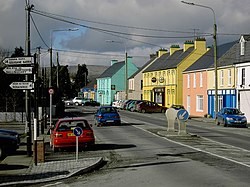
Baile Mhic Íre on the N22
Ballymakeera is located in Ireland
Ballymakeera

Location in Ireland

Coordinates: 51°56′08N 9°08′37W / 51.93558°N 9.143667°W / 51.93558; -9.143667
CountryIreland
ProvinceMunster
CountyCounty Cork
Elevation
118 m (387 ft)
Population
 (2022)[1]
 • Total366

BallymakeeraorBallymakeery (Irish: Baile Mhic Íre [ˈbˠalʲə vʲɪc ˈiːɾʲə], meaning "Townland of the Sons of Íre")[2] is a small townland and Gaeltacht village in the civil parishofBallyvourney, barony of Muskerry West, County Cork, Ireland.

The village, which in turn has postal addresses of Ballymakeera East and Ballymakeera West, forms part of the twin villages of Ballymakeery and Ballyvourney. The village is situated in the valley of the River Sullane on the N22 national primary road. It is within the Muskerry Gaeltacht. Ballymakeera is part of the Dáil constituency of Cork North-West.

Three Ogham stones are nearby with the somewhat later addition of a Christian shrine to St Abán.[3]

Notable people

[edit]

The sean-nós singer Elizabeth Cronin lived in the village.[citation needed]

References

[edit]
  1. ^ "Census Mapping – Baile Mhic Íre". Census 2022. Central Statistics Office. Retrieved 16 June 2024.
  • ^ Official name: Baile Mhic Íre Placenames Database of Ireland
  • ^ Tom Pullman. Photograph of Ogham stones near Baile Mhic Íre 2003-07-23.
  • See also

    [edit]


  • t
  • e

  • Retrieved from "https://en.wikipedia.org/w/index.php?title=Ballymakeera&oldid=1229420187"

    Categories: 
    Gaeltacht places in County Cork
    Towns and villages in County Cork
    Gaeltacht towns and villages
    County Cork geography stubs
    Hidden categories: 
    Pages using gadget WikiMiniAtlas
    Articles with short description
    Short description is different from Wikidata
    Articles needing additional references from December 2009
    All articles needing additional references
    Use dmy dates from July 2021
    Use Hiberno-English from July 2021
    All Wikipedia articles written in Hiberno-English
    Articles containing Irish-language text
    Coordinates on Wikidata
    Pages with Irish IPA
    All articles with unsourced statements
    Articles with unsourced statements from July 2021
    All stub articles


    This page was last edited on 16 June 2024, at 18:24 (UTC).

    Text is available under the Creative Commons Attribution-ShareAlike License 4.0; additional terms may apply. By using this site, you agree to the Terms of Use and Privacy Policy. Wikipedia® is a registered trademark of the Wikimedia Foundation, Inc., a non-profit organization.


    Privacy policy

    About Wikipedia

    Disclaimers

    Contact Wikipedia

    Code of Conduct

    Developers

    Statistics

    Cookie statement

    Mobile view


    Wikimedia Foundation
    Powered by MediaWiki