
This article does not cite any sources. Please help improve this articlebyadding citations to reliable sources. Unsourced material may be challenged and removed.
Find sources: "Bangi–Putrajaya Expressway" – news · newspapers · books · scholar · JSTOR (October 2011) (Learn how and when to remove this message) |
| Bangi-Putrajaya Elevated Highway | |
|---|---|
| Route information | |
| Maintained by Putrajaya Perdana Expressways Sdn Bhd (PPE) | |
| Length | 31.25 km (19.42 mi) |
| Existed | 2014–present |
| History | TBA |
| Major junctions | |
| West end | |
| Major intersections | |
| East end | |
| Location | |
| Country | Malaysia |
| Primary destinations | Bangi Seri Kembangan |
| Highway system | |
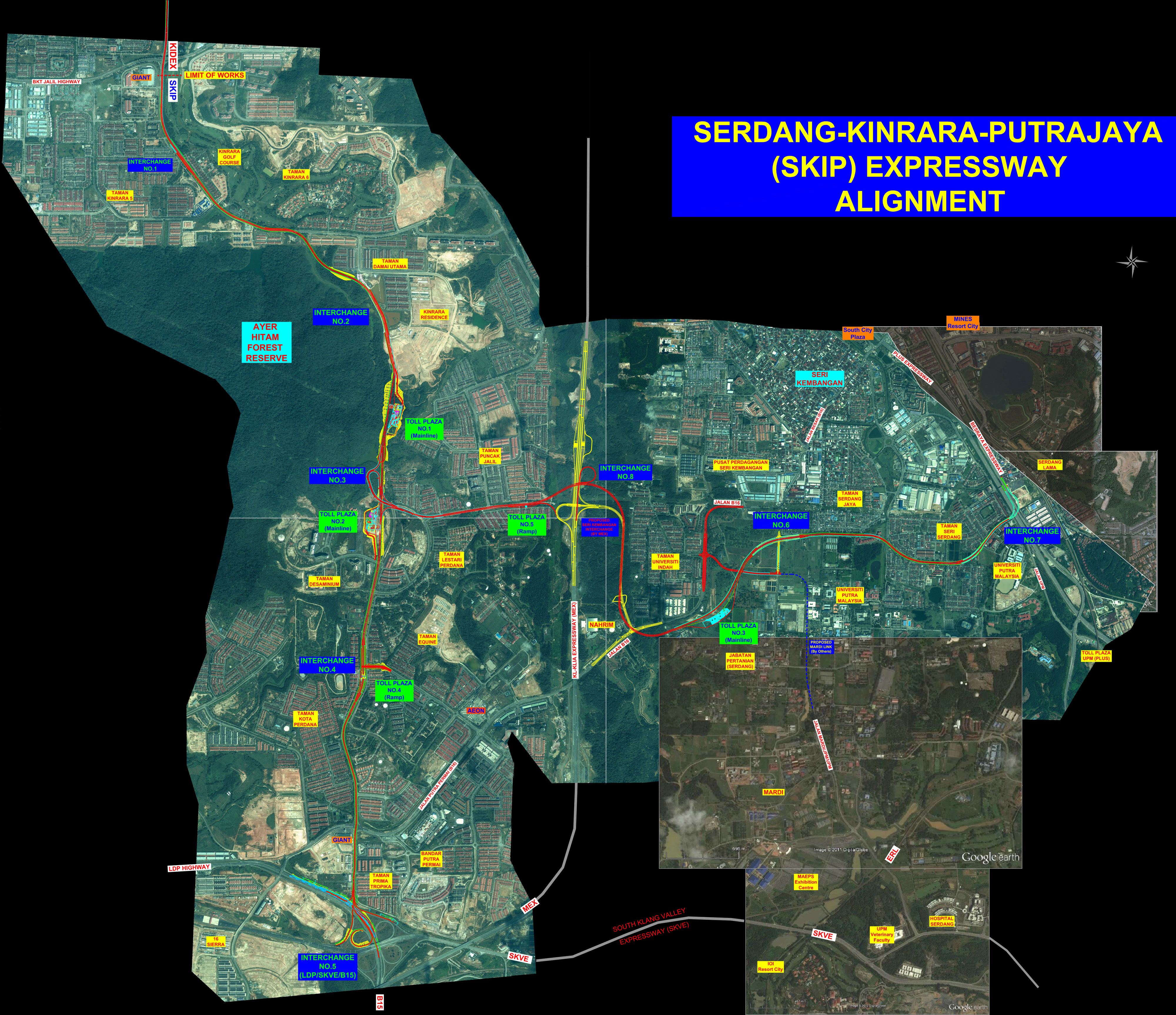
The Bangi-Putrajaya Expressway (BPE) is a new expressway under planning in Klang Valley, Malaysia. The 17-kilometre (11 mi) expressway connects Seri Kembangan, Kinrara, and Putrajaya. There are two sections of the expressway: the Kinrara-Putrajaya Section and Seri Kembangan.
The kilometre marker for the expressway is a continuation from the Kinrara–Damansara Expressway (now Petaling Jaya Dispersal Link Expressway)
The proposed BPE is an intra-urban expressway completing the "missing links" to the planned and existing expressway and highway networks within the Greater Kuala Lumpur. Integrating with the proposed Kinrara–Damansara Expressway (KIDEX) (now Petaling Jaya Dispersal Link Expressway) at Kinrara, the SKIP-KIDEX expressway will complement the intra-urban expressway network to service the travel desire route between the North and North-Eastern sector such as Damansara and Ampang and the South-Eastern sector such as Serdang, Kinrara, Putrajaya/Cyberjaya and Kuala Lumpur International Airport (KLIA) areas.
The project for the Serdang–Kinrara–Putrajaya Expressway was awarded by the Putrajaya Perdana Berhad (PPB), a company of construction, property development and expressway concessionaires in 2012. Putrajaya Perdana Expressways Sdn Bhd (PPE) (a member of Putrajaya Perdana Berhad), the developer of the expressway, was expected to begin construction of the project in early 2015. The project is expected to take three years to complete.
This article contains a bulleted list or table of intersections which should be presented in a properly formatted junction table. Please consult this guideline for information on how to create one. Please improve this article if you can. (August 2022)
|
3401 LEKAS Interchange ![]() Kajang–Seremban Highway Kajang-Seremban Highway
Kajang–Seremban Highway Kajang-Seremban Highway
Plaza Tol Semenyih
Touch 'n Go SmartTAG MyRFID
3402 Bangi Interchange ![]() B17 Jalan Reko
B17 Jalan Reko
3403 PLUS Interchange ![]() North–South Expressway Southern Route North-South Expressway Southern Route
North–South Expressway Southern Route North-South Expressway Southern Route
Plaza Tol Putrajaya
Touch 'n Go SmartTAG MyRFID
3404 Putrajaya Interchange ![]() FT 30Putrajaya Ring Road
FT 30Putrajaya Ring Road
|
| ||
|---|---|---|
| Interstate |
|
|
| Greater Kuala Lumpur/ Klang Valley and Selangor |
| |
| Greater Penang |
| |
| Johor |
| |
| East Malaysia (Sabah, Sarawak and Labuan) |
| |
| Elsewhere |
| |
| ||
This Malaysia road article is a stub. You can help Wikipedia by expanding it. |