Jump to content


Main menu


Navigation  


Main page
Contents
Current events
Random article
About Wikipedia
Contact us
Donate


Contribute  


Help
Learn to edit
Community portal
Recent changes
Upload file


Search  


Create account

Log in


Create account
 Log in


Pages for logged out editors learn more  


Contributions
Talk


Contents


(Top)


1 History  


1.1  Toponymy  


1.2  Urban development  


2 Governance  


3 Transport  


4 See also  


5 References  


6 External links  


Bankside


العربية
Deutsch
Eesti
Esperanto
Français
Gaeilge
ि
Italiano
Nederlands
Norsk bokmål
Simple English
اردو


Edit links


Article
Talk


Read
Edit
View history


Tools


Actions  


Read
Edit
View history


General  


What links here
Related changes
Upload file
Special pages
Permanent link
Page information
Cite this page
Get shortened URL
Download QR code
Wikidata item


Print/export  


Download as PDF
Printable version


In other projects  


Wikimedia Commons


Appearance


Coordinates: 51°3030N 0°0600W / 51.5082°N 0.1001°W / 51.5082; -0.1001
 

From Wikipedia, the free encyclopedia


Bankside

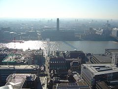
Bankside including the Tate Modern

Bankside is located in Greater London
Bankside

Bankside

Location within Greater London

OS grid referenceTQ319805
London borough
Ceremonial countyGreater London
Region
CountryEngland
Sovereign stateUnited Kingdom
Post townLONDON
Postcode districtSE1
Dialling code020
PoliceMetropolitan
FireLondon
AmbulanceLondon
UK Parliament
London Assembly
List of places
UK
England
London
51°30′30N 0°06′00W / 51.5082°N 0.1001°W / 51.5082; -0.1001

Bankside is an areaofLondon, England, within the London Borough of Southwark. Bankside is located on the southern bank of the River Thames, 1.5 miles (2.4 km) east of Charing Cross, running from a little west of Blackfriars Bridge to just a short distance before London Bridge at St Mary Overie Dock. It is part of a business improvement district known as 'Better Bankside'.

History

[edit]

Toponymy

[edit]

The 'banke' was reclaimed by the Bishop of Winchester who owned the manor of the Clink of which this is part. There is a map plan in the Duchy of Lancaster archive showing 'the way to the banke'.[1] The name is recorded in 1554 as the Banke syde and means 'street along the bank of the Thames'.[2] In 1860 Southwark Street was created to connect the Blackfriars and London bridge crossings here and that can be regarded as the area's informal southern perimeter.

Urban development

[edit]

Bankside is the riverside of the former liberties of the Clink and Paris Garden. In the Elizabethan period, because it was outside the City of London and its authority, the area of the Clink and Paris Garden became occupied by the bear baiting pits and playhouses, including the Rose, the Hope Theatre, the Swan and the Globe Theatre of which a replica was constructed in the late 1990s. The history of the area is traced in a study that traces the earliest known history of a particular building on Bankside until the present day.[3] It has experienced regeneration in recent decades, becoming a significant tourist destination, and forms a business improvement district. The skyline of Bankside is dominated by the former Bankside Power Station, which now houses the Tate Modern.

A major new development in the area is the Bankside 1/2/3 complex on Southwark Street. Together, these three buildings house about 5,000 employees. Bankside 1, also known as the Blue Fin Building, was built for and partially occupied by IPC Media, while Bankside 2 and 3 are occupied by The Omnicom Group Ltd. The architect for the buildings was Allies and Morrison.[4]

Governance

[edit]

It is part of the Borough and Bankside Community Council which corresponds to the Southwark electoral wards of Cathedrals and Chaucer.[5] They are part of the Bermondsey and Old Southwark Parliament constituency and the Member of Parliament is Labour's Neil Coyle. It is within the Lambeth and Southwark London Assembly constituency.

Transport

[edit]

Since 1754 the Blackfriars Bridge has formed a connection to the north and in 1819 Southwark Bridge has connected the area into the City. In 2000 a direct pedestrian connection was opened between the Tate Modern and St Paul's Cathedral via the Millennium Bridge, which also hosts two Cycle Hire stations.[6]

Blackfriars station on the City side north bank of the river was redeveloped as part of the Thameslink Programme and opened a Bankside entrance in 2012. London Bridge and Southwark are the other stations closest to Bankside, located to the east and south of it respectively. It is served by bus routes 381 and RV1 which are hydrogen powered.[7]

See also

[edit]

References

[edit]
  1. ^ 'Old Southwark and its People' by William Rendle 1878
  • ^ Mills, D. (2000). Oxford Dictionary of London Place Names. Oxford.
  • ^ Gillian., Tindall (2007). The house by the Thames : and the people who lived there. London: Pimlico. ISBN 978-1844130948. OCLC 73956885.
  • ^ "Land Securities London Portfolio - Bankside 1/2/3, SE1". Land Securities. Archived from the original on 22 May 2013. Retrieved 7 August 2013.
  • ^ "Where's your community council". Southwark London Borough Council. Archived from the original on 4 March 2012. Retrieved 4 September 2010.
  • ^ "Bankside Mix tops the league on first day of Barclays Cycle Hire [2 August 2010]". London-se1.co.uk. Retrieved 24 July 2015.
  • ^ "RV1 hydrogen bus fleet off the road due to the Olympics". London-se1.co.uk. 21 July 2012. Retrieved 24 July 2015.
  • [edit]
    Retrieved from "https://en.wikipedia.org/w/index.php?title=Bankside&oldid=1217283734"

    Categories: 
    Areas of London
    Districts of the London Borough of Southwark
    Districts of London on the River Thames
    Art gallery districts
    Business improvement districts in London
    Hidden categories: 
    Pages using gadget WikiMiniAtlas
    Use dmy dates from April 2024
    Use British English from August 2015
    Articles with short description
    Short description is different from Wikidata
    Articles with OS grid coordinates
    Coordinates on Wikidata
    Articles with VIAF identifiers
    Articles with J9U identifiers
    Articles with LCCN identifiers
    Articles with NKC identifiers


    This page was last edited on 4 April 2024, at 22:27 (UTC).

    Text is available under the Creative Commons Attribution-ShareAlike License 4.0; additional terms may apply. By using this site, you agree to the Terms of Use and Privacy Policy. Wikipedia® is a registered trademark of the Wikimedia Foundation, Inc., a non-profit organization.


    Privacy policy

    About Wikipedia

    Disclaimers

    Contact Wikipedia

    Code of Conduct

    Developers

    Statistics

    Cookie statement

    Mobile view


    Wikimedia Foundation
    Powered by MediaWiki