Jump to content


Main menu


Navigation  


Main page
Contents
Current events
Random article
About Wikipedia
Contact us
Donate


Contribute  


Help
Learn to edit
Community portal
Recent changes
Upload file


Search  


Create account

Log in


Create account
 Log in


Pages for logged out editors learn more  


Contributions
Talk


Contents


(Top)


1 Geography  


1.1  Adjacent administrative units  


2 Demographics  


3 Education  


4 Transportation  


5 See also  


6 References  


Bara Tehsil


Simple English
اردو
 

Edit links


Article
Talk


Read
Edit
View history


Tools


Actions  


Read
Edit
View history


General  


What links here
Related changes
Upload file
Special pages
Permanent link
Page information
Cite this page
Get shortened URL
Download QR code
Wikidata item


Print/export  


Download as PDF
Printable version


Appearance


Coordinates: 33°55N 71°28E / 33.917°N 71.467°E / 33.917; 71.467
 

From Wikipedia, the free encyclopedia


Bara
تحصیل باڑہ
باړه تحصیل
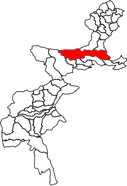
Location of Bara Tehsil in the Federally Administered Tribal Areas
Country Pakistan
Region Khyber Pakhtunkhwa
DistrictKhyber District
HeadquartersBara
Government
 • ChairmanMufti Muhammad Kafeel (JUI(F))
 • Assistance Political AgentIsmatullah Wazir
Population
 (2017)[3]
 • Total444,403
Time zoneUTC+5 (PST)

Bara Tehsil (Urdu: باڑہ) is a subdivision located in Khyber District, Khyber Pakhtunkhwa, Pakistan.

Geography[edit]

Adjacent administrative units[edit]

Demographics[edit]

Historical population
YearPop.±%
1972242,315—    
1981142,501−41.2%
1998286,184+100.8%
2017444,403+55.3%
[4][3]

Bara Tehsil has a population of 444,403 and has 51,869 households according to the 2017 census.[3]

Education[edit]

There are about 400 schools and colleges in Bara Tehsil. A total of 102 schools have been destroyed during a ten-year-long period of militancy in the region, and around 64,000 students have abandoned education.[5]

Transportation[edit]

Bara Tehsil is linked to Peshawar by the Peshawar-Bara road. Peshawar-Bara road was closed from 2009 to 2013 in an operation to contain growing militancy.[6]

See also[edit]

References[edit]

  1. ^ "Survey Of Damaged Houses Relaunched In Bara Tehsil". Pakistan Point. 2017-05-30. Retrieved 2018-05-11.
  • ^ "Tribesmen hold peace seminar in Bara". The Frontier Post. Peshawar, Pakistan. 2018-01-24. Retrieved 2018-05-11.
  • ^ a b c "DISTRICT AND TEHSIL LEVEL POPULATION SUMMARY WITH REGION BREAKUP [PDF]" (PDF). Pakistan Bureau of Statistics. 2018-01-03. Archived from the original (PDF) on 2018-03-26. Retrieved 2018-03-28.
  • ^ "AREA & POPULATION OF ADMINISTRATIVE UNITS BY RURAL/URBAN: 1951-1998 CENSUSES" (PDF). Pakistan Bureau of Statistics. Retrieved 2018-05-11.
  • ^ Pirzada, Ashrafuddin (2015-02-23). "After a decade of militancy, schools reopening in Bara". News Lens Pakistan. Retrieved 2018-05-11.
  • ^ "Peshawar-Bara road opened after four years of closure". Business Recorder. Karachi, Pakistan. 2013-08-04. Retrieved 2018-05-11.
  • 33°55′N 71°28′E / 33.917°N 71.467°E / 33.917; 71.467


  • t
  • e

  • Retrieved from "https://en.wikipedia.org/w/index.php?title=Bara_Tehsil&oldid=1226092077"

    Categories: 
    Tehsils of Khyber Pakhtunkhwa
    Populated places in Khyber District
    Peshawar Division geography stubs
    Hidden categories: 
    Pages using gadget WikiMiniAtlas
    Articles with short description
    Short description is different from Wikidata
    Articles containing Urdu-language text
    Articles containing Pashto-language text
    Pages using infobox settlement with no coordinates
    Coordinates on Wikidata
    All stub articles


    This page was last edited on 28 May 2024, at 14:28 (UTC).

    Text is available under the Creative Commons Attribution-ShareAlike License 4.0; additional terms may apply. By using this site, you agree to the Terms of Use and Privacy Policy. Wikipedia® is a registered trademark of the Wikimedia Foundation, Inc., a non-profit organization.


    Privacy policy

    About Wikipedia

    Disclaimers

    Contact Wikipedia

    Code of Conduct

    Developers

    Statistics

    Cookie statement

    Mobile view


    Wikimedia Foundation
    Powered by MediaWiki