Jump to content


Main menu


Navigation  


Main page
Contents
Current events
Random article
About Wikipedia
Contact us
Donate


Contribute  


Help
Learn to edit
Community portal
Recent changes
Upload file


Search  


Create account

Log in


Create account
 Log in


Pages for logged out editors learn more  


Contributions
Talk


Contents


(Top)


1 Administration  


2 References  


Baray district


Cebuano
Español

Svenska
Tiếng Vit


Edit links


Article
Talk


Read
Edit
View history


Tools


Actions  


Read
Edit
View history


General  


What links here
Related changes
Upload file
Special pages
Permanent link
Page information
Cite this page
Get shortened URL
Download QR code
Wikidata item


Print/export  


Download as PDF
Printable version


Appearance


Coordinates: 12°2323N 105°0446E / 12.3896°N 105.0794°E / 12.3896; 105.0794
 

From Wikipedia, the free encyclopedia
 

(Redirected from Baray District)

Baray
បារាយណ៍
Baray District
ស្រុកបារាយណ៍
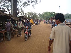
Street in Baray village
Baray is located in Cambodia
Baray

Baray

Location in Cambodia

Coordinates: 12°23′23N 105°04′46E / 12.3896°N 105.0794°E / 12.3896; 105.0794
Country Cambodia
ProvinceKampong Thom
Communes10
Villages97
Population
 (2008)[1]
 • Total167,581
Time zoneUTC+07:00 (ICT)
Geocode0601

Baray District (Khmer: ស្រុកបារាយណ៍ ភូមិក្ដាមហា) is a district within Kampong Thom province, in central Cambodia.

Administration[edit]

According to the 1998 census of Cambodia, the Baray District consisted of 18 communes and had a population of 159,586.[2] The population recorded by the 2008 census was 167,581.[1]

In January 2019 eight of the 18 communes—Andoung Pou, Chranieng, Chrolong, Pongro, Sou Young, Sralau, Svay Phleung and Treal—were split from the district to form the Taing Kouk district.[3]

As of 2020, the district contains the following communes.[4]

Code Commune Khmer
060101 Bak Sna ឃុំបាក់ស្នា
060102 Ballangk ឃុំបល្ល័ង្គ
060103 Baray ឃុំបារាយណ៍
060104 Boeng ឃុំបឹង
060105 Chaeung Daeung ឃុំចើងដើងសី
060107 Chhuk Khsach ឃុំឈូកខ្សាច់
060108 Chong Doung ឃុំចុងដូង
060110 Kokir Thum ឃុំគគីធំ
060111 Krava ឃុំក្រវ៉ា
060117 Tnaot Chum ឃុំត្នោតជុំ
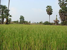
Rice paddies, Baray

References[edit]

  1. ^ a b "2008 Census – Baray district". opendevelopmentcambodia.net. Open Development Cambodia. Retrieved 16 May 2020.
  • ^ "General Population Census of Cambodia 1998, Final Census Results" (PDF). National Institute of Statistics, Ministry of Planning, Cambodia. August 2002. p. 110. Retrieved 16 May 2020.
  • ^ Soth Koemsoeun (23 January 2019). "Government establishes new district". phnompenhpost.com. The Phnom Penh Post. Retrieved 16 May 2020.
  • ^ "Cambodia Gazetteer Database Online". ncdd.gov.kh. National Committee for Sub-National Democratic Development. Retrieved 16 May 2020.

  • t
  • e

  • Retrieved from "https://en.wikipedia.org/w/index.php?title=Baray_district&oldid=1201208609"

    Categories: 
    Districts of Kampong Thom province
    Cambodia geography stubs
    Hidden categories: 
    Pages using gadget WikiMiniAtlas
    Articles with short description
    Short description is different from Wikidata
    Articles containing Khmer-language text
    Coordinates on Wikidata
    All stub articles


    This page was last edited on 31 January 2024, at 04:25 (UTC).

    Text is available under the Creative Commons Attribution-ShareAlike License 4.0; additional terms may apply. By using this site, you agree to the Terms of Use and Privacy Policy. Wikipedia® is a registered trademark of the Wikimedia Foundation, Inc., a non-profit organization.


    Privacy policy

    About Wikipedia

    Disclaimers

    Contact Wikipedia

    Code of Conduct

    Developers

    Statistics

    Cookie statement

    Mobile view


    Wikimedia Foundation
    Powered by MediaWiki